Ice Age Model

freethisone

Re: Ice Age Model
« Reply #350, on January 3rd, 2015, 02:15 AM »Last edited on January 3rd, 2015, 02:27 AM
follow this link to see what i had to say about star trek.http://open-source-energy.org/?topic=58.75

so some of these ideas seem far fetched, but we know now this has a high probability of accuracy. Known information hidden from the people, and its true culture. Ice age model was based on Precession, and axil shift. therefore in concluding we must now now by the preponderance of the evidence . this  also has a high probability of accuracy. due to data log and effort..Much more can be learned.


Matt Watts

Re: Ice Age Model
« Reply #351, on January 3rd, 2015, 02:29 AM »
So I'm confused Free, were these events calculated, predicted as in time travel, or were they planned far in advance?  I can't think of any other way to get accurate data.

freethisone

Re: Ice Age Model
« Reply #352, on January 3rd, 2015, 04:43 AM »
this is ice age model. therefore is was known way in advance. That is because Books, and information like to disappear in our reality.Are these people human?

only religion has keep this account of the passing of these particular objects. true uncovered, then shared by men of statures.
an original idea was not the case.

If i was traveling through time i would like a platform that is moving very fast. for a launch that would bring higher velocity.  So i don't know what time travel has to do with ice age model,

now im really confused.

  .

freethisone

Re: Ice Age Model
« Reply #353, on January 3rd, 2015, 04:15 PM »
[


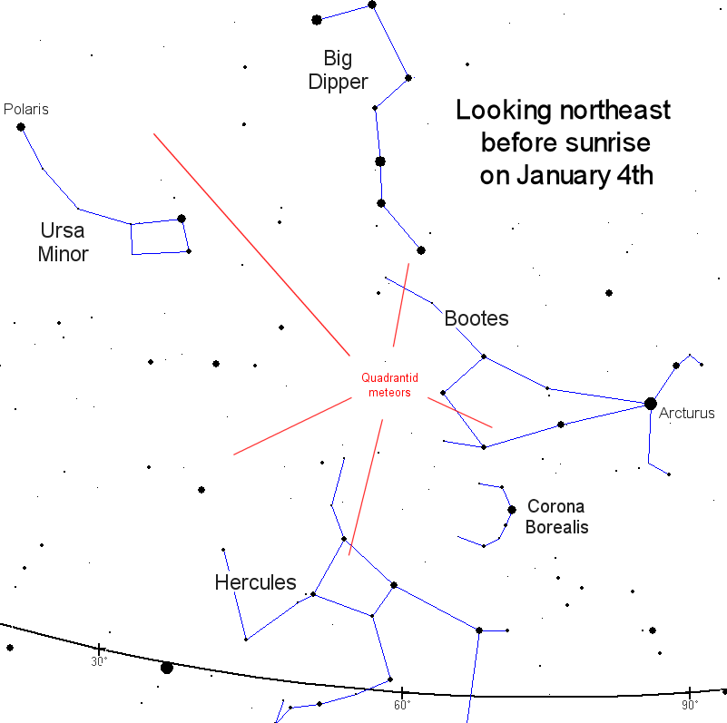
From the information provided corral Castle compare Spika star showcased, and re occurring fiery object. east follow the handle of the big dipper.
now look at the meteor shower vector, then locate these stars surrounding, and Spika star. 


how do we learn about the symbolic nature of this study? by looking at it from a scientific point of view.

ice age model now predicts eruptions, and M X class solar flares coming weeks. objects of high potential orbital period. temple one comet.


taken what was learned in 2010 and 2011 of objects of high brightness.  the position of this increasing potential shows us it is this object in question.

remember corral castle  Spika star. .observations are in order with vector potential, in this direction. coming right out of the black board. therefore it is true we also have debris associated with it.  Could it be that Spika is this star? kepler 186?  :huh:


 Meteors from a Shattered Comet:
the Quadrantids
Spaceweather.com
   
Global Notes: This is a northern hemisphere shower.


The Quadrantid meteor shower is one of the year's best, often producing more than 100 meteors per hour from a radiant near the North Star. In 2012 forecasters expect the shower to peak around 07:20 UT (02:20 am EST) on Wednesday, January 4. The peak is brief, typically lasting no more than an hour or so, and it does not always occur at the forecasted time, so observers are encouraged to be alert for meteors throughout the early hours of January 4th.

Although the Quadrantids are a major shower, they are seldom observed. One reason is weather. The shower peaks in early January when northern winter is in full swing. Storms and cold tend to keep observers inside.

Above: In 2008, NASA-supported scientists flew an airplane above the clouds and over the Arctic Circle to gain a good view of the shower. Jeremie Vaubaillon of Caltech recorded these Quadrantids streaking through the aurora borealis outside the window of the plane.


Another reason is brevity. The shower doesn't last long, a few hours at most. Even dedicated meteor watchers are likely to miss such a sharp peak. In his classic book Meteor Astronomy, Prof. A.C.B. Lovell lamented that "useful counts of the Quadrantid rate were made in [only] 24 Januaries out of a possible 68 between 1860 and 1927. ... The maximum rate appears to have occurred in 1932 (80 per hour) although the results are influenced by unfavorable weather."

The source of the Quadrantid meteor shower was unknown until Dec. 2003 when Peter Jenniskens of the NASA Ames Research Center found evidence that Quadrantid meteoroids come from 2003 EH1, an "asteroid" that is probably a piece of a comet that broke apart some 500 years ago. Earth intersects the orbit of 2003 EH1 at a perpendicular angle, which means we quickly move through any debris. That's why the shower is so brief.

Quadrantid meteors take their name from an obsolete constellation, Quadrans Muralis, found in early 19th-century star atlases between Draco, Hercules, and Bootes. It was removed, along with a few other constellations, from crowded sky maps in 1922 when the International Astronomical Union adopted the modern list of 88 officially-recognized constellations. The Quadrantids, which were "re-zoned" to Bootes after Quadrans Muralis disappeared, kept their name--possibly because another January shower was already widely-known to meteor watchers as the "Bootids."

Got clouds? No problem. You can stay inside and listen to the Quadrantids. Tune into SpaceWeather Radio for a live audio stream from the Air Force Space Surveillance Radar. When a Quadrantid passes over the facility, you will hear a "ping" caused by the radar's powerful transmitter echoing from the meteor's ion trail. During the shower's peak, the soundtrack is guaranteed to entertain.


 Spica is a bright binary star, the 16th brightest in Earth's night sky, visible in the northern constellation Virgo. It is visible not only because of its size, but also because of its relatively close distance: it is about 260 light-years away from Earth.

While the star appears as a single point of light to the naked eye, Spica is a binary system. One star, however, is much brighter than the other one.

The star system is also a massive source of X-rays, which opened a new understanding of Spica when X-ray astronomy became prominent in the 1960s.

freethisone

Re: Ice Age Model
« Reply #354, on January 9th, 2015, 12:32 PM »Last edited on January 9th, 2015, 12:40 PM
Quote from freethisone on December 24th, 2014, 02:43 AM
Fogo volcano (Cape Verde): continuing lava flows

Mon, 22 Dec 17:40

The eruption continues its destructive work: the lava effusion from the vents remains at moderate intensity and feeds various active flows that spread in the Cha Caldera.
While the foremost front that had destroyed Portela and Bangaeira two weeks ago is no longer active, several lateral breakouts continue to spread in the caldera.
Whatever has so far been spared or only partially covered of buildings from the two villages, is being gradually covered by the flows. [less]
[read all]
Fogo volcano (Cape Verde): Lava destruction & photographic documentation by Martin Rietze

Fri, 19 Dec 23:48


Lava cascade during the Fogo eruption (Dec 2014) (copyright: Martin Rietze)
It seems that after a short period of quietening down (9-14 December) the Fogo eruption has regained its strength. This confirms our earlier report of increased emission of sulphur dioxide thought to indicate the rise of a new magma batch.
After nearly 20 years of inactivity, the Pico de Fogo awakened with a violent flank eruption on the 23rd of November 2014. In less than 4 weeks , this eruption has devastated local communities and caused a humanitarian crisis as it forced 1500 local people to flee and it is likely that another 2000 will have to move to temporary shelters. Media coverage of this natural disaster has so far been remarkably small despite the fact that it is Fogo’s largest volcanic eruption in decades, causing more damage to nearby settlements, and in a shorter time, than the 1995 eruption. [less]


this is a pre cursor what is to follow. the next explosives eruptions are expected from various volcanoes of the world.

surely ice age model has proven this is the case, x and m class flairs intensifies over the next 20 days. 7.0 or higher earthquakes are presumed during the same time frame..
a couple more powerful eruption should be excepted.40 day out  look.
ok here is a summery of ice age model. i had assumed explosive eruption. so let the data show.. we had this powerful eruption 18 days out.

what will follow some very powerful earthquakes, and storms. another 20 day out look will be reflected.

.. 7.2 or better. we may say 6.3 or better as a norm. as a result of torque times :heart: delta t.


Volcanoes Today, 7 Jan 2015: Shiveluch volcano, Kilauea, Hunga Tonga-Hunga Ha'apai, Fogo

Wednesday Jan 07, 2015 14:00 PM |

Eruption column from Shiveluch this morning

Map showing the location of the lava flow near Pahoa as of 6 Jan 2015 (HVO/USGS)
Fogo (Cape Verde): Activity continues, but overall the eruption has been decreasing and seems slowly to be coming to an end.
Still, short bursts of explosive and effusive activity occur from the vents occasionally, producing ash plumes and short-lived lava flows. Yesterday, such an increase resulted in an ash plume reaching 1.5 km and a new 50 m long lava flow near the vents. Minor ash fall occurred on the city of Sao Felipe.
The recently active western lava flow has apparently stopped by now, but during the past days managed to destroy the last remaining buildings in Ilhéu Losna.

Shiveluch (Kamchatka): A very large vulcanian explosion occurred this morning at the volcano (at 00:41 UTC, 7:41 am local time). The explosion produced a 1.5 km wide ash column rising to approx. 27,000 ft (9 km) altitude and several pyroclastic flows from partial column collapse that traveled to the south.

now look at the next 20 days of scrutiny.  earth quake info for the last 20 days will be reflected, O:-)

freethisone

Re: Ice Age Model
« Reply #355, on January 9th, 2015, 08:52 PM »


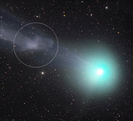
they claim a magnetic storm is on this comet ?

what we have here is coronal discharge of  objects of small radius that reflect the total energy that surrounds these charges,objects of high radius of high potential, and surface area. the electric field.


freethisone

Re: Ice Age Model
« Reply #356, on January 11th, 2015, 12:08 AM »
Volcanic activity worldwide 6 Jan 2015: Soputan volcano

Tuesday Jan 06, 2015 21:00 PM |


The eruption of the volcano Soputan observed from the volcano observatory post (images: PVMBG / twitter)
Soputan (North Sulawesi, Indonesia): The volcano erupted this morning at 02:45 local time with a strong explosion from the summit lava dome. It sent an 6 km tall ash column to approx. 26,000 ft (8,5 km) altitude.
The eruption followed an increase in seismic activity in December, when so-called "drumbeat" earthquakes appeared - a type of volcanic tremor typically associated with movements of viscous magma at shallow depths,- in this case new lava rising beneath the existing lava dome (in place since 1991). As a consequence, the alert status of the volcano had been raised to the second highest level "Siaga" (3 on a scale of 1-4, alert).
 ... [show less]
 Today's explosion caused parts of the summit dome that occupies the crater, open to the western flank, to collapse and produce a glowing avalanche that traveled approx. 2000 m, remaining within the volcano's caldera. It seems that no pyroclastic flow (which could sweep over the caldera walls and into inhabited areas below) occurred.


freethisone

Re: Ice Age Model
« Reply #358, on January 17th, 2015, 12:48 PM »Last edited on January 17th, 2015, 12:54 PM
Volcanoes Today, 16 Jan 2015: Etna volcano

Fri, 16 Jan 22:00


Etna volcano update: Sporadic ash emissions from North East crater

Fri, 16 Jan 21:57


Dilute ash emissions from Etna's NE crater on 15 Jan 2015 (Etnatrekking webcam Linguaglossa)
Unrest continues at the summit craters. After strombolian activity from the Central Crater (Voragine) had ceased around 13 Jan, weak ash emissions occurred from the North-East crater yesterday.  ...more

 More about Etna volcano

Volcanic activity worldwide 16 Jan 2015: Hunga Tonga-Hunga Ha'apai volcano

Fri, 16 Jan 21:00


Eruption between Hunga Tonga and Hunga Ha’apai island on 15 Jan (New Zealand High Commission)
Hunga Tonga-Hunga Ha'apai (Tonga, Tonga Islands): A new island is now growing at the eruption site between Hunga Ha’apai and Hunga Tonga Islands. As of yesterday, it had an east-west elongated 1.5-2 km long and approx. 1 km wide shape with a half-open cone around the crater reaching almost 100 m in height already.  ...more


 [read all]
Hunga Tonga-Hunga Ha'apai volcano (Tonga Islands) eruption: new island grows rapidly

Fri, 16 Jan 18:52


Eruption between Hunga Tonga and Hunga Ha’apai island on 15 Jan (New Zealand High Commission)
A new island is now growing at the eruption site between Hunga Ha’apai and Hunga Tonga Islands. As of yesterday, it had an east-west elongated 1.5-2 km long and approx. 1 km wide shape with a half-open cone around the crater reaching almost 100 m in height already.  ...more


 [read all] More about Hunga Tonga-Hunga Ha'apai volcano


to top


Volcanic activity worldwide 15 Jan 2015: Pacaya volcano

Thu, 15 Jan 21:00


Weak incandescent spot, but no degassing from Mackenney crater on 8 Jan 2015 (Landsat 8 image / processed by Rudiger Escobar Wolf @rudigerescobar / twitter)
Pacaya (Guatemala): The volcano is becoming active again. In a special bulletin yesterday, INSIVUMEH reported that ash emissions occurred from the volcano.  ...more


 [read all]
Pacaya volcano (Guatemala): new activity

Thu, 15 Jan 12:03


Weak incandescent spot, but no degassing from Mackenney crater on 8 Jan 2015 (Landsat 8 image / processed by Rudiger Escobar Wolf @rudigerescobar / twitter)
The volcano is becoming active again. In a special bulletin yesterday, INSIVUMEH reported that ash emissions occurred from the volcano.  ...more


 [read all] More about Pacaya volcano

Volcanic activity worldwide 14 Jan 2015: Dukono volcano

Wed, 14 Jan 21:00

Dukono (Halmahera): Ash emissions continue. A stronger phase of activity last night produced a plume at estimated 7,000 ft (2.1 km) extending 25 km to the southeast. (Darwin VAAC)  ...more

Dukono volcano (Halmahera, Indonesia) activity update

Wed, 14 Jan 17:45

Ash emissions continue. A stronger phase of activity last night produced a plume at estimated 7,000 ft (2.1 km) extending 25 km to the southeast. (Darwin VAAC)
More about Dukono volcano


freethisone

Re: Ice Age Model
« Reply #359, on January 22nd, 2015, 04:21 PM »Last edited on January 22nd, 2015, 04:23 PM
Quote from freethisone on January 9th, 2015, 12:32 PM
a couple more powerful eruption should be excepted.40 day out  look.
ok here is a summery of ice age model. i had assumed explosive eruption. so let the data show.. we had this powerful eruption 18 days out.

what will follow some very powerful earthquakes, and storms. another 20 day out look will be reflected.

.. 7.2 or better. we may say 6.3 or better as a norm. as a result of torque times :heart: delta t.


Volcanoes Today, 7 Jan 2015: Shiveluch volcano, Kilauea, Hunga Tonga-Hunga Ha'apai, Fogo

Wednesday Jan 07, 2015 14:00 PM |

Eruption column from Shiveluch this morning

Map showing the location of the lava flow near Pahoa as of 6 Jan 2015 (HVO/USGS)
Fogo (Cape Verde): Activity continues, but overall the eruption has been decreasing and seems slowly to be coming to an end.
Still, short bursts of explosive and effusive activity occur from the vents occasionally, producing ash plumes and short-lived lava flows. Yesterday, such an increase resulted in an ash plume reaching 1.5 km and a new 50 m long lava flow near the vents. Minor ash fall occurred on the city of Sao Felipe.
The recently active western lava flow has apparently stopped by now, but during the past days managed to destroy the last remaining buildings in Ilhéu Losna.

Shiveluch (Kamchatka): A very large vulcanian explosion occurred this morning at the volcano (at 00:41 UTC, 7:41 am local time). The explosion produced a 1.5 km wide ash column rising to approx. 27,000 ft (9 km) altitude and several pyroclastic flows from partial column collapse that traveled to the south.

now look at the next 20 days of scrutiny.  earth quake info for the last 20 days will be reflected, O:-)
Volcanic activity worldwide 21 Jan 2015: Karymsky volcano, Colima, Soputan, Dukono, Bagana, Suwanose...

Wednesday Jan 21, 2015 21:00 PM |


Modis / Aqua satellite view over Kamchatka this morning

Soputan's activity yesterday (?) (Photo: Ist / Manado Express)

Initial stage of the eruption at Colima this morning (photo: Sunao (Tom) Tobaru ‏@coloneltobaru / twitter)
Karymsky (Kamchatka): More explosions have occurred at the volcano. Tokyo VAAC reported ash plumes to 7-12,000 ft (2.1-3.6 km) elevation drifting SE.

Zhupanovsky (Kamchatka, Russia): Mild ash emissions are visible on latest satellite images.
Today's clear weather over Kamchatka allowed MODIS satellites to take a shot with all 4 currently active volcanoes: Zhupanovsky, Karymsky (ash emissions from explosions), Klyuchevskoy (lava flow and ash plumes), and Shiveluch north of the latter, also with ash emissions.

Suwanose-jima (Ryukyu Islands): Intermittent, probably strombolian activity persists at the On-take crater. JMA reported a small explosion from the volcano yesterday, but bad weather conditions don't allow clear webcam images.

Bagana (Bougainville Island, Papua New Guinea): A volcanic ash plume to estimated 12,000 ft extending 20 nautical miles to the NE was detected by Darwin VAAC this morning.

Soputan (North Sulawesi, Indonesia): The eruption of the volcano continues. The new lava flow seems to have descended almost to the base of the summit cone, accompanied by abundant glowing rockfalls. Intermittent explosions, although decreasing in intensity during the past 2 days, still produce ash emissions that reach 3-4 km altitude.
The volcano remains at level 3 (out of 4, "Siaga") and the Aviation Color Code at Red.
So far, the impact of the eruption has been limited to light ash fall in some nearby villages, mainly Silian and Lobu. No evacuations have been ordered.

Dukono (Halmahera): Abundant ash emissions occur from the volcano. A plume stretching 50 km to the SW was seen on MTSAT imagery by Darwin VAAC this morning.

Colima (Western Mexico): A strong vulcanian-type explosion occurred this morning at 09:15 from the volcano's summit. An ash column rose more than 4 km above the summit, reaching eventually estimated approx. 29,000 ft (9 km) altitude and drifting NE.
A small pyroclastic flow that descended the steep slope of the volcano was generated during the explosion.
Ash fall occurred in Tuxpan, Zapotiltic and Ciudad Guzmán in the Jalisco district.


a list of many ongoing with many to follow.


Currently erupting:
Ambrym (Vanuatu): active lava lakes in several craters (updated 14 Aug 2013)
Aso (Kyushu): intense strombolian activity from main vent in Nakadake crater (updated 20 Jan 2015)
Bardarbunga (Central Iceland): lava lake, sporadic fountains, lava flow (updated 18 Sep 2014)
Barren Island (Indian Ocean): intermittent activity, likely strombolian-type and/or lava flows (updated 4 Feb 2014)
Batu Tara (Sunda Islands, Indonesia): strombolian explosions, ash plumes up to 500 m, extrusion of a small lava dome with rockfalls (updated 4 Nov 2014)
Colima (Western Mexico): slowly growing lava dome, occasional explosions (updated 21 Jan 2015)
Copahue (Chile/Argentina): ash venting (updated 4 Dec 2014)
Daikoku (Volcano Islands): underwater eruption discovered on 14 Dec 2014 (updated 22 Dec 2014)
Dukono (Halmahera): thermal anomaly, probably small explosive activity in summit crater (updated 21 Jan 2015)
Erebus (Antarctica): active lava lake in summit crater (updated 8 Dec 2014)
Erta Ale (Ethiopia): active lava lake in northern pit crater, active hornito with intermittend flow in southern crater (updated 11 Jan 2013)
Fuego (Guatemala): strombolian explosions from summit crater, intermittent lava flows (updated 19 Jan 2015)
Gamalama (Halmahera): new eruption on 18 Dec 2014 (updated 22 Dec 2014)
Hunga Tonga-Hunga Ha'apai (Tonga, Tonga Islands): surtseyan activity, growing new island (updated 16 Jan 2015)
Ibu (Halmahera, Indonesia): stromolian and phreatomagmatic explosions (updated 14 Nov 2014)
Karymsky (Kamchatka): occasional small explosions, thermal anomaly (updated 21 Jan 2015)
Kilauea (Hawai'i): new lava flow from vents on NE flank of Pu'u 'O'o (updated 13 Aug 2013)
Kliuchevskoi (Kamchatka): strombolian activity at summit crater, possible short lava flow (updated 20 Jan 2015)
Manam (Papua New Guinea): degassing, occasional ash venting (updated 28 Aug 2013)
Marapi (Western Sumatra, Indonesia): sporadic explosions (updated 27 Mar 2014)
Nasu (Honshu)
Nishino-shima (Volcano Islands, Japan): growing island (updated 19 Jan 2015)
Nyamuragira (DRCongo): active lava lake (updated 29 Nov 2014)
Nyiragongo (DRCongo): active lava lake in summit crater (updated 26 Feb 2014)
Ol Doinyo Lengai (Tanzania): effusion of natrocarbonatite lava inside the crater (updated 8 Jul 2013)
Poas (Costa Rica): phreatic explosions (updated 14 Oct 2014)
Popocatépetl (Central Mexico): degassing, sporadic explosions, slowly growing lava dome (updated 3 Jan 2015)
Rabaul (Tavurvur) (New Britain, Papua New Guinea): lava fountains, ash emissions from Tavurvur cone (updated 12 Sep 2014)
Raung (East Java): mild strombolian activity in summit crater (updated 2 Dec 2014)
Reventador (Ecuador): lava flow on southwestern flank, intermittent explosions (updated 7 Dec 2014)
Sakurajima (Kyushu, Japan): ash venting, intermittent explosions (updated 20 Jan 2015)
Sangeang Api (Indonesia): growing lava dome & lava flow (updated 7 Jul 2014)
Santiaguito (Guatemala): small explosions from the Caliente dome and active lava flow (updated 19 Jan 2015)
Semeru (East Java, Indonesia): growing lava dome, lava flow, strombolian activity (updated 26 Nov 2014)
Shiveluch (Kamchatka): growing lava dome, incandescent avalanches, occasional explosions (updated 18 Jan 2015)
Sinabung (Sumatra, Indonesia): continuing pyroclastic flows (updated 19 Jan 2015)
Soputan (North Sulawesi, Indonesia): active viscous lava flow, explosions, rockfalls, pyroclastic flows (updated 21 Jan 2015)
Tungurahua (Ecuador): moderate to strong strombolian explosions from central crater (updated 25 Sep 2014)
Ubinas (Peru): degassing, sporadic small explosions and ash venting (updated 11 Sep 2014)
Yasur (Tanna Island, Vanuatu): ash emissions, weak strombolian explosions (updated 14 Aug 2013)
Zhupanovsky (Kamchatka, Russia): intermittent ash emissions (updated 21 Jan 2015)

freethisone

Re: Ice Age Model
« Reply #360, on January 23rd, 2015, 08:40 AM »Last edited on January 23rd, 2015, 08:50 AM
14 day later  we have this. 6 more days to complete this 20 day evaluation. The next 40 to 80 days will be looked at with a microscope,. and look grim.temple one is closing in, feb 14 to 16th out look,   i will tell you now it will not be difficult to make the correct assumption.  explosive eruption, major flooding and axial shift. m and x class flair will cross the spark gap. 6 days outlook will give me time to put it in the proper prespective, many are learning ice age model is a accurate model of ongoing plate shift, and external  torque. temple one heartly 2. and we have kepler 186 186f , love joy or ison, your choice. :heart:


M6.8 - 84km NNE of Port-Vila, Vanuatu


Data Source US3

Map showing extent (w,s,e,n) = (163.5314, -22.0004, 173.5314, -12.000399999999999)
17.000°S 168.531°E depth=218.5 km
View interactive map


Event Time
2015-01-23 03:47:27 (UTC)
2015-01-22 22:47:27 (UTC-05:00) in your timezone
Times in other timezones


M6.9 earthquake strikes off Vanuatu
By Web Staff Published: January 22, 2015, 6:18 pm Updated: January 22, 2015, 6:26 pm


PTWC PTWC

TSUNAMI INFORMATION STATEMENT NUMBER 1
NWS PACIFIC TSUNAMI WARNING CENTER EWA BEACH HI
551 PM HST THU JAN 22 2015

TO – EMERGENCY MANAGEMENT IN THE STATE OF HAWAII


    ORIGIN TIME – 0548 PM HST 22 JAN 2015
    COORDINATES – 17.3 SOUTH 168.6 EAST
    LOCATION – VANUATU
    MAGNITUDE – 6.9 MOMENT

EVALUATION

BASED ON ALL AVAILABLE DATA A DESTRUCTIVE PACIFIC-WIDE TSUNAMI IS NOT EXPECTED AND THERE IS NO TSUNAMI THREAT TO HAWAII. REPEAT. A DESTRUCTIVE PACIFIC-WIDE TSUNAMI IS NOT EXPECTED AND THERE IS NO TSUNAMI THREAT TO HAWAII.

THIS WILL BE THE ONLY STATEMENT ISSUED FOR THIS EVENT UNLESS ADDITIONAL DATA ARE RECEIVED.

6,9 PLUS PLUS

its my estimate :@ that this quake was much stronger then reported.

freethisone

Re: Ice Age Model
« Reply #361, on January 26th, 2015, 10:03 PM »
Quote from freethisone on January 17th, 2015, 12:48 PM
Volcanoes Today, 16 Jan 2015: Etna volcano

Fri, 16 Jan 22:00


Etna volcano update: Sporadic ash emissions from North East crater

Fri, 16 Jan 21:57


Dilute ash emissions from Etna's NE crater on 15 Jan 2015 (Etnatrekking webcam Linguaglossa)
Unrest continues at the summit craters. After strombolian activity from the Central Crater (Voragine) had ceased around 13 Jan, weak ash emissions occurred from the North-East crater yesterday.  ...more

 More about Etna volcano

Volcanic activity worldwide 16 Jan 2015: Hunga Tonga-Hunga Ha'apai volcano

Fri, 16 Jan 21:00


Eruption between Hunga Tonga and Hunga Ha’apai island on 15 Jan (New Zealand High Commission)
Hunga Tonga-Hunga Ha'apai (Tonga, Tonga Islands): A new island is now growing at the eruption site between Hunga Ha’apai and Hunga Tonga Islands. As of yesterday, it had an east-west elongated 1.5-2 km long and approx. 1 km wide shape with a half-open cone around the crater reaching almost 100 m in height already.  ...more


 [read all]
Hunga Tonga-Hunga Ha'apai volcano (Tonga Islands) eruption: new island grows rapidly

Fri, 16 Jan 18:52


Eruption between Hunga Tonga and Hunga Ha’apai island on 15 Jan (New Zealand High Commission)
A new island is now growing at the eruption site between Hunga Ha’apai and Hunga Tonga Islands. As of yesterday, it had an east-west elongated 1.5-2 km long and approx. 1 km wide shape with a half-open cone around the crater reaching almost 100 m in height already.  ...more


 [read all] More about Hunga Tonga-Hunga Ha'apai volcano


to top


Volcanic activity worldwide 15 Jan 2015: Pacaya volcano

Thu, 15 Jan 21:00


Weak incandescent spot, but no degassing from Mackenney crater on 8 Jan 2015 (Landsat 8 image / processed by Rudiger Escobar Wolf @rudigerescobar / twitter)
Pacaya (Guatemala): The volcano is becoming active again. In a special bulletin yesterday, INSIVUMEH reported that ash emissions occurred from the volcano.  ...more


 [read all]
Pacaya volcano (Guatemala): new activity

Thu, 15 Jan 12:03


Weak incandescent spot, but no degassing from Mackenney crater on 8 Jan 2015 (Landsat 8 image / processed by Rudiger Escobar Wolf @rudigerescobar / twitter)
The volcano is becoming active again. In a special bulletin yesterday, INSIVUMEH reported that ash emissions occurred from the volcano.  ...more


 [read all] More about Pacaya volcano

Volcanic activity worldwide 14 Jan 2015: Dukono volcano

Wed, 14 Jan 21:00

Dukono (Halmahera): Ash emissions continue. A stronger phase of activity last night produced a plume at estimated 7,000 ft (2.1 km) extending 25 km to the southeast. (Darwin VAAC)  ...more

Dukono volcano (Halmahera, Indonesia) activity update

Wed, 14 Jan 17:45

Ash emissions continue. A stronger phase of activity last night produced a plume at estimated 7,000 ft (2.1 km) extending 25 km to the southeast. (Darwin VAAC)
More about Dukono volcano

Worldwide Volcano News and Updates:

 
latest (Jan 2015) | Dec 2014 | Nov 2014 | archive

Volcanic activity worldwide 26 Jan 2015: Kliuchevskoi volcano, Shiveluch, Dukono, Suwanose-jima, Zhupanovsky

Mon, 26 Jan 21:00


Incandescence from strombolian activity at Klyuchevskoy volcano this morning
Kliuchevskoi (Kamchatka): The eruptive activity has weakened a bit, but remains near-continuous. Small ash emissions from strombolian activity occurred yesterday and bright glow from this activity illuminates the volcano's summit at night.  ...more


 [read all]
Volcanoes Today, 26 Jan 2015: Kliuchevskoi volcano, Shiveluch, Dukono, Suwanose-jima, Zhupanovsky

Mon, 26 Jan 11:00


Suwanose-jima volcano (Ryukyu Islands, Japan) activity update

Mon, 26 Jan 10:11

Occasional strombolian eruptions occur from time to time. An explosion was reported yesterday (Tokyo VAAC).
More about Suwanose-jima volcano

Kliuchevskoi volcano (Kamchatka) activity update

Mon, 26 Jan 09:20


Incandescence from strombolian activity at Klyuchevskoy volcano this morning
The eruptive activity has weakened a bit, but remains near-continuous. Small ash emissions from strombolian activity occurred yesterday and bright glow from this activity illuminates the volcano's summit at night.  ...more


 More about Kliuchevskoi volcano


to top


Dukono volcano (Halmahera, Indonesia) activity update

Mon, 26 Jan 09:17

Significant ash emissions were observed again this morning. Tokyo VAAC reported a plume extending 20 nautical miles to the SW, at estimated 10,000 ft (3 km) altitude.
More about Dukono volcano

Zhupanovsky volcano (Kamchatka, Russia) activity update

Mon, 26 Jan 09:00

Intermittent ash emissions continue. A plume at 10,000 ft (3 km) altitude was detected extending SSE on satellite imagery this morning (Tokyo VAAC).
More about Zhupanovsky volcano

Shiveluch volcano (Kamchatka, Russia): explosive eruption this morning

Mon, 26 Jan 08:58


Explosion at Shiveluch this morning. Note the incandescent deposits of glowing bombs on the flanks and inside (along with lightning?) the eruption column.
A strong vulcanian-type explosion occurred this morning. An ash plume rose to approx. 25,000 ft (7.5 km) altitude and a pyroclastic flow seems to have descended to the SE.
 
Rising ash plume of the eruption
More about Shiveluch volcano

Volcanic activity worldwide 24 Jan 2015: Kliuchevskoi volcano, Colima, Sakurajima

Sat, 24 Jan 21:00


Ash plume and incandescence from strombolian activity at Klyuchevskoy volcano yesterday
Kliuchevskoi (Kamchatka): Moderate to strong strombolian activity continues at the summit crater, producing a sustained plume that rises approx. 1500 m above the summit and drifts eastwards.  ...more


 [read all]

to top


Sakurajima volcano (Japan): explosion with ash plume to 5 km reported

Sat, 24 Jan 11:17


Mild explosive activity from Sakurajima today
An unusually strong explosion occurred yesterday at 20:36 local time. VAAC Tokyo reported an ash plume to 16,000 ft (5 km) altitude. Today, the volcano has been much calmer with only a few smaller eruptions and phases of ash emissions. More about Sakurajima volcano

Klyuchevskoy volcano (Kamchatka): strong strombolian activity

Sat, 24 Jan 10:43


Ash plume and incandescence from strombolian activity at Klyuchevskoy volcano yesterday
Moderate to strong strombolian activity continues at the summit crater, producing a sustained plume that rises approx. 1500 m above the summit and drifts eastwards.  ...more


 [read all] More about Kliuchevskoi volcano

freethisone

Re: Ice Age Model
« Reply #362, on January 28th, 2015, 04:16 PM »
Quote from freethisone on January 9th, 2015, 12:32 PM
a couple more powerful eruption should be excepted.40 day out  look.
ok here is a summery of ice age model. i had assumed explosive eruption. so let the data show.. we had this powerful eruption 18 days out.

what will follow some very powerful earthquakes, and storms. another 20 day out look will be reflected.

.. 7.2 or better. we may say 6.3 or better as a norm. as a result of torque times :heart: delta t.


Volcanoes Today, 7 Jan 2015: Shiveluch volcano, Kilauea, Hunga Tonga-Hunga Ha'apai, Fogo

Wednesday Jan 07, 2015 14:00 PM |

Eruption column from Shiveluch this morning

Map showing the location of the lava flow near Pahoa as of 6 Jan 2015 (HVO/USGS)
Fogo (Cape Verde): Activity continues, but overall the eruption has been decreasing and seems slowly to be coming to an end.
Still, short bursts of explosive and effusive activity occur from the vents occasionally, producing ash plumes and short-lived lava flows. Yesterday, such an increase resulted in an ash plume reaching 1.5 km and a new 50 m long lava flow near the vents. Minor ash fall occurred on the city of Sao Felipe.
The recently active western lava flow has apparently stopped by now, but during the past days managed to destroy the last remaining buildings in Ilhéu Losna.

Shiveluch (Kamchatka): A very large vulcanian explosion occurred this morning at the volcano (at 00:41 UTC, 7:41 am local time). The explosion produced a 1.5 km wide ash column rising to approx. 27,000 ft (9 km) altitude and several pyroclastic flows from partial column collapse that traveled to the south.

now look at the next 20 days of scrutiny.  earth quake info for the last 20 days will be reflected, O:-)
this quake right here was at least 6.3 or better.


News
5.7 Magnitude Earthquake Shakes Northern California
Published Jan 28 2015 05:11 PM EST
weather.com

A map from the USGS shows the location of Wednesday's earthquake.  (USGS)

An earthquake with several aftershocks in Northern California startled people across the region during an otherwise quiet Wednesday afternoon.

The 5.7-magnitude tremor hit at 1:08 p.m. PT and was centered in the water outside of Ferndale, California, which is about 260 miles north of San Francisco.

The USGS originally said the quake was a magnitude 5.1, but quickly upgraded it to magnitude 5.7.

The Humboldt County Sheriff’s Office said no damage was reported, but people from Eureka east into Chico felt weak to moderate shaking, according to the USGS.

Several aftershocks were reported in the immediate minutes following the original quake.


freethisone

Re: Ice Age Model
« Reply #364, on January 30th, 2015, 05:56 PM »Last edited on January 30th, 2015, 06:13 PM
’1000 mile swath of the U.S. may be destroyed within 2 weeks from an extinction level event’, says park geologist
  January 30, 2015 6:44 pm EST 3 Comments
FacebookTwitterGoogleSubscribe
Yellowstone supervolcano on verge of eruption; USGS suppressing information

By Shepard Ambellas

WYOMING (INTELLIHUB) — As of January 29, 2015, Hank Hessler, a park geologist stationed at Yellowstone National Park since 2002, publicly announced and put only a 2 week time-frame for the supervolcano located under the park to erupt.

Although no one knows for sure if Hessler’s prediction will come true, it does set an eerie overtone for people located within a 1000 mile swath of the park.

Interestingly enough this information dovetails with information previously reported by Intellihub, making Hessler’s claims all that much more real. Not to mention the fact that there was more than 1,900 documented earthquakes throughout the park in 2014 alone as swarm activity continues to increase.

On March 4, 2014, Intellihub came across information, by an unnamed source, who reported that the White House had ordered the United States Geological Survey (USGS) to suppress earthquake swarm data within the region to hide what may be coming from the general public. And this is where it gets scary as Yellowstone and a 1000 mile swath surrounding the park’s supervolcano may be on the brink of an extinction level event (ELE).
eruption

Yellowstone National Park (Jeff Gunn/Flickr)

In fact reports suggest that ancient Helium4 gas has breached the surface layers of Yellowstone’s crust and is now escaping into the earth’s atmosphere. Coupled with the recent and abrupt ground level rise in the park we may be looking at a recipe for disaster.

After all, Michio Kaku, a famous theoretical physicist, pointed out in a January 2011 newscast which aired on CNN, “When it blows [Yellowstone] it could destroy the United States as we know it. [...] That’s what is making us nervous”

Shockingly, later in the newscast, Kaku went on to explain how a 1000-mile ring of the U.S. would likely be destroyed if the supervolcano actually went. And to make matters worse, geologists all conclude that the park is long overdue for an eruption.

In fact, the last Yellowstone eruption was thought to have happened around 630,000 years ago, meaning we are about 30,000 years overdue, literally putting us in the hot seat, front row.

Kaku also pointed out that, “Every single burp, murmur, of this gigantic supervolcano, including the rise above sea level, has to be watched very carefully”.

So basically if you do the math for the disaster zone radius, the first 100-miles emanating out from ground zero would be completely wiped out. After that, ninety percent devastation would span out another 500 plus miles from ground zero, making a 1000-mile diameter ring that will essentially be fully decimated from the blast.

Additionally this would essentially put what’s left of the United States into a State of Emergency and full-on martial law would be declared under National Security Presidential Directive (NSPD) 51.

And it gets even worse. Although there is no way I can vouch for the information, I simply can’t. But according to a random individual who posted a video on YouTube, the USGS has likely been ordered by Washington to suppress information regarding recent seismic activity and gaseous releases in and around the Yellowstone region as a possible ELE in on the way.
steam

Yellowstone National Park (Jeff Gunn/Flickr)

This information came directly from a connected individual, according to the video, which also points out that they are “expecting the big one”. However the man’s source has not yet been revealed. And once again, I myself cannot vouch for this personally. I just want to make that clear.

But more importantly all of this matches up with actual data I was able to reference showing a rise of ground level in the park of more than 10 inches in the last week of February 2014 alone. So naturally this has me troubled as Michio Kaku himself stated, “As the ground starts to rise, more and more earthquakes take place,that’s about all the warning we get”, answering a question regarding a forewarning.

Kaku finished with, “It will happen and [when it does] it will destroy North America as we know it”.

During the last eruption, 640,000 years ago, vast amounts of North America were covered in at least 12 inches of ash.

A recent KSFY exclusive report notes, “If Yellowstone had a super eruption right now [...] crops would be lost, making it impossible to feed cattle which would die. Grocery store prices would skyrocket as meat, grains and milk would be in short supply. Face masks would be mandatory as breathing in volcanic ash is essentially the same as breathing in small particles of glass.” And all of this would lead to a Mad Max-like scenario across the U.S..

“The people who actively watch this situation seemingly fall into two camps: those who think the Yellowstone volcano will never erupt again and those who think it will happen tomorrow.”,

About the author:


i remember talking about this when the buffalo were stampeding.  you had said you lived near by, but did not mention anything about the activity there.

but it wont explode, its similar to the super volcano in Iceland, and the one in Siberia. ash and sulfur dioxide poses the biggest threat.
:huh:

the biggest threat now is torque times delta T. 20 to 40 day outlook could in fact produce a great quake. only problem with that it may be sooner. O:-)


here is a yellow stone cam, the last one online? http://www.nps.gov/features/yell/webcam/oldFaithfulStreaming.html


mount st Helen would blow before Yellowstone. even Cleveland volcano will be continuous. even MT Fuji. there are a few scattered off shore Chili that will make headlines i assume.

baja California is a concern for earthquake activity. storms spawn now as a result of external forces.

Matt Watts

Re: Ice Age Model
« Reply #365, on January 30th, 2015, 06:39 PM »Last edited on January 30th, 2015, 07:02 PM

https://www.youtube.com/watch?v=6TcRsf7SUks#ws


https://www.youtube.com/watch?v=AoSEnnF6G1w#ws

The original report doesn't sound nearly so critical:
http://www.ksfy.com/home/headlines/Will-the-Yellowstone-Volcano-Erupt-290287661.html
Quote from Hank Heasler
Now what do we mean by foreseeable future? I would say, you know a couple of weeks, and that's what I would say with certainty.
Sounds to me like he would know if it's going to blow two weeks before it does.

Sure interesting how things get twisted in the wind.  These alternate media sites are in many cases worse than the mainstream media.

freethisone

Re: Ice Age Model
« Reply #366, on January 31st, 2015, 02:52 AM »Last edited on January 31st, 2015, 02:54 AM
Quote from freethisone on September 30th, 2014, 01:50 PM
see the twins, it has been established this is the case. plus a re -occuring comet that skips the sun..

temple one heartly two. the twins. also known as, elinin, ison, sliding spring, enkie, and lemon. plus or minus.

now we wait till the sun goes black, and blots out the sun. a term used called the occult.

black sun, yellow sun.


as you see this is not a comet. on the right side with bow shock.
as i had said this confirmed , as you can now see the spark gap is triggered, massive magnetic filliment, and cme to follow great quake.

volcanic eruption, tidal surge, massive storms will now spawn. as earth follow the tourque. angular momentum change. emf..


discharged in small radius objects as described in ice age model.  As demonstrated  Walter Lewin MIt.


https://www.youtube.com/watch?v=QhpTU2kN5Ew#


https://www.youtube.com/watch?v=NQvmJjiM124#

present day, warming model, cause and effect chain, scientific method.

http://www.ssd.noaa.gov/goes/east/natl/flash-avn.html  Yes massive storms, wow i amamzed at how well cause and effect works with earth rotational energy, and atomospheric drag.
lets see what we see.

temple one Hartley two comets. surely these objects are nearing there closest approach, and it looks like ice age model has a cause and effect chain that leads to these assumptions..

these are them, them are these. el ison temple love joy u name it venus mars mercury kepler 186 and so on.


freethisone

Re: Ice Age Model
« Reply #367, on February 2nd, 2015, 05:54 AM »
EARTHQUAKE:  A strong earthquake hits San Luis, Argentina  with a moment magnitude of Mw 6.3  at a depth of 182 km (intermediate-depth earthquake,3h and 2m ago)
Quote from freethisone on January 28th, 2015, 04:16 PM
this quake right here was at least 6.3 or better.


News
5.7 Magnitude Earthquake Shakes Northern California
Published Jan 28 2015 05:11 PM EST
weather.com

A map from the USGS shows the location of Wednesday's earthquake.  (USGS)

An earthquake with several aftershocks in Northern California startled people across the region during an otherwise quiet Wednesday afternoon.

The 5.7-magnitude tremor hit at 1:08 p.m. PT and was centered in the water outside of Ferndale, California, which is about 260 miles north of San Francisco.

The USGS originally said the quake was a magnitude 5.1, but quickly upgraded it to magnitude 5.7.

The Humboldt County Sheriff’s Office said no damage was reported, but people from Eureka east into Chico felt weak to moderate shaking, according to the USGS.

Several aftershocks were reported in the immediate minutes following the original quake.
EARTHQUAKE:  A strong earthquake hits San Luis, Argentina  with a moment magnitude of Mw 6.3  at a depth of 182 km (intermediate-depth earthquake,3h and 2m ago)

freethisone

Re: Ice Age Model
« Reply #368, on February 2nd, 2015, 08:55 AM »
2015-02-02 16:06:55 UTC 40.70 34.16 2.4 8  Central Turkey   
2015-02-02 15:55:26 UTC 19.13 -65.77 3.3 80  Puerto Rico Region   
2015-02-02 15:52:29 UTC 39.04 26.41 2.4 13  Near The Coast Of Western Turkey   
2015-02-02 15:38:43 UTC 34.91 25.50 2.1 22  Crete, Greece   
2015-02-02 15:37:41 UTC 38.34 20.42 2.5 9  Greece   
2015-02-02 15:22:08 UTC -22.29 -70.87 5.3 12  Offshore Antofagasta, Chile   
2015-02-02 15:13:43 UTC 13.95 124.77 5.4 49  Catanduanes, Philippines   
2015-02-02 14:37:40 UTC 37.30 26.76 2.7 15  Dodecanese Islands, Greece   
2015-02-02 14:10:12 UTC 37.07 -104.97 3.2 5  Colorado   
2015-02-02 14:07:36 UTC 27.23 56.24 3.9 7  Southern Iran   
2015-02-02 13:34:22 UTC 36.63 -97.66 3.1 5  Oklahoma   
2015-02-02 13:18:54 UTC 40.32 26.03 2.3 12  Western Turkey   
2015-02-02 13:05:55 UTC 37.59 30.03 2.5 22  Western Turkey   
2015-02-02 13:04:36 UTC 37.76 15.11 2.4 7  Sicily, Italy   
2015-02-02 12:54:17 UTC 38.05 23.75 2.0 8  Greece   
2015-02-02 12:25:16 UTC 18.93 -65.16 3.1 31  Puerto Rico Region   
2015-02-02 12:18:02 UTC 38.24 27.02 2.6 8  Western Turkey   
2015-02-02 12:14:48 UTC 36.43 32.22 2.2 10  Central Turkey   
2015-02-02 12:10:07 UTC 43.41 8.13 2.9 15  Ligurian Sea   
2015-02-02 11:04:25 UTC 4.07 95.50 5.0 15  Northern Sumatra, Indonesia   
2015-02-02 11:02:02 UTC 47.28 -122.85 2.5 19  Puget Sound Region, Washington   
2015-02-02 10:49:49 UTC -32.60 -67.19 6.3 182  San Luis, Argentina   
2015-02-02 10:17:07 UTC 39.82 38.99 2.5 8  Eastern Turkey   
2015-02-02 10:04:11 UTC 38.45 13.67 3.4 20  Sicily, Italy   
2015-02-02 10:02:42 UTC 39.46 21.01 2.0 2  Greece   
2015-02-02 09:16:02 UTC 19.02 -68.00 3.1 7  Dominican Republic Region   
2015-02-02 09:05:20 UTC 37.10 28.73 2.4 5  Western Turkey   
2015-02-02 08:59:04 UTC 38.82 -122.79 2.3 3  Northern California   
2015-02-02 08:43:13 UTC 39.25 22.02 3.0 17  Greece   
2015-02-02 08:37:18 UTC 40.31 26.10 2.1 7  Western Turkey   
2015-02-02 08:25:48 UTC -1.50 145.22 5.9 10  Admiralty Islands Region, P.n.g.   
2015-02-02 08:10:58 UTC 38.21 27.00 2.4 5  Western Turkey   
2015-02-02 08:09:07 UTC 18.40 -67.39 2.8 12  Mona Passage, Puerto Rico   
2015-02-02 07:47:31 UTC 13.95 124.52 4.8 35  Catanduanes, Philippines   
2015-02-02 07:32:20 UTC 46.80 -7.16 3.3 15  North Atlantic Ocean   
2015-02-02 07:20:44 UTC -19.45 169.56 5.0 207  Vanuatu   
2015-02-02 07:08:28 UTC 37.15 28.70 2.3 5  Western Turkey   
2015-02-02 06:45:17 UTC 38.61 44.43 2.8 2  Turkey-iran Border Region   
2015-02-02 06:12:55 UTC 38.73 26.87 2.4 14  Near The Coast Of Western Turkey   
2015-02-02 06:10:21 UTC 38.70 27.23 2.3 11  Western Turkey   
2015-02-02 05:59:51 UTC 38.71 27.24 2.9 14  Western Turkey   
2015-02-02 05:52:50 UTC 39.08 16.48 2.3 9  Southern Italy   
2015-02-02 05:48:17 UTC 38.70 42.11 2.0 17  Eastern Turkey   
2015-02-02 04:45:27 UTC 39.18 29.04 2.2 6  Western Turkey   
2015-02-02 04:41:04 UTC 40.30 26.02 4.3 10  Western Turkey   
2015-02-02 04:29:14 UTC 56.65 -169.22 4.5 20  Pribilof Islands, Alaska Region   
2015-02-02 04:28:35 UTC 31.23 57.12 3.5 18  Eastern Iran   
2015-02-02 04:05:18 UTC 47.15 7.15 2.6 10  Switzerland   
2015-02-02 03:52:00 UTC 18.98 -65.07 3.3 11  Virgin Islands Region   
2015-02-02 03:38:42 UTC 41.90 -119.63 2.4 8  Nevada   


as u c we are under the gravitational forces at work. surely temple one, and  hearty two are involved. kepler 186 discharges,

freethisone

Re: Ice Age Model
« Reply #369, on February 2nd, 2015, 08:57 AM »
reflecting back to 2013 feb 5th we had a great quake two years out now, sweet 16, valentine comet. best answer great quake on feb 3-6 2016.

freethisone

Re: Ice Age Model
« Reply #370, on February 2nd, 2015, 08:12 PM »
Etna (Sicily, Italy): The new eruptive phase continues. Dense cloud cover has prevented detailed observations, but from occasional clearings and other observations, it seems that the intense strombolian eruptions are going on from a vent between the old and New SE crater, feeding a lava flow, at least 2.5 km long onto the southwestern slope.  ...more


 [read all]

to top


Etna volcano update: Strombolian eruptions and lava flow

Sun, 1 Feb 19:32


Etna seen from Paternó on the SSW flank
The new eruptive phase continues. Dense cloud cover has prevented detailed observations, but from occasional clearings and other observations, it seems that the intense strombolian eruptions are going on from a vent between the old and New SE crater, feeding a lava flow, at least 2.5 km long onto the southwestern slope.  ...more


 More about Etna volcano

Shiveluch volcano (Kamchatka, Russia): large explosive eruption this morning

Sun, 1 Feb 16:22


Eruption at Shiveluch volcano this morning (KVERT webcam)
A powerful explosion occurred this morning, at 02:08 local time, at the volcano. It seems a large-volume pyroclastic flow of several km length and an ash plume rising to approx. 33,000 ft (10 km) altitude were generated.
The eruption occurred from the same area of the active lava dome as the ones during the past weeks, i.e. from the north side of the dome's cone near the 1964 caldera wall.


freethisone

Re: Ice Age Model
« Reply #372, on February 16th, 2015, 04:16 PM »
Quote from freethisone on January 28th, 2015, 04:16 PM
this quake right here was at least 6.3 or better.


News
5.7 Magnitude Earthquake Shakes Northern California
Published Jan 28 2015 05:11 PM EST
weather.com

A map from the USGS shows the location of Wednesday's earthquake.  (USGS)

An earthquake with several aftershocks in Northern California startled people across the region during an otherwise quiet Wednesday afternoon.

The 5.7-magnitude tremor hit at 1:08 p.m. PT and was centered in the water outside of Ferndale, California, which is about 260 miles north of San Francisco.

The USGS originally said the quake was a magnitude 5.1, but quickly upgraded it to magnitude 5.7.

The Humboldt County Sheriff’s Office said no damage was reported, but people from Eureka east into Chico felt weak to moderate shaking, according to the USGS.

Several aftershocks were reported in the immediate minutes following the original quake.
at day 36 we have information pouring in. very large quakes as a result of external forces placed on the earth. what we have considered was a time frame of 40 days brings results. cme, magnetic solar winds, crossing the spark gap., powerful eruptions, and earthquakes are the results. flooding, and high wind storms, are assumed again. super storms..  20 day 40 day 60 day 80 day and 120 days will be reflected.

prediction of the outcome based on time variables and position of said objects.  summer solstice. great quake will be assumed. and explosive eruption. 40 days out will be more predictable, the next 20 days will be reflected.

were is heartley 2 temple one comets now? all i here is talk about love joy. what a crock of sheet.


freethisone

Re: Ice Age Model
« Reply #373, on February 16th, 2015, 05:58 PM »

Datetime (UTC time) EMSC  Lat. Lon. Mag. Dep. Region (Europe Map) 
2015-02-17 01:15:02 UTC 39.74 142.94 4.6 10  Near East Coast Of Honshu, Japan   
2015-02-17 00:50:05 UTC 39.77 143.38 4.7 40  Off East Coast Of Honshu, Japan   
2015-02-17 00:03:04 UTC -22.05 -68.47 3.5 118  Antofagasta, Chile   
2015-02-16 23:26:13 UTC 45.61 26.37 3.2 111  Romania   
2015-02-16 23:06:28 UTC 40.03 142.72 6.9 10  Near East Coast Of Honshu, Japan   
2015-02-16 23:05:06 UTC -22.44 -70.28 3.3 51  Offshore Antofagasta, Chile   
2015-02-16 22:52:26 UTC 39.38 39.98 2.3 11  Eastern Turkey   
2015-02-16 22:46:43 UTC 43.08 86.18 4.4 3  Northern Xinjiang, China   
2015-02-16 22:45:08 UTC -3.36 134.60 4.6 10  Papua, Indonesia   
2015-02-16 22:30:31 UTC 40.52 36.94 2.0 10  Central Turkey   
2015-02-16 22:10:13 UTC 35.84 -97.45 2.8 4  Oklahoma   
2015-02-16 22:00:55 UTC -55.54 -28.57 6.7 10  South Sandwich Islands Region   
2015-02-16 22:00:34 UTC 38.59 40.78 2.0 7  Eastern Turkey   
2015-02-16 21:24:22 UTC -40.75 -86.36 4.6 10  West Chile Rise   
2015-02-16 20:42:49 UTC 39.15 27.94 2.7 12  Western Turkey   
2015-02-16 20:33:47 UTC -30.30 -71.50 4.7 42  Coquimbo, Chile   
2015-02-16 20:23:11 UTC 41.16 19.97 4.0 2  Albania   
2015-02-16 19:49:57 UTC 38.75 43.52 2.0 7  Eastern Turkey   
2015-02-16 19:45:54 UTC 37.80 -1.65 2.7 10  Spain   
2015-02-16 19:34:11 UTC 45.63 26.58 3.6 161  Romania   
2015-02-16 19:03:44 UTC 32.19 -115.39 2.3 9  Baja California, Mexico   
2015-02-16 18:33:38 UTC 43.40 12.43 2.4 5  Central Italy   
2015-02-16 18:22:47 UTC 37.81 29.66 2.3 8  Western Turkey   
2015-02-16 18:15:58 UTC 40.72 29.08 2.1 8  Western Turkey   
2015-02-16 18:10:11 UTC 38.71 15.02 3.1 299  Sicily, Italy   
2015-02-16 17:29:53 UTC 42.72 -8.48 2.2 1  Spain   
2015-02-16 17:20:34 UTC -14.93 167.12 4.7 30  Vanuatu   
2015-02-16 16:51:32 UTC 21.61 143.17 4.6 286  Mariana Islands Region   
2015-02-16 16:13:22 UTC 40.71 29.08 2.0 9  Western Turkey   
2015-02-16 16:09:28 UTC 18.96 -65.32 3.0 29  Puerto Rico Region   
2015-02-16 15:22:02 UTC 39.59 28.88 2.6 4  Western Turkey   
2015-02-16 15:04:45 UTC 37.08 30.14 2.0 5  Western Turkey   
2015-02-16 15:04:21 UTC 37.30 42.57 2.3 5  Turkey-syria-iraq Border Region   
2015-02-16 14:35:52 UTC 36.84 -97.89 2.9 5  Oklahoma   
2015-02-16 14:08:19 UTC 37.15 29.97 2.7 5  Western Turkey   
2015-02-16 14:06:09 UTC 45.86 9.20 2.4 8  Northern Italy   
2015-02-16 13:40:24 UTC 37.14 -117.25 2.4 16  Nevada   
2015-02-16 13:36:56 UTC 37.14 -117.26 3.7 14  Nevada   
2015-02-16 13:34:47 UTC 37.11 30.13 2.4 8  Western Turkey   
2015-02-16 13:22:38 UTC 2.05 126.67 4.5 49  Molucca Sea   
2015-02-16 13:14:09 UTC -40.53 173.33 4.4 187  Cook Strait, New Zealand   
2015-02-16 13:13:56 UTC -5.80 153.46 4.7 10  New Ireland Region, P.n.g.   
2015-02-16 12:54:13 UTC 36.80 -98.23 3.4 5  Oklahoma   
2015-02-16 12:21:33 UTC -33.67 -71.91 3.1 32  Offshore Valparaiso, Chile   
2015-02-16 12:02:21 UTC 35.95 22.60 2.9 2  Central Mediterranean Sea   
2015-02-16 11:52:45 UTC 37.21 30.00 4.8 10  Western Turkey   
2015-02-16 11:52:09 UTC 1.96 -97.10 4.8 10  West Of Galapagos Islands   
2015-02-16 11:17:28 UTC 40.67 -124.65 2.4 24  Offshore Northern California   
2015-02-16 10:12:40 UTC 38.56 21.27 2.5 3  Greece   
2015-02-16 09:51:57 UTC 38.86 16.42 2.2 9  Southern Italy   


Most recent earthquakes worldwide

from USGS


Datetime (UTC time) USGS  Lat. Lon. Mag. Dep. Region 
2015-02-17 01:43:37 UTC 33.30 -116.75 1.0 13   Lake Henshaw, California   
2015-02-17 01:29:27 UTC 34.07 -118.52 1.4 9   Santa Monica, California   
2015-02-17 01:40:06 UTC 38.81 -122.81 1.0 3   The Geysers, California   
2015-02-17 01:44:45 UTC 39.74 142.94 4.6 10   Miyako, Japan   
2015-02-17 01:03:16 UTC 33.16 -115.63 1.9 1   Calipatria, California   
2015-02-17 01:26:18 UTC 63.21 -150.47 2.7 121   Cantwell, Alaska   
2015-02-17 01:16:48 UTC 39.88 143.18 4.7 9   Miyako, Japan   
2015-02-17 00:49:06 UTC 38.82 -122.76 1.0 3   Cobb, California   
2015-02-17 00:14:49 UTC 38.83 -117.00 2.3 0   Austin, Nevada   
2015-02-17 01:41:52 UTC 20.02 -155.37 3.2 6   Honoka'a, Hawaii   
2015-02-17 01:45:01 UTC 41.85 -119.65 1.4 8   Lakeview, Oregon   
2015-02-17 01:48:11 UTC 39.83 142.89 6.7 23   Miyako, Japan   
2015-02-16 23:48:30 UTC 19.45 -155.28 2.2 6   Volcano, Hawaii   
2015-02-17 00:39:44 UTC 20.00 -155.37 3.1 0   Honoka'a, Hawaii   
2015-02-16 23:30:47 UTC -3.45 134.52 4.6 10   Nabire, Indonesia   
2015-02-16 22:54:27 UTC 33.34 -116.19 1.3 9   Oasis, California   
2015-02-16 22:49:09 UTC 43.47 -124.01 1.5 0   North Bend, Oregon   
2015-02-17 01:10:07 UTC 38.82 -122.76 1.7 2   Cobb, California   
2015-02-16 22:21:32 UTC 37.75 -115.15 1.7 8   Alamo, Nevada   
2015-02-16 22:19:38 UTC 32.98 -116.42 1.3 5   Pine Valley, California   
2015-02-17 00:41:04 UTC 37.54 -121.94 1.7 6   Fremont, California   
2015-02-17 01:20:45 UTC 35.84 -97.45 2.8 4   Guthrie, Oklahoma   
2015-02-17 01:00:03 UTC -55.53 -28.24 6.2 10   Visokoi Island, South Georgia and the South Sandwich Islands   
2015-02-16 21:48:46 UTC 36.07 -117.58 1.8 1   Little Lake, California   
2015-02-16 21:40:07 UTC 34.19 -118.43 1.7 59   Van Nuys, California   
2015-02-16 22:20:56 UTC -40.75 -86.36 4.6 10  West Chile Rise   
2015-02-17 01:35:07 UTC 38.46 -118.39 1.8 7   Hawthorne, Nevada   
2015-02-16 21:00:11 UTC 34.98 -116.80 2.0 1   Barstow, California   
2015-02-16 23:19:04 UTC 36.46 -121.04 2.1 6   Greenfield, California   
2015-02-16 21:00:22 UTC 49.17 -122.16 1.7 0   Mission, Canada   
2015-02-16 19:28:57 UTC 36.06 -117.59 1.1 0   Little Lake, California   
2015-02-16 19:07:27 UTC 32.22 -115.41 2.1 9   Alberto Oviedo Mota, B.C., Mexico   
2015-02-16 22:26:01 UTC 38.78 -122.76 1.3 1   The Geysers, California   
2015-02-16 21:51:05 UTC 38.78 -122.76 2.0 1   The Geysers, California   
2015-02-16 18:42:09 UTC 38.47 -118.40 1.7 7   Hawthorne, Nevada   

freethisone

Re: Ice Age Model
« Reply #374, on February 23rd, 2015, 01:41 PM »
Worldwide Volcano News and Updates:

 
latest (Feb 2015) | Jan 2015 | Dec 2014 | archive

Volcanic activity worldwide 20 Feb 2015: Shiveluch volcano, Sinabung

Fri, 20 Feb 21:00


Ash plume from Shiveluch volcano today (MTSAT-2 image / VAAC Tokyo)
Shiveluch (Kamchatka): An eruption today produced an ash plume that rose to estimated 25,000 ft (7.5 km) altitude, detected on infrared satellite imagery (VAAC Tokyo).  ...more


 [read all]
Volcanoes Today, 20 Feb 2015: Shiveluch volcano, Sinabung

Fri, 20 Feb 17:00


Sinabung volcano (Sumatra, Indonesia): major explosion might be occurring (ash plume to 15 km)

Fri, 20 Feb 16:34

A high-level eruption at 15:22 UTC (22:22 local time) with an ash plume rising to 45,000 ft (15 km) altitude was reported by Darwin VAAC short time ago.  ...more

 More about Sinabung volcano

Shiveluch volcano (Kamchatka, Russia): ash plume to 25,000 ft

Fri, 20 Feb 16:24


Ash plume from Shiveluch volcano today (MTSAT-2 image / VAAC Tokyo)
An eruption today produced an ash plume that rose to estimated 25,000 ft (7.5 km) altitude, detected on infrared satellite imagery (VAAC Tokyo).  ...more

 More about Shiveluch volcano


to top


Sinabung volcano (Sumatra, Indonesia) update: pyroclastic flows, new lava lobe

Fri, 20 Feb 16:02


Sinabung's new lava lobe in the crater (image: Leopold Kennedy Adam ‏@LeopoldAdam / twitter)
Pyroclastic flows continue to occur, as a new lobe of viscous lava is growing in the summit crater. The collapses during the past 2 weeks and their associated flows have strongly changed the morphology of the crater, removing most of the existing dome, while this is now being replaced by fresh material.  ...more

 More about Sinabung volcano

Volcanic activity worldwide 19 Feb 2015: Fuego volcano, Kliuchevskoi, Colima, Sakurajima

Thu, 19 Feb 21:00


Incandescent avalanches from an explosion at Klyuchevskoy this morning
Kliuchevskoi (Kamchatka): The strombolian-type activity from the summit crater of the volcano continues at moderate levels, with little changes over the past week.  ...more


 [read all]
Sakurajima volcano (Japan): activity summary 9-17 February - continuing moderate to strong explosions

Thu, 19 Feb 18:11

36 explosions occurred from Showa Crater during 9-13 February and ejected tephra as far as 1,300 m.  ...more


 [read all] More about Sakurajima volcano

Kliuchevskoi volcano (Kamchatka) activity update

Thu, 19 Feb 18:09


Incandescent avalanches from an explosion at Klyuchevskoy this morning
The strombolian-type activity from the summit crater of the volcano continues at moderate levels, with little changes over the past week.  ...more


 [read all] More about Kliuchevskoi volcano


to top


Fuego volcano (Guatemala): phase of strong activity during 16-17 Feb

Thu, 19 Feb 18:05


Steam and ash plumes from Fuego today
The volcano experienced another surge in activity on 16 Feb, but has now returned to moderate levels again, with moderate to strong strombolian explosions ejecting incandescent material to 150 m and ash plumes rising up to 1km.  ...more


 [read all] More about Fuego volcano

Colima volcano (Western Mexico) activity update

Thu, 19 Feb 17:59


Explosion from Colima this morning
The volcano remains active with explosions from the summit crater, but its activity has been decreasing a bit. In a report by the Civil Protection, the lava dome is said to have been partially destroyed by the recent explosions, leaving a crater of about 140 m diameter. More about Colima volcano