Theory, my chalk board.
freethisone
Re: Theory, my chalk board.
« Reply #126, on April 4th, 2014, 12:25 PM »Last edited on April 4th, 2014, 12:29 PM
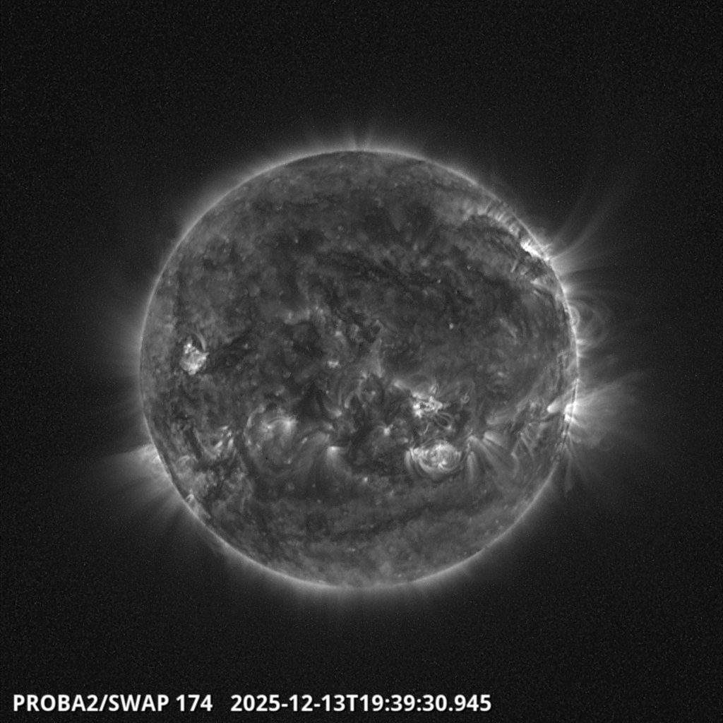
thanks, now its up to you to observe. the sun has indeed rotated over itself, and there in a 2 week and 4 week period of concern, earth must align with the new position. it appears this is the first of two reversals. the next to be observed over a 3 month to 4 month period. in my observation the sun will remain active over 60 to 80 days and show continued signs of magnetic, and rotational realignments. king tides will proof given effects over time. breaking point for Atlantic ocean has begun, some moderate quakes have given some validation. volcanic eruptions are under stress, and pressure. angular momentum, eddy currents.
these results are ongoing over a 4 year period. but this magnetic field reversal points to a second third, and fourth before we can truly say external forces are no longer an effect of induction.
 :dodgy:
these results are ongoing over a 4 year period. but this magnetic field reversal points to a second third, and fourth before we can truly say external forces are no longer an effect of induction.
:dodgy:Again, we have a name at the bottom of the article, just remember it was all a lie to begin with.perhaps this gives ice age model validation ! cheers..
Earth-Size Planet Found In The 'Habitable Zone' of Another Star
April 17, 2014: Using NASA's Kepler Space Telescope, astronomers have discovered the first Earth-size planet orbiting in the "habitable zone" of another star. The planet, named "Kepler-186f" orbits an M dwarf, or red dwarf, a class of stars that makes up 70 percent of the stars in the Milky Way galaxy. The discovery of Kepler-186f confirms that planets the size of Earth exist in the habitable zone of stars other than our sun.
The "habitable zone" is defined as the range of distances from a star where liquid water might pool on the surface of an orbiting planet. While planets have previously been found in the habitable zone, the previous finds are all at least 40 percent larger in size than Earth and understanding their makeup is challenging. Kepler-186f is more reminiscent of Earth.
splash
The artist's concept depicts Kepler-186f , the first validated Earth-size planet to orbit a distant star in the habitable zone. More
Kepler-186f orbits its parent M dwarf star once every 130-days and receives one-third the energy that Earth gets from the sun, placing it nearer the outer edge of the habitable zone. On the surface of Kepler-186f, the brightness of its star at high noon is only as bright as our sun appears to us about an hour before sunset.
Auroras Underfoot (signup)
"M dwarfs are the most numerous stars," said Elisa Quintana, research scientist at the SETI Institute at NASA's Ames Research Center in Moffett Field, Calif., and lead author of the paper published today in the journal Science. "The first signs of other life in the galaxy may well come from planets orbiting an M dwarf."
However, "being in the habitable zone does not mean we know this planet is habitable," cautions Thomas Barclay, a research scientist at the Bay Area Environmental Research Institute at Ames, and co-author of the paper. "The temperature on the planet is strongly dependent on what kind of atmosphere the planet has. Kepler-186f can be thought of as an Earth-cousin rather than an Earth-twin. It has many properties that resemble Earth."
Kepler-186f resides in the Kepler-186 system, about 500 light-years from Earth in the constellation Cygnus. The system is also home to four companion planets: Kepler-186b, Kepler-186c, Kepler-186d, and Kepler-186e, whiz around their sun every four, seven, 13, and 22 days, respectively, making them too hot for life as we know it. These four inner planets all measure less than 1.5 times the size of Earth.
splash
The diagram compares the planets of our inner solar system to Kepler-186, a five-planet star system about 500 light-years from Earth in the constellation Cygnus. More
Although the size of Kepler-186f is known, its mass and composition are not. Previous research, however, suggests that a planet the size of Kepler-186f is likely to be rocky.
"The discovery of Kepler-186f is a significant step toward finding worlds like our planet Earth," said Paul Hertz, NASA's Astrophysics Division director at the agency's headquarters in Washington.
The next steps in the search for distant life include looking for true Earth-twins -- Earth-size planets orbiting within the habitable zone of a sun-like star -- and measuring the their chemical compositions. The Kepler Space Telescope, which simultaneously and continuously measured the brightness of more than 150,000 stars, is NASA's first mission capable of detecting Earth-size planets around stars like our sun.
Looking ahead, Hertz said, "future NASA missions, like the Transiting Exoplanet Survey Satellite and the James Webb Space Telescope, will discover the nearest rocky exoplanets and determine their composition and atmospheric conditions, continuing humankind's quest to find truly Earth-like worlds."
Credits:
Production editor: Dr. Tony Phillips | Credit: Science@NASA
More information:
Ames is responsible for Kepler's ground system development, mission operations, and science data analysis. NASA's Jet Propulsion Laboratory in Pasadena, Calif., managed Kepler mission development. Ball Aerospace & Technologies Corp. in Boulder, Colo., developed the Kepler flight system and supports mission operations with the Laboratory for Atmospheric and Space Physics at the University of Colorado in Boulder. The Space Telescope Science Institute in Baltimore archives, hosts and distributes Kepler science data. Kepler is NASA's 10th Discovery Mission and was funded by the agency's Science Mission Directorate.
The SETI Institute is a private, nonprofit organization dedicated to scientific research, education and public outreach. The mission of the SETI Institute is to explore, understand and explain the origin, nature and prevalence of life in the universe.
https://www.youtube.com/watch?v=BUHOy8KhgEk#t=288
theory of star mass, and life cycle. i had said the sun is sweeping through space. if in fact over time it is pushed into a pocket of debri it may grow.
suns can grow by sweeping up material, as increasing magnetic fields occur, stars are sweeping the arms of the galaxy.
it is very disturbing this relation of great quake on june 23 2014. one moth after the may 23 great quake.. logic tells us a 7.0 or greater is assumed as a pre-curser... this 8.0 may be this curse. one or more 7.o quakes should have been produced. as i link earths expansion with inductive forces.
if the data is off or goes unreported the information provided by this model woulld assume at the very least a clue as to what may follow..

This Hubble image was recorded using polarizing filters (analogous to polarized sunglasses) and color-coded by the angle associated with the polarized light.
the birthing of a star factory.. a cooling of space,
freethisone
Re: Theory, my chalk board.
« Reply #130, on August 12th, 2014, 08:11 AM »Last edited on August 12th, 2014, 08:18 AM
what has Ice age model predicted to date and had also verified?
A list of cause and effects, and the time line to date. aug-12-2014
induction on a large scale, volcanic eruption
planetary miss alignments , red shift.
earthquake prediction, effect of tourque times delta T
angular momentum changes on earth rotation. miss aligned pole positions.
magnetic anomoly air plains crash
rare faction of atomospher ozone production scary lightning
]
Europe flooding sever rain, and mass floods continue
predicting great quakes with a high degree of accuarcy.
plates moving to the east.
tidal surges.
severe super storms.
the sun is directly west at sunset, should be farther north.
add more
http://en.wikipedia.org/wiki/Black_Sun_(occult_symbol)
#mediaviewer/File:Black_Sun.svg)
https://www.youtube.com/watch?v=D7yZ-7Ym8IA#ws
https://www.youtube.com/watch?v=Esphle_MsXI#ws
printed motor winding.http://laserhacker.com/?p=214
http://www.gizmag.com/local-motors-strati-imts/33846/
"World's first" 3D printed car created and driven by Local Motors
By Stu Robarts
September 17, 2014
https://www.youtube.com/watch?v=D7yZ-7Ym8IA#ws
https://www.youtube.com/watch?v=Esphle_MsXI#ws
printed motor winding.http://laserhacker.com/?p=214
http://www.gizmag.com/local-motors-strati-imts/33846/
"World's first" 3D printed car created and driven by Local Motors
By Stu Robarts
September 17, 2014
freethisone
Re: Theory, my chalk board.
« Reply #132, on September 29th, 2014, 06:59 PM »Last edited on September 29th, 2014, 07:02 PM
Black Sun (occult symbol)
From Wikipedia, the free encyclopedia
For other uses, see Black Sun (disambiguation).
A depiction of the "Black Sun" the design of which is based primarily on the shape of the Wewelsburg sunwheel mosaic in the "Obergruppenführer"-Hall (SS Generals' Hall).
The former SS Generals' Hall (German: "Obergruppenführersaal") on the first floor of the North Tower of Wewelsburg Castle with the dark green sun wheel mosaic located on the floor in the center of the hall. Since 1991, occasionally the marble inlay has been called the "Black Sun" - especially by right-wing authors. Since then, the mosaic has been linked to esoteric concepts about a "Black Sun" which have been discussed by neo-nazi circles since the post-war years. The architects who redesigned the castle during the Nazi era called the axis of the North Tower the "Center of the World".
The term Black Sun (German Schwarze Sonne), also referred to as the Sonnenrad (the German for "Sun Wheel"), is a symbol of esoteric and occult significance. Its design is based on a sun wheel mosaic incorporated into a floor of Wewelsburg Castle during the Nazi era. Today, it may also be used in occult currents of Germanic neopaganism, and in Irminenschaft or Armanenschaft-inspired esotericism—but not necessarily in a racial or neo-Nazi context. Despite its contemporary use, the Black Sun had not been identified with the ornament in Wewelsburg before 1991, although it had been discussed as an esoteric concept in neo-Nazi circles since the 1950s.[1]
https://www.youtube.com/watch?v=D7yZ-7Ym8IA#ws
#mediaviewer/File:SchwarzeSonneArtifacts.JPG)
From Wikipedia, the free encyclopedia
For other uses, see Black Sun (disambiguation).
A depiction of the "Black Sun" the design of which is based primarily on the shape of the Wewelsburg sunwheel mosaic in the "Obergruppenführer"-Hall (SS Generals' Hall).
The former SS Generals' Hall (German: "Obergruppenführersaal") on the first floor of the North Tower of Wewelsburg Castle with the dark green sun wheel mosaic located on the floor in the center of the hall. Since 1991, occasionally the marble inlay has been called the "Black Sun" - especially by right-wing authors. Since then, the mosaic has been linked to esoteric concepts about a "Black Sun" which have been discussed by neo-nazi circles since the post-war years. The architects who redesigned the castle during the Nazi era called the axis of the North Tower the "Center of the World".
The term Black Sun (German Schwarze Sonne), also referred to as the Sonnenrad (the German for "Sun Wheel"), is a symbol of esoteric and occult significance. Its design is based on a sun wheel mosaic incorporated into a floor of Wewelsburg Castle during the Nazi era. Today, it may also be used in occult currents of Germanic neopaganism, and in Irminenschaft or Armanenschaft-inspired esotericism—but not necessarily in a racial or neo-Nazi context. Despite its contemporary use, the Black Sun had not been identified with the ornament in Wewelsburg before 1991, although it had been discussed as an esoteric concept in neo-Nazi circles since the 1950s.[1]
https://www.youtube.com/watch?v=D7yZ-7Ym8IA#ws
I say occult is a Astronomy term refer to the black sun. Black sun blots out the sun (sol). this = the occult.. cheers.
fist 4 years of substantial data obtained.
Updated: 2014-10-14 01:39:41 UTC-04:00Showing event times using Local System Time (UTC-04:00)845 earthquakes in map area
6.1 South of the Kermadec Islands 2014-10-14 00:12:30 UTC-04:0031.5 km
7.3 67km WSW of Jiquilillo, Nicaragua 2014-10-13 23:51:35 UTC-04:0040.0 km
6.3 154km ENE of Hachinohe, Japan 2014-10-10 22:35:46 UTC-04:0013.5 km
6.6 Southern East Pacific Rise 2014-10-08 22:32:05 UTC-04:0010.0 km
7.1 Southern East Pacific Rise 2014-10-08 22:14:32 UTC-04:0015.5 km
6.2 121km WSW of El Dorado, Mexico 2014-10-07 22:40:54 UTC-04:0010.0 km
6.0 22km WSW of Weiyuan, China 2014-10-07 09:49:40 UTC-04:0010.9 km
6.2 94km WNW of Willow, Alaska 2014-09-25 13:51:17 UTC-04:00108.9 km
6.0 160km SSW of Gizo, Solomon Islands 2014-09-25 05:13:50 UTC-04:0010.0 km
6.2 46km NNW of San Antonio de los Cobres, Argentina 2014-09-24 07:16:12 UTC-04:00189.3 km
6.7 45km NW of Piti Village, Guam 2014-09-17 02:14:46 UTC-04:00136.7 km
6.2 132km SE of Modayag, Indonesia 2014-09-09 22:46:06 UTC-04:0035.0 km
6.2 230km SW of Tomatlan, Mexico 2014-09-06 15:22:57 UTC-04:0010.0 km
6.1 Easter Island region 2014-09-06 02:53:11 UTC-04:007.0 km
6.0 168km E of `Ohonua, Tonga 2014-09-04 01:33:50 UTC-04:0035.0 km
6.8 43km ENE of Tambo, Peru 2014-08-24 19:21:45 UTC-04:00101.0 km
6.0 6km NW of American Canyon, California 2014-08-24 06:20:44 UTC-04:0011.3 km
6.4 23km WNW of Hacienda La Calera, Chile 2014-08-23 18:32:23 UTC-04:0032.0 km
6.0 42km ESE of Dehloran, Iran 2014-08-18 14:08:22 UTC-04:005.0 km
6.2 40km E of Dehloran, Iran 2014-08-17 22:32:05 UTC-04:0010.2 km
6.1 78km E of Mutsu, Japan 2014-08-09 23:43:17 UTC-04:0041.0 km
6.2 Kepulauan Barat Daya, Indonesia 2014-08-06 07:45:22 UTC-04:0010.0 km
6.2 11km W of Wenping, China 2014-08-03 04:30:13 UTC-04:0012.0 km
6.9 Federated States of Micronesia region 2014-08-02 20:22:03 UTC-04:0013.0 km
6.0 164km SSW of Lorengau, Papua New Guinea 2014-07-29 09:27:40 UTC-04:009.8 km
6.3 24km SE of Playa Vicente, Mexico 2014-07-29 06:46:15 UTC-04:00117.1 km
6.6 Northern Mid-Atlantic Ridge 2014-07-26 21:28:38 UTC-04:0020.0 km
6.0 Northern Mid-Atlantic Ridge 2014-07-26 21:28:37 UTC-04:0010.0 km
6.1 70km WSW of Gustavus, Alaska 2014-07-25 06:54:49 UTC-04:001.0 km
6.9 99km NNE of Ndoi Island, Fiji 2014-07-21 10:54:41 UTC-04:00615.4 km
6.2 96km SE of Kuril'sk, Russia 2014-07-20 14:32:47 UTC-04:0061.0 km
6.0 Owen Fracture Zone region 2014-07-19 10:14:01 UTC-04:0010.0 km
6.2 76km W of Hihifo, Tonga 2014-07-19 08:27:10 UTC-04:00227.3 km
6.0 90km NNW of Yakutat, Alaska 2014-07-17 07:49:33 UTC-04:0010.0 km
6.3 78km SSE of Pondaguitan, Philippines 2014-07-14 03:59:57 UTC-04:0020.0 km
6.5 139km E of Iwaki, Japan 2014-07-11 15:22:00 UTC-04:0020.0 km
6.2 9km ENE of Port-Vila, Vanuatu 2014-07-08 08:56:25 UTC-04:00110.2 km
6.9 4km W of Puerto Madero, Mexico 2014-07-07 07:23:54 UTC-04:0053.0 km
6.0 86km SE of Sinabang, Indonesia 2014-07-05 05:39:27 UTC-04:0020.0 km
6.5 196km S of Taron, Papua New Guinea 2014-07-04 11:00:27 UTC-04:0020.0 km
6.3 193km SE of Raoul Island, New Zealand 2014-07-03 15:50:07 UTC-04:0035.0 km
6.0 Balleny Islands region 2014-07-02 01:53:29 UTC-04:0010.0 km
6.2 Bonin Islands, Japan region 2014-06-30 15:55:32 UTC-04:00511.0 km
6.7 201km SSE of Mata-Utu, Wallis and Futuna 2014-06-29 13:15:09 UTC-04:0018.0 km
6.4 193km SSE of Mata-Utu, Wallis and Futuna 2014-06-29 11:52:23 UTC-04:009.0 km
6.0 159km NNW of Visokoi Island, 2014-06-29 10:32:49 UTC-04:0010.0 km
6.9 154km NNW of Visokoi Island, 2014-06-29 03:52:55 UTC-04:008.0 km
6.2 138km ESE of Iwo Jima, Japan 2014-06-29 01:56:31 UTC-04:0048.0 km
6.3 55km ESE of Buldir Island, Alaska 2014-06-23 23:15:35 UTC-04:004.0 km
6.0 5km ENE of Little Sitkin Island, Alaska 2014-06-23 18:29:51 UTC-04:00106.6 km
6.0 5km WSW of Little Sitkin Island, Alaska 2014-06-23 17:30:46 UTC-04:00101.9 km
6.0 3km WNW of Little Sitkin Island, Alaska 2014-06-23 17:11:40 UTC-04:00102.9 km
7.9 19km SE of Little Sitkin Island, Alaska 2014-06-23 16:53:09 UTC-04:00109.0 km
6.7 79km SSE of Raoul Island, New Zealand 2014-06-23 16:06:20 UTC-04:0026.6 km
6.5 83km SSE of Raoul Island, New Zealand 2014-06-23 15:21:45 UTC-04:0010.0 km
6.9 80km SSE of Raoul Island, New Zealand 2014-06-23 15:19:15 UTC-04:0020.0 km
6.2 85km WNW of Sola, Vanuatu 2014-06-19 06:17:55 UTC-04:0036.0 km
6.5 South Indian Ocean 2014-06-14 07:10:59 UTC-04:004.0 km
6.2 265km WSW of Tomatlan, Mexico 2014-05-31 07:53:46 UTC-04:005.0 km
6.9 22km SSW of Kamariotissa, Greece 2014-05-24 05:25:02 UTC-04:006.4 km
6.0 276km SE of Konarka, India 2014-05-21 12:21:54 UTC-04:0047.2 km
6.0 Off the west coast of northern Sumatra 2014-05-17 21:02:32 UTC-04:0035.0 km
6.3 51km WSW of Alim, Philippines 2014-05-15 06:16:42 UTC-04:0015.5 km
6.3 106km SSE of Ifalik, Micronesia 2014-05-15 04:16:34 UTC-04:0011.0 km
6.1 103km SSE of Ifalik, Micronesia 2014-05-14 16:56:13 UTC-04:0010.0 km
6.5 110km SE of Punta de Burica, Panama 2014-05-13 02:35:24 UTC-04:0010.0 km
6.5 Southern East Pacific Rise 2014-05-12 14:38:36 UTC-04:0010.5 km
6.0 14km WSW of Tecpan de Galeana, Mexico 2014-05-10 03:36:01 UTC-04:0023.0 km
6.4 6km WSW of Tecpan de Galeana, Mexico 2014-05-08 13:00:14 UTC-04:0017.1 km
6.0 96km SW of Panguna, Papua New Guinea 2014-05-07 00:20:33 UTC-04:0010.0 km
6.3 West Chile Rise 2014-05-06 16:52:28 UTC-04:0016.8 km
6.1 13km NNW of Phan, Thailand 2014-05-05 07:08:43 UTC-04:006.0 km
6.0 31km E of Ito, Japan 2014-05-04 16:18:24 UTC-04:00153.0 km
6.3 South of the Fiji Islands 2014-05-04 05:25:15 UTC-04:00634.2 km
6.6 South of the Fiji Islands 2014-05-04 05:15:52 UTC-04:00527.0 km
6.6 204km WNW of Ile Hunter, New Caledonia 2014-05-01 02:36:35 UTC-04:00106.0 km
6.1 66km NE of Nuku`alofa, Tonga 2014-04-26 02:02:21 UTC-04:0045.0 km
6.5 120km S of Port Hardy, Canada 2014-04-23 23:10:10 UTC-04:0010.0 km
6.2 95km S of Panguna, Papua New Guinea 2014-04-19 20:15:58 UTC-04:0020.0 km
7.5 70km SW of Panguna, Papua New Guinea 2014-04-19 09:28:00 UTC-04:0043.4 km
6.6 57km SW of Panguna, Papua New Guinea 2014-04-18 21:04:03 UTC-04:0029.0 km
7.2 Guerrero, Mexico 2014-04-18 10:27:24 UTC-04:0024.0 km
6.1 120km WSW of Lata, Solomon Islands 2014-04-18 00:13:12 UTC-04:0010.0 km
6.2 Balleny Islands region 2014-04-17 11:06:51 UTC-04:0020.6 km
6.8 Bouvet Island region 2014-04-14 23:57:01 UTC-04:0011.2 km
6.6 75km S of Kirakira, Solomon Islands 2014-04-13 09:24:59 UTC-04:0010.0 km
7.4 112km S of Kirakira, Solomon Islands 2014-04-13 08:36:19 UTC-04:0039.0 km
7.6 93km SSE of Kirakira, Solomon Islands 2014-04-12 16:14:39 UTC-04:0022.6 km
6.1 91km SSW of Panguna, Papua New Guinea 2014-04-12 01:24:23 UTC-04:0020.0 km
6.6 15km N of Belen, Nicaragua 2014-04-11 16:29:12 UTC-04:00135.0 km
6.5 78km SW of Panguna, Papua New Guinea 2014-04-11 04:16:45 UTC-04:0020.0 km
7.1 56km WSW of Panguna, Papua New Guinea 2014-04-11 03:07:23 UTC-04:0060.5 km
6.2 72km SW of Iquique, Chile 2014-04-10 20:01:45 UTC-04:0013.8 km
6.1 16km SW of Valle San Francisco, Nicaragua 2014-04-10 19:27:45 UTC-04:0013.0 km
6.0 25km WSW of Kirakira, Solomon Islands 2014-04-04 07:40:32 UTC-04:0057.0 km
6.3 70km SW of Iquique, Chile 2014-04-03 21:37:50 UTC-04:0013.7 km
6.4 78km SW of Iquique, Chile 2014-04-03 01:26:15 UTC-04:0025.0 km
7.7 53km SW of Iquique, Chile 2014-04-02 22:43:13 UTC-04:0022.4 km
6.5 46km WSW of Iquique, Chile 2014-04-02 21:58:30 UTC-04:0024.1 km
6.0 48km SSE of Pedregal, Panama 2014-04-02 12:13:26 UTC-04:0025.0 km
6.9 91km WNW of Iquique, Chile 2014-04-01 19:57:58 UTC-04:0028.4 km
8.2 94km NW of Iquique, Chile 2014-04-01 19:46:47 UTC-04:0025.0 km
6.0 173km SSE of Lata, Solomon Islands 2014-03-26 23:49:42 UTC-04:0098.0 km
6.3 South of the Fiji Islands 2014-03-25 23:29:35 UTC-04:00495.0 km
6.3 94km NW of Iquique, Chile 2014-03-23 14:20:01 UTC-04:0021.0 km
6.2 91km WNW of Iquique, Chile 2014-03-22 08:59:59 UTC-04:0020.0 km
6.4 114km ESE of Mohean, India 2014-03-21 09:41:09 UTC-04:0021.5 km
6.4 80km WNW of Iquique, Chile 2014-03-17 01:11:34 UTC-04:0021.0 km
6.7 64km WNW of Iquique, Chile 2014-03-16 17:16:29 UTC-04:0020.0 km
6.3 16km W of Sechura, Peru 2014-03-15 19:51:32 UTC-04:0029.0 km
6.1 24km S of Paracas, Peru 2014-03-15 04:59:21 UTC-04:0020.0 km
6.3 15km NNE of Kunisaki-shi, Japan 2014-03-13 13:06:50 UTC-04:0079.0 km
6.1 184km SE of Lorengau, Papua New Guinea 2014-03-11 18:03:09 UTC-04:007.0 km
6.4 East of the South Sandwich Islands 2014-03-10 22:44:05 UTC-04:0010.0 km
6.8 78km WNW of Ferndale, California 2014-03-10 01:18:13 UTC-04:0016.6 km
6.3 262km ESE of Sola, Vanuatu 2014-03-05 05:56:57 UTC-04:00638.0 km
6.0 98km SW of Puerto Madero, Mexico 2014-03-02 18:17:14 UTC-04:0018.5 km
6.5 111km NNW of Nago, Japan 2014-03-02 16:11:23 UTC-04:00119.0 km
6.2 33km SW of Jiquilillo, Nicaragua 2014-03-02 05:37:54 UTC-04:0060.0 km
6.1 129km NNW of Amukta Island, Alaska 2014-02-26 17:13:40 UTC-04:00265.0 km
6.5 172km NNE of Bathsheba, Barbados 2014-02-18 05:27:13 UTC-04:0014.8 km
6.9 272km ESE of Hotan, China 2014-02-12 05:19:49 UTC-04:0010.0 km
6.0 122km WNW of Panguna, Papua New Guinea 2014-02-09 10:56:39 UTC-04:0041.8 km
6.5 34km E of Port-Olry, Vanuatu 2014-02-07 04:40:13 UTC-04:00122.0 km
6.0 7km NNW of Lixourion, Greece 2014-02-02 23:08:46 UTC-04:005.0 km
6.5 189km SSE of L'Esperance Rock, New Zealand 2014-02-02 05:26:37 UTC-04:0044.3 km
6.1 16km SSW of Visokoi Island, 2014-01-31 23:58:43 UTC-04:00130.0 km
6.1 1km ENE of Lixourion, Greece 2014-01-26 09:55:42 UTC-04:008.0 km
6.1 38km SSE of Adipala, Indonesia 2014-01-25 01:14:18 UTC-04:0066.0 km
6.1 133km NW of Hihifo, Tonga 2014-01-20 21:29:07 UTC-04:006.1 km
6.1 35km NNE of Masterton, New Zealand 2014-01-19 22:52:44 UTC-04:0028.0 km
6.4 61km N of Hatillo, Puerto Rico 2014-01-13 00:01:03 UTC-04:0020.0 km
6.5 32km W of Sola, Vanuatu 2014-01-01 12:03:29 UTC-04:00187.0 km
6.2 198km E of Farallon de Pajaros, Northern Mariana Islands 2013-12-17 19:38:06 UTC-04:009.0 km
6.0 134km SE of Kuril'sk, Russia 2013-12-08 13:24:54 UTC-04:0028.0 km
6.0 69km SE of Sinabang, Indonesia 2013-12-01 02:29:57 UTC-04:0020.0 km
6.4 Kepulauan Barat Daya, Indonesia 2013-11-30 21:24:13 UTC-04:009.9 km
6.0 South Atlantic Ocean 2013-11-25 03:21:18 UTC-04:0014.8 km
7.0 Falkland Islands region 2013-11-25 02:27:33 UTC-04:0011.8 km
6.0 247km E of Kuril'sk, Russia 2013-11-25 01:56:50 UTC-04:0034.0 km
6.5 Fiji region 2013-11-23 03:48:32 UTC-04:00371.0 km
6.0 58km WSW of Agrihan, Northern Mariana Islands 2013-11-19 13:00:44 UTC-04:00511.0 km
6.0 111km NNE of Tobelo, Indonesia 2013-11-19 09:32:51 UTC-04:0038.0 km
7.7 Scotia Sea 2013-11-17 05:04:55 UTC-04:0010.0 km
6.9 Scotia Sea 2013-11-15 23:34:31 UTC-04:0010.0 km
6.1 Scotia Sea 2013-11-13 19:45:47 UTC-04:0011.1 km
6.4 172km S of Ust'-Kamchatsk Staryy, Russia 2013-11-12 03:03:51 UTC-04:0043.0 km
6.2 152km ESE of Neiafu, Tonga 2013-11-02 14:53:46 UTC-04:0010.1 km
6.0 Easter Island region 2013-11-02 11:52:46 UTC-04:0010.0 km
6.6 41km SSW of Coquimbo, Chile 2013-10-31 19:03:59 UTC-04:0027.0 km
6.3 46km SSW of Hualian, Taiwan 2013-10-31 08:02:08 UTC-04:0010.0 km
6.2 88km W of Constitucion, Chile 2013-10-29 22:51:47 UTC-04:0041.5 km
7.1 Off the east coast of Honshu, Japan 2013-10-25 13:10:19 UTC-04:0035.0 km
6.7 East of the South Sandwich Islands 2013-10-24 15:25:10 UTC-04:0022.9 km
6.0 283km SW of Vaini, Tonga 2013-10-23 04:23:30 UTC-04:00160.0 km
6.6 99km SW of Etchoropo, Mexico 2013-10-19 13:54:54 UTC-04:009.5 km
6.8 62km WSW of Panguna, Papua New Guinea 2013-10-16 06:30:58 UTC-04:0035.0 km
7.1 4km SE of Sagbayan, Philippines 2013-10-14 20:12:32 UTC-04:0019.0 km
6.6 31km W of Platanos, Greece 2013-10-12 09:11:53 UTC-04:0040.0 km
6.0 36km N of Gueiria, Venezuela 2013-10-11 22:10:27 UTC-04:0063.0 km
6.2 94km NNE of L'Esperance Rock, New Zealand 2013-10-11 17:25:00 UTC-04:00151.0 km
6.2 West Chile Rise 2013-10-06 17:33:19 UTC-04:0010.3 km
6.0 Mariana Islands region 2013-10-06 12:38:08 UTC-04:00104.0 km
6.4 113km SE of Amsterdam Island, 2013-10-04 13:26:13 UTC-04:0012.7 km
6.7 Sea of Okhotsk 2013-09-30 23:38:21 UTC-04:00573.0 km
6.5 78km NE of L'Esperance Rock, New Zealand 2013-09-30 01:55:55 UTC-04:0041.5 km
6.8 85km NNE of Awaran, Pakistan 2013-09-28 03:34:06 UTC-04:0012.0 km
7.1 46km SSE of Acari, Peru 2013-09-25 12:42:43 UTC-04:0040.0 km
6.1 Southern East Pacific Rise 2013-09-25 02:51:24 UTC-04:0010.0 km
7.7 61km NNE of Awaran, Pakistan 2013-09-24 07:29:47 UTC-04:0015.0 km
6.1 111km NNW of Nggilat, Indonesia 2013-09-20 21:39:15 UTC-04:00549.9 km
6.1 77km SSW of Atka, Alaska 2013-09-15 12:21:37 UTC-04:0024.0 km
6.1 Central East Pacific Rise 2013-09-11 08:44:13 UTC-04:0010.5 km
6.4 7km SSE of Ciudad Tecun Uman, Guatemala 2013-09-06 20:13:29 UTC-04:0066.0 km
6.0 Northern Mid-Atlantic Ridge 2013-09-05 00:01:36 UTC-04:0010.0 km
6.0 82km SSW of Atka, Alaska 2013-09-04 02:27:03 UTC-04:0017.0 km
6.5 81km SSW of Atka, Alaska 2013-09-03 22:32:30 UTC-04:0020.0 km
6.0 182km SW of Bella Bella, Canada 2013-09-03 20:23:11 UTC-04:009.9 km
6.5 Izu Islands, Japan region 2013-09-03 20:18:23 UTC-04:00402.0 km
6.1 187km WSW of Bella Bella, Canada 2013-09-03 16:19:06 UTC-04:002.7 km
6.5 Kepulauan Barat Daya, Indonesia 2013-09-01 07:52:29 UTC-04:00112.0 km
6.0 118km SSW of Atka, Alaska 2013-08-31 02:38:36 UTC-04:0018.0 km
7.0 101km SW of Atka, Alaska 2013-08-30 12:25:02 UTC-04:0029.0 km
6.2 292km NW of Raoul Island, New Zealand 2013-08-27 22:54:41 UTC-04:00478.0 km
6.2 18km WNW of San Marcos, Mexico 2013-08-21 08:38:29 UTC-04:0021.0 km
6.1 Southwest Indian Ridge 2013-08-17 12:32:31 UTC-04:0010.0 km
6.5 29km SE of Blenheim, New Zealand 2013-08-15 22:31:05 UTC-04:008.2 km
6.7 101km WSW of Mutis, Colombia 2013-08-13 11:43:15 UTC-04:0012.0 km
6.2 96km WSW of Paita, Peru 2013-08-12 05:49:32 UTC-04:0010.0 km
6.1 116km NW of L'Esperance Rock, New Zealand 2013-08-12 00:16:47 UTC-04:00340.6 km
6.0 189km WNW of Saumlaki, Indonesia 2013-08-11 20:53:43 UTC-04:0095.0 km
6.0 82km NNE of Hihifo, Tonga 2013-08-01 16:01:43 UTC-04:0031.7 km
6.2 199km NE of Bristol Island, South Sandwich Islands 2013-07-26 17:32:59 UTC-04:0013.0 km
6.1 58km ENE of Luganville, Vanuatu 2013-07-26 03:07:15 UTC-04:00124.0 km
6.1 244km WNW of Marion Island, Prince Edward Islands 2013-07-22 03:01:42 UTC-04:0010.0 km
6.5 46km ESE of Blenheim, New Zealand 2013-07-21 01:09:31 UTC-04:0014.0 km
6.0 18km W of Chivay, Peru 2013-07-16 22:37:42 UTC-04:006.6 km
6.0 77km W of Panguna, Papua New Guinea 2013-07-16 05:35:54 UTC-04:0044.3 km
7.3 218km SSE of Bristol Island, South Sandwich Islands 2013-07-15 10:03:43 UTC-04:0031.0 km
6.6 29km NE of Kandrian, Papua New Guinea 2013-07-07 16:30:07 UTC-04:0062.0 km
7.3 115km ENE of Taron, Papua New Guinea 2013-07-07 14:35:30 UTC-04:00386.3 km
6.0 157km SW of Sungaipenuh, Indonesia 2013-07-06 01:05:06 UTC-04:0019.7 km
6.1 81km SSE of Panguna, Papua New Guinea 2013-07-04 13:16:00 UTC-04:0072.0 km
6.1 55km S of Bireun, Indonesia 2013-07-02 03:37:02 UTC-04:0010.0 km
6.6 Northern Mid-Atlantic Ridge 2013-06-24 18:04:13 UTC-04:0010.0 km
6.0 81km S of Pirgos, Greece 2013-06-16 17:39:04 UTC-04:0026.0 km
6.5 46km W of Masachapa, Nicaragua 2013-06-15 13:34:29 UTC-04:0035.8 km
6.2 61km S of Pirgos, Greece 2013-06-15 12:11:00 UTC-04:0010.0 km
6.0 South of the Kermadec Islands 2013-06-15 07:20:36 UTC-04:00195.0 km
6.7 177km ENE of Flying Fish Cove, Christmas Island 2013-06-13 12:47:23 UTC-04:008.6 km
6.1 91km SSE of Lata, Solomon Islands 2013-06-05 00:47:26 UTC-04:0039.0 km
6.2 25km SE of Buli, Taiwan 2013-06-02 01:43:03 UTC-04:0017.0 km
6.7 Sea of Okhotsk 2013-05-24 10:56:31 UTC-04:00623.0 km
8.3 Sea of Okhotsk 2013-05-24 01:44:49 UTC-04:00608.9 km
6.3 86km NW of Nuku`alofa, Tonga 2013-05-23 17:07:46 UTC-04:00149.1 km
7.4 282km SW of Vaini, Tonga 2013-05-23 13:19:04 UTC-04:00171.4 km
6.1 122km SE of Petropavlovsk-Kamchatskiy, Russia 2013-05-21 01:43:21 UTC-04:0036.7 km
6.0 139km ESE of Petropavlovsk-Kamchatskiy, Russia 2013-05-20 21:55:05 UTC-04:0015.1 km
6.4 Off the coast of Aisen, Chile 2013-05-20 05:49:04 UTC-04:0010.0 km
6.0 50km NE of Namie, Japan 2013-05-18 01:47:59 UTC-04:0039.0 km
6.8 40km W of Agrihan, Northern Mariana Islands 2013-05-13 20:32:25 UTC-04:00602.3 km
6.4 140km WNW of Neiafu, Tonga 2013-05-11 16:46:57 UTC-04:00212.2 km
6.1 94km SE of Minab, Iran 2013-05-10 22:08:08 UTC-04:0015.0 km
6.0 239km NNE of Ceva-i-Ra, Fiji 2013-05-07 06:10:55 UTC-04:0070.1 km
6.2 115km WNW of Raoul Island, New Zealand 2013-04-26 02:53:28 UTC-04:00349.0 km
6.1 118km WNW of Raoul Island, New Zealand 2013-04-26 02:53:28 UTC-04:00351.0 km
6.5 31km N of Rabaul, Papua New Guinea 2013-04-23 19:14:42 UTC-04:0023.3 km
6.0 20km NNW of La Union, Mexico 2013-04-21 21:16:33 UTC-04:0030.0 km
6.1 Izu Islands, Japan region 2013-04-20 23:22:16 UTC-04:00421.9 km
6.1 97km SE of Severo-Kuril'sk, Russia 2013-04-20 09:12:50 UTC-04:0018.0 km
6.6 56km WSW of Linqiong, China 2013-04-19 20:02:47 UTC-04:0014.0 km
6.1 135km SE of Severo-Kuril'sk, Russia 2013-04-19 15:58:41 UTC-04:0020.0 km
7.2 251km ENE of Kuril'sk, Russia 2013-04-18 23:05:52 UTC-04:00112.2 km
6.6 23km ESE of Aitape, Papua New Guinea 2013-04-16 18:55:27 UTC-04:0013.0 km
7.7 83km E of Khash, Iran 2013-04-16 06:44:20 UTC-04:0082.0 km
6.6 98km W of Panguna, Papua New Guinea 2013-04-13 21:32:22 UTC-04:0031.0 km
6.0 53km NNE of Isangel, Vanuatu 2013-04-13 18:49:50 UTC-04:00280.2 km
6.4 89km SE of Bandar Bushehr, Iran 2013-04-09 07:52:50 UTC-04:0010.0 km
7.0 240km E of Enarotali, Indonesia 2013-04-06 00:42:35 UTC-04:0066.0 km
6.3 9km N of Zarubino, Russia 2013-04-05 09:00:02 UTC-04:00561.9 km
6.0 108km E of Miyako, Japan 2013-04-01 14:53:18 UTC-04:0020.9 km
6.2 6km ENE of Santa Catarina Pinula, Guatemala 2013-03-25 19:02:13 UTC-04:00189.0 km
6.1 167km NW of Ceva-i-Ra, Fiji 2013-03-24 04:13:45 UTC-04:0010.0 km
6.5 32km E of Finschhafen, Papua New Guinea 2013-03-10 18:51:51 UTC-04:0028.9 km
6.5 89km SE of Ozernovskiy, Russia 2013-03-01 09:20:50 UTC-04:0029.0 km
6.4 93km SE of Ozernovskiy, Russia 2013-03-01 08:53:52 UTC-04:0040.9 km
6.9 84km SE of Ozernovskiy, Russia 2013-02-28 10:05:50 UTC-04:0041.0 km
6.1 23km ESE of Suncho Corral, Argentina 2013-02-22 08:01:59 UTC-04:00585.8 km
6.1 16km SE of Caburan, Philippines 2013-02-16 00:37:36 UTC-04:00105.0 km
6.6 135km WSW of Druzhina, Russia 2013-02-14 09:13:52 UTC-04:009.9 km
6.0 48km WSW of Lata, Solomon Islands 2013-02-10 14:39:32 UTC-04:0011.0 km
6.6 25km S of Lata, Solomon Islands 2013-02-09 17:02:22 UTC-04:0015.6 km
6.9 2km N of Yacuanquer, Colombia 2013-02-09 10:16:07 UTC-04:00145.0 km
7.1 31km SE of Lata, Solomon Islands 2013-02-08 11:26:38 UTC-04:0021.0 km
6.8 21km SSE of Lata, Solomon Islands 2013-02-08 07:12:13 UTC-04:0015.9 km
6.7 36km SSW of Lata, Solomon Islands 2013-02-07 14:59:16 UTC-04:0010.0 km
6.0 142km SW of Lata, Solomon Islands 2013-02-06 20:30:10 UTC-04:008.0 km
6.0 59km S of Lata, Solomon Islands 2013-02-06 07:53:55 UTC-04:0014.0 km
6.0 117km W of Lata, Solomon Islands 2013-02-06 06:33:17 UTC-04:0010.0 km
6.1 144km W of Lata, Solomon Islands 2013-02-06 02:35:19 UTC-04:0010.1 km
7.0 27km NNW of Lata, Solomon Islands 2013-02-05 21:54:15 UTC-04:009.8 km
7.1 114km WSW of Lata, Solomon Islands 2013-02-05 21:23:19 UTC-04:0010.1 km
8.0 76km W of Lata, Solomon Islands 2013-02-05 21:12:27 UTC-04:0028.7 km
6.0 66km WSW of Lata, Solomon Islands 2013-02-05 20:07:22 UTC-04:0012.6 km
6.0 67km WSW of Lata, Solomon Islands 2013-02-02 14:58:05 UTC-04:003.2 km
6.9 19km SSW of Obihiro, Japan 2013-02-02 10:17:35 UTC-04:00107.0 km
6.4 66km SW of Lata, Solomon Islands 2013-02-01 18:18:33 UTC-04:0010.0 km
6.3 53km WSW of Lata, Solomon Islands 2013-02-01 18:16:34 UTC-04:0010.0 km
6.0 53km SW of Lata, Solomon Islands 2013-02-01 01:36:41 UTC-04:0015.0 km
6.1 60km E of Lata, Solomon Islands 2013-01-30 23:33:43 UTC-04:009.2 km
6.1 59km E of Lata, Solomon Islands 2013-01-30 19:03:43 UTC-04:0011.0 km
6.8 56km NNE of Vallenar, Chile 2013-01-30 16:15:43 UTC-04:0045.0 km
6.1 60km SE of Kegen, Kazakhstan 2013-01-28 12:38:53 UTC-04:0015.0 km
6.1 47km SSW of Sigli, Indonesia 2013-01-21 18:22:52 UTC-04:0011.6 km
6.1 Pacific-Antarctic Ridge 2013-01-15 12:09:37 UTC-04:0010.0 km
7.5 Southeastern Alaska 2013-01-05 04:58:19 UTC-04:0010.0 km
6.7 Vanuatu 2012-12-21 18:28:08 UTC-04:00200.7 km
6.1 Sulawesi, Indonesia 2012-12-17 05:16:30 UTC-04:0044.2 km
6.1 New Ireland region, Papua New Guinea 2012-12-15 15:30:02 UTC-04:0052.0 km
6.0 Near Islands, Aleutian Islands, Alaska 2012-12-15 00:49:29 UTC-04:0026.0 km
6.3 off the west coast of Baja California 2012-12-14 06:36:01 UTC-04:0013.0 km
6.0 Molucca Sea 2012-12-11 02:18:27 UTC-04:0030.0 km
7.1 Banda Sea 2012-12-10 12:53:08 UTC-04:00155.0 km
6.3 North Island of New Zealand 2012-12-07 14:19:06 UTC-04:00163.0 km
6.2 off the east coast of Honshu, Japan 2012-12-07 04:31:14 UTC-04:0032.0 km
7.3 off the east coast of Honshu, Japan 2012-12-07 04:18:23 UTC-04:0031.0 km
6.1 Vanuatu 2012-12-01 20:54:22 UTC-04:0032.0 km
6.0 New Britain region, Papua New Guinea 2012-11-19 05:44:34 UTC-04:0013.0 km
6.5 Kuril Islands 2012-11-16 14:12:39 UTC-04:0029.0 km
6.1 Guerrero, Mexico 2012-11-15 05:20:21 UTC-04:0053.0 km
6.1 Coquimbo, Chile 2012-11-14 15:02:06 UTC-04:0063.0 km
6.1 off the coast of Aisen, Chile 2012-11-13 00:31:26 UTC-04:009.0 km
6.3 Gulf of Alaska 2012-11-12 16:42:14 UTC-04:009.0 km
6.5 offshore Guatemala 2012-11-11 18:14:59 UTC-04:0020.0 km
6.8 Myanmar 2012-11-10 21:12:38 UTC-04:0013.7 km
6.0 central Peru 2012-11-10 10:57:50 UTC-04:00129.0 km
6.1 Vancouver Island, Canada region 2012-11-07 22:01:50 UTC-04:0013.7 km
7.4 offshore Guatemala 2012-11-07 12:35:46 UTC-04:0024.0 km
6.1 Mindanao, Philippines 2012-11-02 14:17:32 UTC-04:0037.0 km
6.2 Haida Gwaii, Canada 2012-10-29 22:49:02 UTC-04:009.0 km
6.3 Haida Gwaii, Canada 2012-10-28 14:54:20 UTC-04:009.0 km
7.8 Haida Gwaii, Canada 2012-10-27 23:04:08 UTC-04:0014.0 km
6.5 Costa Rica 2012-10-23 20:45:32 UTC-04:0017.0 km
6.2 Vanuatu 2012-10-20 19:00:32 UTC-04:0036.0 km
6.0 Celebes Sea 2012-10-17 00:42:30 UTC-04:00326.0 km
6.6 near the south coast of Papua, Indonesia 2012-10-11 20:31:28 UTC-04:0013.0 km
6.6 west of Macquarie Island 2012-10-09 08:32:09 UTC-04:0010.0 km
6.1 Banda Sea 2012-10-08 07:43:31 UTC-04:0010.0 km
6.1 off the east coast of Honshu, Japan 2012-10-01 18:21:46 UTC-04:0015.0 km
7.3 Colombia 2012-09-30 12:31:35 UTC-04:00170.0 km
6.4 Andreanof Islands, Aleutian Islands, Alaska 2012-09-26 19:39:55 UTC-04:0016.0 km
6.3 Baja California Sur, Mexico 2012-09-25 19:45:24 UTC-04:0010.0 km
6.2 Kepulauan Mentawai region, Indonesia 2012-09-14 00:51:47 UTC-04:0019.0 km
6.1 Papua, Indonesia 2012-09-08 06:51:44 UTC-04:0021.0 km
7.6 Costa Rica 2012-09-05 10:42:07 UTC-04:0035.0 km
6.0 Santa Cruz Islands 2012-09-05 09:09:10 UTC-04:0027.0 km
6.1 south of Java, Indonesia 2012-09-03 14:23:05 UTC-04:0014.0 km
7.6 Philippine Islands region 2012-08-31 08:47:33 UTC-04:0028.0 km
6.8 Jan Mayen Island region 2012-08-30 09:43:25 UTC-04:0014.0 km
7.3 off the coast of El Salvador 2012-08-27 00:37:19 UTC-04:0028.0 km
6.6 Molucca Sea 2012-08-26 11:05:37 UTC-04:0091.1 km
6.2 near the north coast of New Guinea, Papua New Guinea 2012-08-19 18:41:49 UTC-04:0073.0 km
6.3 Sulawesi, Indonesia 2012-08-18 05:41:52 UTC-04:0010.0 km
7.7 Sea of Okhotsk 2012-08-13 22:59:38 UTC-04:00583.2 km
6.2 Xinjiang-Xizang border region 2012-08-12 06:47:06 UTC-04:0013.0 km
6.2 northwestern Iran 2012-08-11 08:34:35 UTC-04:0012.0 km
6.4 northwestern Iran 2012-08-11 08:23:18 UTC-04:0011.0 km
6.2 Fox Islands, Aleutian Islands, Alaska 2012-08-10 14:37:43 UTC-04:0013.0 km
6.1 New Ireland region, Papua New Guinea 2012-08-02 05:56:41 UTC-04:0046.0 km
6.1 central Peru 2012-08-02 05:38:30 UTC-04:00144.6 km
6.5 New Ireland region, Papua New Guinea 2012-07-28 16:03:56 UTC-04:0041.0 km
6.7 Mauritius - Reunion region 2012-07-26 01:33:33 UTC-04:0020.0 km
6.4 Solomon Islands 2012-07-25 07:20:27 UTC-04:0020.0 km
6.4 Simeulue, Indonesia 2012-07-24 20:27:45 UTC-04:0022.0 km
6.0 Kuril Islands 2012-07-20 02:10:25 UTC-04:0019.0 km
6.0 Kuril Islands 2012-07-08 07:33:02 UTC-04:0020.0 km
6.3 Vanuatu 2012-07-05 22:28:22 UTC-04:00160.1 km
6.3 Cook Strait, New Zealand 2012-07-03 06:36:15 UTC-04:00229.8 km
6.3 northern Xinjiang, China 2012-06-29 17:07:33 UTC-04:0018.0 km
6.0 near the east coast of the Kamchatka Peninsula, Russia 2012-06-23 23:15:01 UTC-04:0010.0 km
6.1 northern Sumatra, Indonesia 2012-06-23 00:34:53 UTC-04:0095.0 km
6.0 Near Islands, Aleutian Islands, Alaska 2012-06-19 11:56:32 UTC-04:0014.0 km
6.3 near the east coast of Honshu, Japan 2012-06-17 16:32:20 UTC-04:0036.0 km
6.0 Dodecanese Islands, Greece 2012-06-10 08:44:16 UTC-04:0035.0 km
6.1 southern Peru 2012-06-07 12:03:18 UTC-04:00110.0 km
6.0 Maule, Chile 2012-06-07 00:05:04 UTC-04:008.0 km
6.1 off the east coast of Honshu, Japan 2012-06-05 15:31:33 UTC-04:0015.0 km
6.3 south of Panama 2012-06-03 23:15:24 UTC-04:007.0 km
6.3 south of Panama 2012-06-03 20:45:15 UTC-04:007.0 km
6.7 Santiago Del Estero, Argentina 2012-05-28 01:07:23 UTC-04:00586.9 km
6.0 Bonin Islands, Japan region 2012-05-26 17:48:10 UTC-04:00487.4 km
6.1 Norwegian Sea 2012-05-24 18:47:46 UTC-04:0010.0 km
6.0 western Indian-Antarctic Ridge 2012-05-23 18:59:52 UTC-04:0010.0 km
6.3 off the east coast of Honshu, Japan 2012-05-20 03:20:36 UTC-04:0011.0 km
6.0 northern Italy 2012-05-19 22:03:52 UTC-04:006.3 km
6.3 off the coast of Aisen, Chile 2012-05-17 22:00:39 UTC-04:0010.0 km
6.2 Tarapaca, Chile 2012-05-14 06:00:40 UTC-04:00105.9 km
6.0 offshore Chiapas, Mexico 2012-05-01 18:43:33 UTC-04:0014.0 km
6.6 Tonga 2012-04-28 06:08:08 UTC-04:00134.7 km
6.0 Kermadec Islands region 2012-04-23 13:36:21 UTC-04:00114.0 km
6.0 near the north coast of Papua, Indonesia 2012-04-20 21:25:13 UTC-04:0017.4 km
6.7 near the north coast of Papua, Indonesia 2012-04-20 21:16:52 UTC-04:0016.0 km
6.2 east of the South Sandwich Islands 2012-04-17 15:03:56 UTC-04:0012.0 km
6.8 eastern New Guinea region, Papua New Guinea 2012-04-17 03:13:49 UTC-04:00198.0 km
6.7 Valparaiso, Chile 2012-04-16 23:50:15 UTC-04:0029.0 km
6.2 off the west coast of northern Sumatra 2012-04-15 01:57:40 UTC-04:0025.0 km
6.2 Vanuatu 2012-04-14 18:05:26 UTC-04:0011.0 km
6.2 Drake Passage 2012-04-14 06:56:19 UTC-04:0015.0 km
7.0 Baja California, Mexico 2012-04-12 03:15:48 UTC-04:0013.0 km
6.0 Baja California, Mexico 2012-04-12 03:06:00 UTC-04:009.0 km
6.5 Michoacan, Mexico 2012-04-11 18:55:10 UTC-04:0020.0 km
6.0 off the coast of Oregon 2012-04-11 18:41:46 UTC-04:008.0 km
8.2 off the west coast of northern Sumatra 2012-04-11 06:43:10 UTC-04:0025.1 km
6.0 North Indian Ocean 2012-04-11 05:27:56 UTC-04:0010.0 km
8.6 off the west coast of northern Sumatra 2012-04-11 04:38:36 UTC-04:0020.0 km
6.1 New Ireland region, Papua New Guinea 2012-04-06 12:15:58 UTC-04:00108.5 km
6.0 Oaxaca, Mexico 2012-04-02 13:36:42 UTC-04:009.0 km
6.1 near the east coast of Honshu, Japan 2012-03-27 07:00:44 UTC-04:0015.0 km
6.0 northern East Pacific Rise 2012-03-26 14:12:52 UTC-04:0010.0 km
7.1 Maule, Chile 2012-03-25 18:37:06 UTC-04:0040.7 km
6.6 New Guinea, Papua New Guinea 2012-03-21 18:15:06 UTC-04:00118.0 km
7.4 Oaxaca, Mexico 2012-03-20 14:02:47 UTC-04:0020.0 km
6.1 Papua, Indonesia 2012-03-20 13:56:18 UTC-04:0066.0 km
6.2 New Britain region, Papua New Guinea 2012-03-14 17:13:08 UTC-04:0028.0 km
6.0 near the east coast of Honshu, Japan 2012-03-14 08:05:04 UTC-04:0010.0 km
6.1 off the east coast of Honshu, Japan 2012-03-14 06:49:24 UTC-04:0010.0 km
6.9 off the east coast of Honshu, Japan 2012-03-14 05:08:35 UTC-04:0012.0 km
6.7 Vanuatu 2012-03-09 03:09:50 UTC-04:0016.0 km
6.1 Santiago Del Estero, Argentina 2012-03-05 03:46:10 UTC-04:00553.9 km
6.6 southeast of the Loyalty Islands 2012-03-03 08:19:55 UTC-04:0014.0 km
6.7 southwestern Siberia, Russia 2012-02-26 02:17:19 UTC-04:0012.0 km
6.0 south of the Fiji Islands 2012-02-26 01:21:24 UTC-04:0010.0 km
6.4 Solomon Islands 2012-02-14 04:19:55 UTC-04:0051.0 km
6.0 Negros - Cebu region, Philippines 2012-02-06 06:10:19 UTC-04:009.0 km
6.7 Negros - Cebu region, Philippines 2012-02-05 23:49:12 UTC-04:0011.0 km
6.1 Vanuatu 2012-02-05 12:40:39 UTC-04:008.0 km
6.1 Vanuatu 2012-02-04 20:15:38 UTC-04:00145.0 km
6.1 Vanuatu 2012-02-02 23:46:21 UTC-04:008.0 km
7.1 Vanuatu 2012-02-02 09:34:40 UTC-04:0023.0 km
6.4 near the coast of central Peru 2012-01-30 01:11:00 UTC-04:0043.0 km
6.3 south of the Fiji Islands 2012-01-23 20:52:05 UTC-04:00580.3 km
6.1 offshore Bio-Bio, Chile 2012-01-23 12:04:52 UTC-04:0020.0 km
6.0 South Sandwich Islands region 2012-01-22 01:53:42 UTC-04:0013.0 km
6.2 offshore Chiapas, Mexico 2012-01-21 14:47:11 UTC-04:0045.0 km
6.0 South Shetland Islands 2012-01-15 10:21:31 UTC-04:0010.0 km
6.6 South Shetland Islands 2012-01-15 09:40:19 UTC-04:008.0 km
7.2 off the west coast of northern Sumatra 2012-01-10 14:36:59 UTC-04:0019.0 km
6.4 Santa Cruz Islands 2012-01-09 00:07:14 UTC-04:0028.0 km
6.8 Izu Islands, Japan region 2012-01-01 01:27:55 UTC-04:00365.3 km
6.6 southwestern Siberia, Russia 2011-12-27 11:21:56 UTC-04:0015.0 km
6.0 Tonga 2011-12-26 00:48:08 UTC-04:0090.0 km
6.0 south of the Kermadec Islands 2011-12-15 06:10:07 UTC-04:0032.0 km
7.1 eastern New Guinea region, Papua New Guinea 2011-12-14 01:04:59 UTC-04:00140.9 km
6.0 Minahasa, Sulawesi, Indonesia 2011-12-13 03:52:11 UTC-04:00161.0 km
6.2 South Sandwich Islands region 2011-12-11 05:54:55 UTC-04:00116.0 km
6.5 Guerrero, Mexico 2011-12-10 21:47:25 UTC-04:0054.2 km
6.1 Atacama, Chile 2011-12-07 18:23:09 UTC-04:0020.0 km
6.0 Philippine Islands region 2011-11-29 20:27:06 UTC-04:009.0 km
6.1 New Ireland region, Papua New Guinea 2011-11-28 08:26:45 UTC-04:0025.0 km
6.2 Hokkaido, Japan region 2011-11-24 06:25:34 UTC-04:0038.0 km
6.1 near the east coast of Honshu, Japan 2011-11-23 15:24:31 UTC-04:0034.0 km
6.6 Beni, Bolivia 2011-11-22 14:48:16 UTC-04:00549.9 km
6.0 off the coast of Ecuador 2011-11-16 21:57:05 UTC-04:0026.6 km
6.3 Molucca Sea 2011-11-14 00:05:11 UTC-04:0017.0 km
6.0 southern East Pacific Rise 2011-11-11 06:41:37 UTC-04:0010.0 km
6.9 northeast of Taiwan 2011-11-07 22:59:08 UTC-04:00224.9 km
6.0 Nicaragua 2011-11-07 18:35:25 UTC-04:00177.0 km
6.1 Pacific-Antarctic Ridge 2011-11-02 10:59:27 UTC-04:0010.0 km
6.3 Revilla Gigedo Islands region 2011-11-01 08:32:00 UTC-04:0010.0 km
6.9 near the coast of central Peru 2011-10-28 14:54:34 UTC-04:0024.0 km
6.0 Fiji region 2011-10-26 20:15:24 UTC-04:00602.9 km
7.1 eastern Turkey 2011-10-23 06:41:22 UTC-04:0016.0 km
7.4 Kermadec Islands region 2011-10-21 13:57:16 UTC-04:0033.0 km
6.1 Hokkaido, Japan region 2011-10-21 04:02:37 UTC-04:00187.0 km
6.1 New Britain region, Papua New Guinea 2011-10-18 01:05:06 UTC-04:0026.0 km
6.0 Amurskaya Oblast', Russia 2011-10-14 02:10:14 UTC-04:0012.0 km
6.5 eastern New Guinea region, Papua New Guinea 2011-10-13 23:35:14 UTC-04:0037.0 km
6.1 south of Bali, Indonesia 2011-10-12 23:16:30 UTC-04:0039.0 km
6.1 south of the Kermadec Islands 2011-10-07 04:58:28 UTC-04:0036.0 km
6.4 Tonga 2011-09-22 19:07:03 UTC-04:0010.0 km
6.9 Sikkim, India 2011-09-18 08:40:51 UTC-04:0050.0 km
6.7 near the east coast of Honshu, Japan 2011-09-16 15:26:40 UTC-04:0035.0 km
7.3 Fiji region 2011-09-15 15:31:04 UTC-04:00644.6 km
6.1 near the east coast of Honshu, Japan 2011-09-15 04:00:09 UTC-04:0028.0 km
6.1 east of the North Island of New Zealand 2011-09-15 03:53:18 UTC-04:0010.0 km
6.0 Near Islands, Aleutian Islands, Alaska 2011-09-14 14:10:09 UTC-04:0015.0 km
6.4 Vancouver Island, Canada region 2011-09-09 15:41:34 UTC-04:0022.0 km
6.7 northern Sumatra, Indonesia 2011-09-05 13:55:11 UTC-04:0091.0 km
6.2 Tonga 2011-09-05 05:52:01 UTC-04:0037.0 km
7.0 Vanuatu 2011-09-03 18:55:40 UTC-04:00185.1 km
6.4 South Sandwich Islands region 2011-09-03 00:48:57 UTC-04:0084.0 km
6.7 Santiago Del Estero, Argentina 2011-09-02 09:47:09 UTC-04:00578.9 km
6.9 Fox Islands, Aleutian Islands, Alaska 2011-09-02 06:55:53 UTC-04:0032.0 km
6.0 Santa Cruz Islands 2011-09-01 02:14:38 UTC-04:0039.0 km
6.9 Banda Sea 2011-08-30 02:57:41 UTC-04:00469.8 km
6.2 Vanuatu 2011-08-24 19:06:17 UTC-04:0013.0 km
7.0 northern Peru 2011-08-24 13:46:11 UTC-04:00147.0 km
6.1 Sunda Strait, Indonesia 2011-08-22 16:12:20 UTC-04:0029.0 km
7.1 Vanuatu 2011-08-20 14:19:23 UTC-04:0028.0 km
6.5 Vanuatu 2011-08-20 13:13:06 UTC-04:0035.0 km
7.2 Vanuatu 2011-08-20 12:55:02 UTC-04:0032.0 km
6.2 near the east coast of Honshu, Japan 2011-08-19 01:36:33 UTC-04:0047.0 km
6.2 Fiji region 2011-08-18 23:54:26 UTC-04:00407.9 km
6.1 off the east coast of Honshu, Japan 2011-08-17 07:44:08 UTC-04:009.0 km
6.1 Ceram Sea, Indonesia 2011-08-16 07:03:57 UTC-04:0035.0 km
6.0 Ascension Island region 2011-08-10 19:45:43 UTC-04:0010.0 km
6.1 Kuril Islands 2011-08-04 09:51:34 UTC-04:0036.0 km
6.6 near the north coast of New Guinea, Papua New Guinea 2011-07-31 19:38:56 UTC-04:0010.0 km
6.1 Vanuatu region 2011-07-31 10:34:47 UTC-04:0010.0 km
6.3 near the east coast of Honshu, Japan 2011-07-30 14:53:49 UTC-04:0030.0 km
6.7 south of the Fiji Islands 2011-07-29 03:42:22 UTC-04:00523.0 km
6.0 Gulf of California 2011-07-26 13:44:20 UTC-04:0012.0 km
6.3 New Ireland region, Papua New Guinea 2011-07-24 20:50:47 UTC-04:0010.0 km
6.3 near the east coast of Honshu, Japan 2011-07-24 14:51:24 UTC-04:0035.0 km
6.3 near the east coast of Honshu, Japan 2011-07-23 00:34:24 UTC-04:0041.0 km
6.0 Balleny Islands region 2011-07-21 19:01:42 UTC-04:0010.0 km
6.0 Solomon Islands 2011-07-20 18:04:59 UTC-04:0021.0 km
6.1 Kyrgyzstan 2011-07-19 15:35:43 UTC-04:0020.0 km
6.1 Alaska Peninsula 2011-07-16 15:59:12 UTC-04:0036.0 km
6.0 offshore Valparaiso, Chile 2011-07-15 20:26:12 UTC-04:0020.0 km
6.1 South Sandwich Islands region 2011-07-15 09:26:02 UTC-04:0010.0 km
6.4 Negros, Philippines 2011-07-11 16:47:04 UTC-04:0019.0 km
7.0 off the east coast of Honshu, Japan 2011-07-09 20:57:10 UTC-04:0023.0 km
6.0 Kermadec Islands, New Zealand 2011-07-09 15:35:18 UTC-04:0015.2 km
6.0 Kermadec Islands, New Zealand 2011-07-09 11:02:27 UTC-04:0014.0 km
7.6 Kermadec Islands region 2011-07-06 15:03:18 UTC-04:0017.0 km
6.3 near the north coast of Papua, Indonesia 2011-06-26 08:16:38 UTC-04:0017.0 km
7.3 Fox Islands, Aleutian Islands, Alaska 2011-06-23 23:09:39 UTC-04:0052.0 km
6.7 near the east coast of Honshu, Japan 2011-06-22 17:50:52 UTC-04:0033.0 km
6.0 Santa Cruz Islands 2011-06-20 22:04:15 UTC-04:0014.0 km
6.4 Antofagasta, Chile 2011-06-20 12:36:01 UTC-04:00128.0 km
6.4 New Britain region, Papua New Guinea 2011-06-15 20:03:35 UTC-04:0016.0 km
6.3 Molucca Sea 2011-06-13 10:31:22 UTC-04:0061.1 km
6.4 west of Macquarie Island 2011-06-05 07:51:12 UTC-04:003.0 km
6.1 off the east coast of Honshu, Japan 2011-06-02 20:05:00 UTC-04:0014.0 km
6.3 offshore Bio-Bio, Chile 2011-06-01 08:55:22 UTC-04:0021.0 km
6.4 Bougainville region, Papua New Guinea 2011-05-15 14:37:10 UTC-04:0040.0 km
6.1 central Mid-Atlantic Ridge 2011-05-15 09:08:13 UTC-04:0010.0 km
6.1 near the east coast of Honshu, Japan 2011-05-13 19:35:52 UTC-04:0035.0 km
6.8 Loyalty Islands, New Caledonia 2011-05-10 04:55:08 UTC-04:0011.0 km
6.0 off the east coast of Honshu, Japan 2011-05-05 10:58:18 UTC-04:0011.0 km
6.1 south of Panama 2011-04-30 04:19:16 UTC-04:008.0 km
6.1 Sulawesi, Indonesia 2011-04-24 19:07:51 UTC-04:008.0 km
6.8 Solomon Islands 2011-04-23 00:16:54 UTC-04:0079.0 km
6.2 near the east coast of Honshu, Japan 2011-04-21 09:37:03 UTC-04:0043.0 km
6.6 south of the Kermadec Islands 2011-04-18 09:03:02 UTC-04:0086.0 km
6.0 off the east coast of Honshu, Japan 2011-04-13 15:57:25 UTC-04:0022.0 km
6.2 near the east coast of Honshu, Japan 2011-04-11 19:08:16 UTC-04:0015.0 km
6.6 eastern Honshu, Japan 2011-04-11 04:16:12 UTC-04:0011.0 km
7.1 near the east coast of Honshu, Japan 2011-04-07 10:32:43 UTC-04:0042.0 km
6.6 Veracruz, Mexico 2011-04-07 09:11:22 UTC-04:00166.2 km
6.0 Nias region, Indonesia 2011-04-06 10:01:43 UTC-04:0025.3 km
6.7 south of Java, Indonesia 2011-04-03 16:06:40 UTC-04:0014.0 km
6.4 Fiji region 2011-04-03 10:07:09 UTC-04:00551.7 km
6.0 Crete, Greece 2011-04-01 09:29:10 UTC-04:0059.9 km
6.0 near the east coast of Honshu, Japan 2011-03-31 03:15:30 UTC-04:0042.0 km
6.3 Fiji region 2011-03-30 20:11:58 UTC-04:0015.5 km
6.1 off the east coast of Honshu, Japan 2011-03-29 06:54:33 UTC-04:0015.0 km
6.2 near the east coast of Honshu, Japan 2011-03-27 18:23:58 UTC-04:0019.0 km
6.0 Fiji region 2011-03-26 18:49:41 UTC-04:0010.0 km
6.0 Fiji region 2011-03-26 18:49:40 UTC-04:006.0 km
6.2 near the east coast of Honshu, Japan 2011-03-25 07:36:24 UTC-04:0039.0 km
6.9 Myanmar 2011-03-24 09:55:12 UTC-04:008.0 km
6.4 off the east coast of Honshu, Japan 2011-03-22 05:44:29 UTC-04:0013.0 km
6.1 near the east coast of Honshu, Japan 2011-03-22 05:19:06 UTC-04:0031.0 km
6.4 off the east coast of Honshu, Japan 2011-03-22 03:18:45 UTC-04:0011.0 km
6.0 Luzon, Philippines 2011-03-20 04:26:09 UTC-04:0027.0 km
6.2 near the east coast of Honshu, Japan 2011-03-17 00:13:56 UTC-04:0029.0 km
6.2 Vanuatu 2011-03-16 22:48:00 UTC-04:0017.0 km
6.1 off the east coast of Honshu, Japan 2011-03-15 11:23:53 UTC-04:0018.0 km
6.0 eastern Honshu, Japan 2011-03-15 09:31:46 UTC-04:009.0 km
6.0 off the east coast of Honshu, Japan 2011-03-15 09:27:56 UTC-04:0028.0 km
6.0 off the east coast of Honshu, Japan 2011-03-14 02:12:36 UTC-04:0014.0 km
6.1 near the east coast of Honshu, Japan 2011-03-12 21:26:04 UTC-04:008.0 km
6.1 near the east coast of Honshu, Japan 2011-03-12 19:24:48 UTC-04:0015.0 km
6.1 near the east coast of Honshu, Japan 2011-03-12 09:15:41 UTC-04:0038.0 km
6.5 off the east coast of Honshu, Japan 2011-03-11 21:47:15 UTC-04:0020.0 km
6.1 near the east coast of Honshu, Japan 2011-03-11 16:11:24 UTC-04:0017.4 km
6.2 near the west coast of Honshu, Japan 2011-03-11 15:46:50 UTC-04:0010.0 km
6.0 near the east coast of Honshu, Japan 2011-03-11 15:02:59 UTC-04:0027.1 km
6.2 near the west coast of Honshu, Japan 2011-03-11 14:59:16 UTC-04:009.3 km
6.0 near the east coast of Honshu, Japan 2011-03-11 11:20:08 UTC-04:0052.8 km
6.3 near the east coast of Honshu, Japan 2011-03-11 11:13:14 UTC-04:0021.0 km
6.6 near the east coast of Honshu, Japan 2011-03-11 07:36:40 UTC-04:0025.7 km
6.0 near the east coast of Honshu, Japan 2011-03-11 06:10:34 UTC-04:0026.5 km
6.0 near the east coast of Honshu, Japan 2011-03-11 04:33:00 UTC-04:0027.6 km
6.0 near the east coast of Honshu, Japan 2011-03-11 04:31:09 UTC-04:0037.3 km
6.0 near the east coast of Honshu, Japan 2011-03-11 04:27:51 UTC-04:0042.8 km
6.1 off the east coast of Honshu, Japan 2011-03-11 04:26:36 UTC-04:0017.0 km
6.5 near the east coast of Honshu, Japan 2011-03-11 04:19:24 UTC-04:006.8 km
6.1 off the east coast of Honshu, Japan 2011-03-11 04:15:41 UTC-04:0041.0 km
6.2 near the east coast of Honshu, Japan 2011-03-11 04:12:07 UTC-04:0039.6 km
6.0 near the east coast of Honshu, Japan 2011-03-11 03:30:18 UTC-04:0049.2 km
6.3 near the east coast of Honshu, Japan 2011-03-11 03:29:01 UTC-04:0045.4 km
6.1 near the east coast of Honshu, Japan 2011-03-11 03:28:12 UTC-04:0028.4 km
6.1 off the east coast of Honshu, Japan 2011-03-11 03:25:36 UTC-04:0039.5 km
6.3 near the east coast of Honshu, Japan 2011-03-11 03:14:58 UTC-04:0024.7 km
6.3 off the east coast of Honshu, Japan 2011-03-11 02:59:00 UTC-04:0035.9 km
6.0 near the east coast of Honshu, Japan 2011-03-11 02:57:16 UTC-04:0047.5 km
6.1 off the east coast of Honshu, Japan 2011-03-11 02:49:16 UTC-04:0047.3 km
6.2 off the east coast of Honshu, Japan 2011-03-11 02:48:45 UTC-04:0011.7 km
6.1 off the east coast of Honshu, Japan 2011-03-11 02:29:15 UTC-04:0040.6 km
7.7 off the east coast of Honshu, Japan 2011-03-11 02:25:50 UTC-04:0018.6 km
6.2 near the east coast of Honshu, Japan 2011-03-11 02:23:09 UTC-04:0056.3 km
6.2 near the east coast of Honshu, Japan 2011-03-11 02:21:32 UTC-04:0051.7 km
6.5 off the east coast of Honshu, Japan 2011-03-11 02:20:04 UTC-04:0049.3 km
6.6 off the east coast of Honshu, Japan 2011-03-11 02:18:49 UTC-04:0016.0 km
7.9 near the east coast of Honshu, Japan 2011-03-11 02:15:40 UTC-04:0042.6 km
6.3 off the east coast of Honshu, Japan 2011-03-11 02:15:23 UTC-04:0035.0 km
6.2 near the east coast of Honshu, Japan 2011-03-11 02:13:01 UTC-04:0040.1 km
6.2 off the east coast of Honshu, Japan 2011-03-11 02:12:36 UTC-04:0025.4 km
6.7 off the east coast of Honshu, Japan 2011-03-11 02:08:29 UTC-04:002.8 km
6.4 near the east coast of Honshu, Japan 2011-03-11 02:07:20 UTC-04:0032.3 km
6.3 near the east coast of Honshu, Japan 2011-03-11 02:06:13 UTC-04:0042.7 km
6.2 near the east coast of Honshu, Japan 2011-03-11 02:00:39 UTC-04:0040.6 km
6.3 off the east coast of Honshu, Japan 2011-03-11 01:58:07 UTC-04:0050.7 km
6.4 off the east coast of Honshu, Japan 2011-03-11 01:55:45 UTC-04:0035.0 km
6.3 near the east coast of Honshu, Japan 2011-03-11 01:54:31 UTC-04:0032.3 km
9.0 near the east coast of Honshu, Japan 2011-03-11 01:46:24 UTC-04:0029.0 km
6.5 Bali Sea 2011-03-10 13:08:36 UTC-04:00510.6 km
6.4 New Britain region, Papua New Guinea 2011-03-09 17:24:49 UTC-04:0029.0 km
6.5 near the east coast of Honshu, Japan 2011-03-09 17:24:01 UTC-04:0015.0 km
6.0 near the east coast of Honshu, Japan 2011-03-09 17:22:17 UTC-04:0023.0 km
6.0 near the east coast of Honshu, Japan 2011-03-09 14:16:16 UTC-04:0022.0 km
7.3 near the east coast of Honshu, Japan 2011-03-08 22:45:20 UTC-04:0032.0 km
6.3 Solomon Islands 2011-03-06 20:09:36 UTC-04:0022.0 km
6.5 South Sandwich Islands region 2011-03-06 10:32:36 UTC-04:0087.7 km
6.3 Tarapaca, Chile 2011-03-06 08:31:59 UTC-04:00118.0 km
6.0 Easter Island region 2011-02-28 20:53:46 UTC-04:0010.0 km
6.1 South Island of New Zealand 2011-02-21 19:51:42 UTC-04:005.9 km
6.5 south of the Fiji Islands 2011-02-21 06:57:52 UTC-04:00558.1 km
6.1 near the east coast of the Kamchatka Peninsula, Russia 2011-02-20 17:43:24 UTC-04:0033.0 km
6.1 Sulawesi, Indonesia 2011-02-15 09:33:53 UTC-04:0016.2 km
6.7 offshore Maule, Chile 2011-02-13 23:40:09 UTC-04:0021.0 km
6.0 offshore Bio-Bio, Chile 2011-02-13 06:35:06 UTC-04:0017.0 km
6.1 Tonga 2011-02-12 13:57:56 UTC-04:0085.0 km
6.1 Bio-Bio, Chile 2011-02-11 21:17:01 UTC-04:0016.0 km
6.9 offshore Bio-Bio, Chile 2011-02-11 16:05:30 UTC-04:0026.0 km
6.6 Celebes Sea 2011-02-10 10:41:58 UTC-04:00525.0 km
6.5 Celebes Sea 2011-02-10 10:39:27 UTC-04:00523.2 km
6.4 Solomon Islands 2011-02-07 15:53:42 UTC-04:00415.0 km
6.2 Myanmar-India border region 2011-02-04 09:53:46 UTC-04:0085.0 km
6.0 Tonga region 2011-01-31 02:03:27 UTC-04:0076.0 km
6.2 Jan Mayen Island region 2011-01-29 02:55:27 UTC-04:0015.0 km
6.2 southeastern Iran 2011-01-27 04:38:28 UTC-04:0010.0 km
6.1 Simeulue, Indonesia 2011-01-26 11:42:29 UTC-04:0023.0 km
6.0 Tajikistan 2011-01-23 22:45:31 UTC-04:00110.0 km
7.2 southwestern Pakistan 2011-01-18 16:23:23 UTC-04:0068.0 km
6.0 southern Sumatra, Indonesia 2011-01-17 15:20:57 UTC-04:0036.0 km
7.0 Loyalty Islands, New Caledonia 2011-01-13 12:16:41 UTC-04:009.0 km
6.4 Bonin Islands, Japan region 2011-01-12 17:32:53 UTC-04:00512.0 km
6.1 Vanuatu 2011-01-09 13:21:51 UTC-04:0018.0 km
6.5 Vanuatu 2011-01-09 06:03:43 UTC-04:0022.0 km
6.1 southeast of the Loyalty Islands 2011-01-05 02:46:14 UTC-04:00112.2 km
7.2 Araucania, Chile 2011-01-02 16:20:17 UTC-04:0024.0 km
7.0 Santiago Del Estero, Argentina 2011-01-01 05:56:58 UTC-04:00576.8 km
6.4 Vanuatu 2010-12-29 02:54:19 UTC-04:0016.0 km
6.3 south of the Fiji Islands 2010-12-28 04:34:17 UTC-04:00551.0 km
6.0 Vanuatu 2010-12-25 22:13:37 UTC-04:0013.0 km
7.3 Vanuatu region 2010-12-25 09:16:37 UTC-04:0016.0 km
6.4 Near Islands, Aleutian Islands, Alaska 2010-12-23 10:00:32 UTC-04:0018.0 km
6.4 Bonin Islands, Japan region 2010-12-22 17:49:40 UTC-04:0018.0 km
7.4 Bonin Islands, Japan region 2010-12-21 13:19:40 UTC-04:0014.0 km
6.7 southeastern Iran 2010-12-20 14:41:59 UTC-04:0012.0 km
6.0 Kepulauan Barat Daya, Indonesia 2010-12-15 07:29:30 UTC-04:00134.9 km
6.2 Bougainville region, Papua New Guinea 2010-12-12 21:14:42 UTC-04:00135.8 km
6.3 South Sandwich Islands region 2010-12-08 01:24:35 UTC-04:0029.4 km
6.6 New Britain region, Papua New Guinea 2010-12-01 23:12:09 UTC-04:0033.0 km
6.1 Fiji region 2010-12-01 12:01:27 UTC-04:0015.2 km
6.8 Bonin Islands, Japan region 2010-11-29 23:24:40 UTC-04:00470.0 km
6.1 New Britain region, Papua New Guinea 2010-11-23 05:01:06 UTC-04:0068.0 km
6.0 Pacific-Antarctic Ridge 2010-11-21 00:36:31 UTC-04:0010.0 km
6.5 southeast Indian Ridge 2010-11-10 00:05:24 UTC-04:0010.0 km
6.1 Tonga 2010-11-03 19:34:42 UTC-04:0018.0 km
6.0 near the south coast of Papua, Indonesia 2010-11-03 07:18:15 UTC-04:0010.0 km
6.4 Pacific-Antarctic Ridge 2010-10-30 11:18:33 UTC-04:0010.0 km
6.3 Kepulauan Mentawai region, Indonesia 2010-10-25 15:37:31 UTC-04:0026.0 km
7.8 Kepulauan Mentawai region, Indonesia 2010-10-25 10:42:22 UTC-04:0020.1 km
6.7 Gulf of California 2010-10-21 13:53:13 UTC-04:0013.0 km
6.2 Halmahera, Indonesia 2010-10-08 01:43:08 UTC-04:00120.0 km
6.0 Andreanof Islands, Aleutian Islands, Alaska 2010-10-07 23:49:10 UTC-04:0027.7 km
6.4 Andreanof Islands, Aleutian Islands, Alaska 2010-10-07 23:26:13 UTC-04:0019.0 km
6.3 southwestern Ryukyu Islands, Japan 2010-10-04 09:28:38 UTC-04:0032.0 km
7.0 near the south coast of Papua, Indonesia 2010-09-29 13:11:25 UTC-04:0026.0 km
6.2 near the south coast of Papua, Indonesia 2010-09-29 13:10:51 UTC-04:0010.0 km
6.0 Kepulauan Kai, Indonesia 2010-09-26 08:12:41 UTC-04:0030.0 km
6.3 Hindu Kush region, Afghanistan 2010-09-17 15:21:15 UTC-04:00220.1 km
6.2 offshore Bio-Bio, Chile 2010-09-09 03:28:01 UTC-04:0016.0 km
6.3 Vanuatu 2010-09-08 07:37:31 UTC-04:0010.0 km
6.3 Fiji region 2010-09-07 12:13:32 UTC-04:009.0 km
6.1 Tonga 2010-09-04 04:52:04 UTC-04:0069.0 km
7.0 South Island of New Zealand 2010-09-03 12:35:47 UTC-04:0012.0 km
6.5 Andreanof Islands, Aleutian Islands, Alaska 2010-09-03 07:16:06 UTC-04:0023.5 km
6.2 off the coast of Jalisco, Mexico 2010-08-23 22:11:59 UTC-04:0010.0 km
6.1 Bougainville region, Papua New Guinea 2010-08-20 13:56:14 UTC-04:0019.0 km
6.3 Mariana Islands region 2010-08-18 12:28:15 UTC-04:0010.0 km
6.2 Fiji region 2010-08-16 15:35:49 UTC-04:00603.2 km
6.3 Mauritius - Reunion region 2010-08-15 23:30:53 UTC-04:009.8 km
6.3 New Britain region, Papua New Guinea 2010-08-15 11:09:29 UTC-04:00174.7 km
6.6 Mariana Islands region 2010-08-14 19:01:04 UTC-04:0013.0 km
6.2 Mariana Islands region 2010-08-14 03:30:16 UTC-04:0010.0 km
6.9 Mariana Islands region 2010-08-13 17:19:34 UTC-04:0016.0 km
7.1 Ecuador 2010-08-12 07:54:15 UTC-04:00206.7 km
7.3 Vanuatu 2010-08-10 01:23:44 UTC-04:0025.0 km
6.0 east of the Kuril Islands 2010-08-04 19:48:02 UTC-04:0027.8 km
7.0 New Britain region, Papua New Guinea 2010-08-04 18:01:43 UTC-04:0044.0 km
6.4 Andreanof Islands, Aleutian Islands, Alaska 2010-08-04 08:58:24 UTC-04:0027.0 km
6.5 eastern New Guinea region, Papua New Guinea 2010-08-04 03:15:33 UTC-04:00220.0 km
6.0 south of the Fiji Islands 2010-08-04 00:46:20 UTC-04:0019.0 km
6.3 Molucca Sea 2010-08-03 08:08:25 UTC-04:0041.0 km
6.3 off the east coast of the Kamchatka Peninsula, Russia 2010-07-29 23:56:13 UTC-04:0023.0 km
6.6 Moro Gulf, Mindanao, Philippines 2010-07-29 03:31:56 UTC-04:00618.0 km
6.6 Moro Gulf, Mindanao, Philippines 2010-07-24 01:35:01 UTC-04:00553.0 km
7.5 Moro Gulf, Mindanao, Philippines 2010-07-23 19:15:10 UTC-04:00640.6 km
7.6 Moro Gulf, Mindanao, Philippines 2010-07-23 18:51:11 UTC-04:00578.0 km
7.3 Moro Gulf, Mindanao, Philippines 2010-07-23 18:08:11 UTC-04:00607.1 km
6.1 Vanuatu 2010-07-22 01:03:56 UTC-04:006.0 km
6.1 north of Halmahera, Indonesia 2010-07-21 05:16:04 UTC-04:00100.0 km
6.3 New Britain region, Papua New Guinea 2010-07-20 15:18:20 UTC-04:0024.0 km
6.0 Fox Islands, Aleutian Islands, Alaska 2010-07-18 15:48:04 UTC-04:0010.0 km
7.3 New Britain region, Papua New Guinea 2010-07-18 09:34:59 UTC-04:0035.0 km
6.9 New Britain region, Papua New Guinea 2010-07-18 09:04:09 UTC-04:0028.0 km
6.7 Fox Islands, Aleutian Islands, Alaska 2010-07-18 01:56:44 UTC-04:0014.0 km
6.6 Bio-Bio, Chile 2010-07-14 04:32:21 UTC-04:0022.0 km
6.3 Antofagasta, Chile 2010-07-11 20:11:21 UTC-04:00115.0 km
6.3 south of the Mariana Islands 2010-07-10 07:43:32 UTC-04:0013.0 km
6.3 near the east coast of Honshu, Japan 2010-07-04 17:55:51 UTC-04:0027.0 km
6.3 Vanuatu 2010-07-02 02:04:03 UTC-04:0029.0 km
6.3 Oaxaca, Mexico 2010-06-30 03:22:27 UTC-04:0020.0 km
6.4 south of the Fiji Islands 2010-06-30 00:31:02 UTC-04:00581.4 km
6.7 Solomon Islands 2010-06-26 01:30:19 UTC-04:0035.0 km
6.1 New Britain region, Papua New Guinea 2010-06-24 01:32:27 UTC-04:0040.0 km
6.2 Kuril Islands 2010-06-17 22:23:05 UTC-04:0028.0 km
6.0 south of the Kermadec Islands 2010-06-17 09:06:46 UTC-04:00170.4 km
6.6 near the north coast of Papua, Indonesia 2010-06-15 23:58:08 UTC-04:0010.5 km
7.0 near the north coast of Papua, Indonesia 2010-06-15 23:16:27 UTC-04:0018.0 km
6.2 near the north coast of Papua, Indonesia 2010-06-15 23:06:02 UTC-04:0013.0 km
7.5 Nicobar Islands, India region 2010-06-12 15:26:50 UTC-04:0035.0 km
6.0 Vanuatu 2010-06-09 19:23:17 UTC-04:0012.0 km
6.0 Costa Rica 2010-05-31 23:26:15 UTC-04:0018.0 km
6.5 Andaman Islands, India region 2010-05-31 15:51:45 UTC-04:00112.0 km
6.0 Mindanao, Philippines 2010-05-31 06:16:00 UTC-04:0020.0 km
6.1 Vanuatu 2010-05-27 16:48:00 UTC-04:0035.0 km
7.2 Vanuatu 2010-05-27 13:14:46 UTC-04:0031.0 km
6.5 southeast of the Ryukyu Islands, Japan 2010-05-26 04:53:08 UTC-04:0010.0 km
6.3 northern Mid-Atlantic Ridge 2010-05-25 06:09:05 UTC-04:0010.0 km
6.5 Acre, Brazil 2010-05-24 12:18:29 UTC-04:00581.2 km
6.1 central Peru 2010-05-23 18:46:52 UTC-04:00101.4 km
6.0 Pacific-Antarctic Ridge 2010-05-19 06:51:03 UTC-04:0010.0 km
6.0 Pacific-Antarctic Ridge 2010-05-19 06:30:10 UTC-04:0010.0 km
6.0 northern Peru 2010-05-19 00:15:43 UTC-04:00132.0 km
7.2 northern Sumatra, Indonesia 2010-05-09 01:59:41 UTC-04:0038.0 km
6.2 near the coast of Tarapaca, Chile 2010-05-05 22:42:47 UTC-04:0037.0 km
6.5 southern Sumatra, Indonesia 2010-05-05 12:29:03 UTC-04:0027.0 km
6.3 Bio-Bio, Chile 2010-05-03 19:09:44 UTC-04:0019.0 km
6.1 Izu Islands, Japan region 2010-05-03 06:27:45 UTC-04:0084.0 km
6.3 Bering Sea 2010-04-30 19:16:28 UTC-04:0014.9 km
6.5 Bering Sea 2010-04-30 19:11:43 UTC-04:0012.0 km
6.5 southeast of Taiwan 2010-04-25 22:59:52 UTC-04:0022.0 km
6.0 Kepulauan Obi, Indonesia 2010-04-24 03:41:00 UTC-04:0027.0 km
6.0 Bio-Bio, Chile 2010-04-23 06:03:06 UTC-04:0032.0 km
6.1 Tonga 2010-04-21 13:20:29 UTC-04:0035.0 km
6.2 eastern New Guinea region, Papua New Guinea 2010-04-17 19:15:22 UTC-04:0053.0 km
6.1 southern Qinghai, China 2010-04-13 21:25:15 UTC-04:007.6 km
6.9 southern Qinghai, China 2010-04-13 19:49:38 UTC-04:0017.0 km
6.3 Strait of Gibraltar 2010-04-11 18:08:12 UTC-04:00609.8 km
6.9 Solomon Islands 2010-04-11 05:40:25 UTC-04:0021.0 km
6.0 Fiji region 2010-04-10 12:54:24 UTC-04:00273.2 km
6.0 New Guinea, Papua New Guinea 2010-04-07 10:33:01 UTC-04:0023.0 km
7.8 northern Sumatra, Indonesia 2010-04-06 18:15:01 UTC-04:0031.0 km
6.2 Molucca Sea 2010-04-05 06:05:44 UTC-04:0025.0 km
7.2 Baja California, Mexico 2010-04-04 18:40:43 UTC-04:004.0 km
6.0 offshore Bio-Bio, Chile 2010-04-02 18:58:07 UTC-04:0024.0 km
6.6 Andaman Islands, India region 2010-03-30 12:54:46 UTC-04:0034.0 km
6.0 offshore Maule, Chile 2010-03-28 17:38:28 UTC-04:0029.9 km
6.3 Atacama, Chile 2010-03-26 10:52:07 UTC-04:0042.0 km
6.0 Mindoro, Philippines 2010-03-25 01:29:24 UTC-04:0016.0 km
6.6 New Ireland region, Papua New Guinea 2010-03-20 10:00:49 UTC-04:00414.6 km
6.7 offshore Bio-Bio, Chile 2010-03-15 22:21:57 UTC-04:0018.0 km
6.2 offshore Maule, Chile 2010-03-15 07:08:28 UTC-04:0014.0 km
6.5 near the east coast of Honshu, Japan 2010-03-14 04:08:03 UTC-04:0032.0 km
6.4 Kepulauan Obi, Indonesia 2010-03-13 20:57:44 UTC-04:0053.0 km
6.0 Libertador General Bernardo O'Higgins, Chile 2010-03-11 11:06:02 UTC-04:0031.5 km
7.0 Libertador General Bernardo O'Higgins, Chile 2010-03-11 10:55:27 UTC-04:0018.0 km
6.9 Libertador General Bernardo O'Higgins, Chile 2010-03-11 10:39:43 UTC-04:0011.0 km
6.1 Maug Islands region, Northern Mariana Islands 2010-03-08 05:47:08 UTC-04:00427.0 km
6.1 eastern Turkey 2010-03-07 22:32:34 UTC-04:0012.0 km
6.3 southern East Pacific Rise 2010-03-07 03:05:24 UTC-04:0018.0 km
6.8 Kepulauan Mentawai region, Indonesia 2010-03-05 12:07:00 UTC-04:0026.0 km
6.6 offshore Bio-Bio, Chile 2010-03-05 07:47:06 UTC-04:0018.0 km
6.1 offshore Bio-Bio, Chile 2010-03-05 05:19:36 UTC-04:0029.9 km
6.3 Antofagasta, Chile 2010-03-04 18:39:26 UTC-04:00114.0 km
6.5 Vanuatu 2010-03-04 10:02:27 UTC-04:00176.0 km
6.0 offshore Valparaiso, Chile 2010-03-03 21:59:48 UTC-04:0024.2 km
6.3 Taiwan 2010-03-03 20:18:51 UTC-04:0021.0 km
6.1 offshore Bio-Bio, Chile 2010-03-03 13:44:25 UTC-04:0020.0 km
6.2 Maule, Chile 2010-02-28 07:25:35 UTC-04:0046.0 km
6.0 Libertador General Bernardo O'Higgins, Chile 2010-02-27 19:12:34 UTC-04:0035.0 km
6.2 offshore Valparaiso, Chile 2010-02-27 15:00:06 UTC-04:0031.1 km
6.1 offshore Bio-Bio, Chile 2010-02-27 13:24:30 UTC-04:0019.0 km
6.3 Salta, Argentina 2010-02-27 11:45:37 UTC-04:0010.0 km
6.0 offshore Valparaiso, Chile 2010-02-27 06:30:36 UTC-04:0035.0 km
6.1 offshore Maule, Chile 2010-02-27 04:25:29 UTC-04:0035.0 km
7.4 off the coast of Bio-Bio, Chile 2010-02-27 04:01:23 UTC-04:0035.0 km
6.0 Bio-Bio, Chile 2010-02-27 03:37:17 UTC-04:0035.0 km
6.0 offshore Valparaiso, Chile 2010-02-27 03:12:28 UTC-04:0035.0 km
6.2 offshore Maule, Chile 2010-02-27 02:52:34 UTC-04:0035.0 km
6.0 San Juan, Argentina 2010-02-27 02:51:17 UTC-04:0039.8 km
8.8 offshore Bio-Bio, Chile 2010-02-27 02:34:11 UTC-04:0022.9 km
7.0 Ryukyu Islands, Japan 2010-02-26 16:31:26 UTC-04:0025.0 km
6.0 south of the Fiji Islands 2010-02-22 03:00:51 UTC-04:0015.0 km
6.9 China-Russia-North Korea border region 2010-02-17 21:13:19 UTC-04:00577.7 km
6.2 Kepulauan Barat Daya, Indonesia 2010-02-15 17:51:47 UTC-04:00126.0 km
6.1 Tonga 2010-02-12 22:34:28 UTC-04:0011.0 km
6.1 Tonga 2010-02-08 21:03:44 UTC-04:0010.0 km
6.3 southwestern Ryukyu Islands, Japan 2010-02-07 02:10:00 UTC-04:0021.0 km
6.0 Kuril Islands 2010-02-06 00:44:58 UTC-04:0030.0 km
6.2 southeast Indian Ridge 2010-02-05 02:59:05 UTC-04:001.0 km
6.2 Bougainville region, Papua New Guinea 2010-02-01 18:28:16 UTC-04:0032.0 km
6.3 Drake Passage 2010-01-17 08:00:01 UTC-04:005.0 km
6.0 Haiti region 2010-01-12 18:00:41 UTC-04:0010.0 km
7.0 Haiti region 2010-01-12 17:53:10 UTC-04:0013.0 km
6.5 offshore Northern California 2010-01-09 20:27:39 UTC-04:0029.3 km
6.2 Solomon Islands 2010-01-09 01:51:30 UTC-04:0012.0 km
6.0 Solomon Islands 2010-01-05 09:11:42 UTC-04:0035.0 km
6.8 Solomon Islands 2010-01-05 08:15:32 UTC-04:0015.4 km
6.8 east of the South Sandwich Islands 2010-01-05 00:55:39 UTC-04:0013.0 km
7.1 Solomon Islands 2010-01-03 18:36:25 UTC-04:0010.0 km
6.6 Solomon Islands 2010-01-03 17:48:02 UTC-04:0010.0 km
6.1 Mariana Islands region 2010-01-02 04:45:33 UTC-04:008.0 km
6.0 Pacific-Antarctic Ridge 2009-12-31 05:23:24 UTC-04:0010.0 km
6.1 Banda Sea 2009-12-26 04:57:27 UTC-04:0085.0 km
6.3 Primor'ye, Russia 2009-12-23 20:23:31 UTC-04:00392.0 km
6.0 Kepulauan Mentawai region, Indonesia 2009-12-22 21:11:58 UTC-04:0019.0 km
6.0 Malawi 2009-12-19 19:19:15 UTC-04:006.0 km
6.4 Taiwan 2009-12-19 09:02:15 UTC-04:0043.0 km
6.0 Bougainville region, Papua New Guinea 2009-12-14 04:54:01 UTC-04:0039.0 km
6.3 Sea of Okhotsk 2009-12-09 22:30:52 UTC-04:00656.2 km
6.0 Simeulue, Indonesia 2009-12-09 17:29:02 UTC-04:0021.0 km
6.4 central Mid-Atlantic Ridge 2009-12-09 12:00:43 UTC-04:0010.0 km
6.4 southeast of the Loyalty Islands 2009-12-09 05:46:03 UTC-04:0045.0 km
6.0 southern East Pacific Rise 2009-12-03 02:12:32 UTC-04:0010.0 km
6.1 Mindanao, Philippines 2009-11-28 14:10:20 UTC-04:0038.8 km
6.0 Kermadec Islands, New Zealand 2009-11-28 05:21:17 UTC-04:0028.0 km
6.0 south of Sumbawa, Indonesia 2009-11-28 02:04:22 UTC-04:0015.0 km
6.8 Tonga 2009-11-24 08:47:15 UTC-04:0018.0 km
6.2 Kermadec Islands region 2009-11-22 18:47:27 UTC-04:00435.7 km
6.4 Fiji region 2009-11-22 03:48:20 UTC-04:00522.6 km
6.6 Haida Gwaii, Canada 2009-11-17 11:30:47 UTC-04:0017.0 km
6.2 Jujuy, Argentina 2009-11-14 15:44:29 UTC-04:00220.4 km
6.5 near the coast of Tarapaca, Chile 2009-11-12 23:05:57 UTC-04:0027.0 km
6.0 Nicobar Islands, India region 2009-11-09 22:48:46 UTC-04:0023.0 km
7.3 Fiji 2009-11-09 06:44:55 UTC-04:00595.0 km
6.6 Sumbawa region, Indonesia 2009-11-08 15:41:43 UTC-04:0018.0 km
6.0 Macquarie Island region 2009-11-05 05:43:20 UTC-04:0010.0 km
6.2 south of Tonga 2009-11-02 06:47:13 UTC-04:009.0 km
6.8 Ryukyu Islands, Japan 2009-10-30 03:03:39 UTC-04:0034.0 km
6.2 Hindu Kush region, Afghanistan 2009-10-29 13:44:32 UTC-04:00210.0 km
6.0 Drake Passage 2009-10-26 20:04:46 UTC-04:0010.0 km
6.0 south of the Fiji Islands 2009-10-25 03:53:52 UTC-04:00417.9 km
6.9 Banda Sea 2009-10-24 10:40:43 UTC-04:00130.0 km
6.0 Santa Cruz Islands 2009-10-23 11:14:13 UTC-04:0031.1 km
6.2 Hindu Kush region, Afghanistan 2009-10-22 15:51:27 UTC-04:00185.9 km
6.0 south of Panama 2009-10-21 20:51:39 UTC-04:0018.0 km
6.0 Samoa Islands region 2009-10-19 18:49:38 UTC-04:0018.0 km
6.1 Sunda Strait, Indonesia 2009-10-16 05:52:50 UTC-04:0038.0 km
6.0 Galapagos Triple Junction region 2009-10-15 13:48:21 UTC-04:0010.0 km
6.0 Papua, Indonesia 2009-10-15 08:11:16 UTC-04:00105.7 km
6.3 Samoa Islands region 2009-10-14 14:00:21 UTC-04:0010.0 km
6.4 Fox Islands, Aleutian Islands, Alaska 2009-10-13 16:21:53 UTC-04:0014.0 km
6.0 Halmahera, Indonesia 2009-10-13 07:38:05 UTC-04:0032.0 km
6.5 Fox Islands, Aleutian Islands, Alaska 2009-10-13 01:37:23 UTC-04:0024.0 km
6.2 Santa Cruz Islands 2009-10-12 05:37:21 UTC-04:0042.0 km
6.2 Mauritius - Reunion region 2009-10-11 23:15:47 UTC-04:0010.0 km
6.0 southeast of the Loyalty Islands 2009-10-10 23:12:13 UTC-04:0010.0 km
6.0 Kuril Islands 2009-10-10 17:24:38 UTC-04:00112.0 km
6.0 Santa Cruz Islands 2009-10-08 17:16:13 UTC-04:0035.0 km
6.1 Santa Cruz Islands 2009-10-08 06:11:07 UTC-04:0044.7 km
6.0 Santa Cruz Islands 2009-10-08 04:34:36 UTC-04:0035.0 km
6.8 Vanuatu 2009-10-08 04:28:47 UTC-04:0035.0 km
7.4 Vanuatu 2009-10-07 19:13:48 UTC-04:0031.1 km
6.8 Santa Cruz Islands 2009-10-07 18:50:15 UTC-04:0021.0 km
7.8 Santa Cruz Islands 2009-10-07 18:18:51 UTC-04:0035.0 km
7.7 Vanuatu 2009-10-07 18:03:14 UTC-04:0045.0 km
6.8 Celebes Sea 2009-10-07 17:41:13 UTC-04:00574.0 km
Didn't find what you were looking for?
Change your “Settings” to view more earthquakes.
Which earthquakes are included on the map and list?
Felt something not shown – report it here.
Subtropical Storm Fay Forms in the Atlantic
Oct 10, 2014, 9:34 PM EDT
https://www.youtube.com/watch?v=7AUljj2XTSI#ws
look at ison, look at elinin, but the real question is why has temple one and heartly 2 become a thing of the past? this is the present day objects..

Comet Will Buzz Mars Sunday: How to See It in Telescopes
By Joe Rao, Space.com Skywatching Columnist | October 15, 2014 05:30pm ET
A comet is on course for a super-close approach to the planet Mars this Sunday (Oct. 19) in a rare celestial encounter. And if you have a moderate-size telescope, you just might be able to spot the icy wanderer as it nears the Red Planet, weather permitting.
The comet in question is Comet Siding Spring, which was discovered on Jan. 3, 2013 by the Scottish-Australian astronomer Robert H. McNaught, a prolific observer of both comets and asteroids. McNaught has discovered 82 previously unseen comets, including a stupendously bright one that briefly became visible to the naked eye in broad daylight in January 2007.
McNaught is a participant in the Siding Spring Survey, a program that hunts down asteroids that might closely approach Earth. McNaught found the comet using the 0.5-meter Uppsala Schmidt Telescope at Siding Spring Observatory in New South Wales, Australia. Because the comet was discovered as part of the observatory's survey for asteroids, it bears the name of the observatory, Siding Spring. Officially it is catalogued as C/2013 A1. [See amazing images of Comet Siding Spring]
When it was discovered, Comet Siding Spring was 669 million miles (1.07 billion kilometers) from the sun. Soon after, astronomers identified the comet in images taken on Dec. 8, 2012 (before its official discovery) by the Catalina Sky Survey in Arizona. Based on its orbital characteristics, the comet is apparently a new or "virgin" comet, traveling in a parabolic orbit and making its very first visit to the vicinity of the sun. It will pass closest to the sun (called perihelion) on Oct. 25 at a distance of 130 million miles (209 million km).
But the exciting point of Comet Siding Spring's inner solar system visit will come on Sunday, Oct. 19, when it will make a close flyby of Mars. The comet will make its closest approach to Mars at 2:28 p.m. EDT (1828 GMT), hurtling by at about 126,000 mph (202,777 km/h). The celestial encounter will provide an unprecedented opportunity for scientists to gather data on both the comet and its effect on the Martian atmosphere.
The very latest calculations suggest that at closest approach, Comet Siding Spring will come to within 86,200 miles (138,700 km) of Mars. That's only 36 percent of the average distance from Earth to the moon, and 16 times closer than any known comet has ever come to the Earth. In 1770, Lexell's Comet passed us at a relatively wide 1.4 million miles (2.3 million km).
Telescope needed to see the comet
If you had the chance to stand on Mars during Comet Siding Spring's closest approach on Sunday, the comet would appear to shine at a super dazzling magnitude -6 on the brightness scale used by astronomers. That's about three times brighter than the brilliant planet Venus appears in Earth's night sky.
However, since the comet will be about 151 million miles (243 million km) from Earth, it will appear much, much dimmer from our point of view. In fact, based on recent observations, we should not expect the comet to get any brighter than 10th magnitude. That's about 60 times dimmer than the faintest star visible to the eye without any optical aid.
In order to locate such a fuzzy and rather ill-defined object as a Siding Spring, you'll need a dark sky and a moderate-sized telescope that can pick out the comet's fuzzy image.
While small telescopes and even large binoculars can bring stars as faint as magnitude 10 into view, keep in mind that a star is a sharp point of light, while the comet will likely be a wispy smudge whose contrast might not be much different than the background sky behind it.
I would strongly recommend a telescope of at least 8-inch aperture. Try using magnifications ranging from between 200 and 400X to refine your view.

https://www.youtube.com/watch?v=bNawFOBuYW0#
Mirra the star
as i had said they had information. here you see the badges on the uniforms a full representation of the orbital objects, and its star,
the comet on the left of the shirt, the twins on the right, and the red sun above. captain also has a horus symbol representing the flying Eye..
Secret to SpoK name , - ex po star k
or Star po external net force precession K the force required . see a problem in dynamics james clerk maxwell for poem.
S PO K ex po star K...
or Star po external net force precession K the force required . see a problem in dynamics james clerk maxwell for poem.
S PO K ex po star K...
Hundreds of earthquakes hit Nevada, intensify
Yamiche Alcindor, USA TODAY 6:01 p.m. EST November 8, 2014
AP RENO EARTHQUAKE A USA NV
(Photo: Marilyn Newton, Reno Gazette Journal)
9127 CONNECT 107 TWEET 10 LINKEDIN 34 COMMENTEMAILMORE
A swarm of hundreds of earthquakes in Nevada has intensified recently, prompting experts to warn people to be ready in case larger ones hit.
Starting in July, some 750 earthquakes, mostly magnitude 2.0 to 3.0, have struck a corner of the Nevada desert near the Oregon border, according to several reports. Scientists believe groundwater is slowly percolating along the faults and building up pressure, making movement on the faults much easier, the Los Angeles Times reported.
"If you are not ready for an earthquake, now is an awfully good time to get ready for an earthquake," Alison Ryan, a spokeswoman for Oregon's Department of Geology and Mineral Industries, told the paper.
The vast majority of Nevada's current earthquakes have been undetectable to people walking around, CNN reported. However in recent days, the quakes have grown stronger, with three over magnitude 4.0 and a magnitude 4.6 on Tuesday.
"We've been watching the magnitudes climb during the various bursts throughout the last four or five months," Graham Kent, director of the Nevada Seismological Laboratory, told KTVN-TV. "We were wondering if it was going to get to this level of intensity, and it shot up there. It's really cooking right now."
Kent told the station seismologists are trying to raise awareness about the swarms to make sure buildings are resilient and people are as prepared for an earthquake as possible.
In 1968, in nearby Adel, Ore., a swarm of earthquake lasting several months produced three quakes of about magnitude 5 but caused only moderate damage, CNN reported. Another, shorter swarm near Reno, Nev., in 2008 led to a magnitude 5 quake and caused moderate local damage, the network reported.
The current affected area in Nevada is 50 miles southeast of Lakeview, Ore., Ian Madin, chief scientist for Oregon's Department of Geology and Mineral Industries, told The Los Angeles Times.
"There is a slightly elevated risk of a larger earthquake while the swarm is active," Madin told CNN.
John Vidale, director of the Pacific Northwest Seismic Network at the University of Washington, also weighed in.
"It doesn't necessarily mean anything big is coming, but it does raise the risk there will be a bigger quake in the future," Vidale told the Los Angeles Times. "Ninety-nine percent of the time nothing too dramatic happens, but every now and then there is a good pop and everyone asks why we didn't predict it."
we may say this area reported in this article i found should expect to have these same effects this july. , ice age models attributing gravitational force 2015, a time variable assumption. therefore it is true we have objects of influence in july. i have said this july will be a time of axil shift. strong great quake near the first week in july 2015 is a high probability of assumption. the axiom is true.
oh my, perhaps this is the case? 3-14 to 3-15 8.9 as it stands its just a number...
and what of 22. and the 3 and 1/2? O:-)
1905
1865
St Louis bridge,
Heart heart theory data source to be named,,,
It was said the greatest magicians are the best of Lies..
whose the looser now> My point is, not me... PO
and what of 22. and the 3 and 1/2? O:-)
1905
1865
St Louis bridge,
Heart heart theory data source to be named,,,
It was said the greatest magicians are the best of Lies..
whose the looser now> My point is, not me... PO
well look at this here.. its magic...
looking close at these 2 images i discovered both are taken by the same guy, on the same day..
although they look very different. :huh:
looking close at these 2 images i discovered both are taken by the same guy, on the same day..
although they look very different. :huh:
freethisone
Re: Theory, my chalk board.
« Reply #141, on March 14th, 2015, 11:35 AM »Last edited on March 14th, 2015, 01:19 PM
Mystery of the pyramids solved, by me freethisone..
what new wonder do u present.
the center of mass could be said to be twice as tall all the great pyramid.
do we need a pyramid at the 4 corners region of earth?
reference ford, reference magnet flipper. and vinny stvincent on youtube.
reference Jon for spinning magnets.
more importantly i have given credit to some of my sources.
the pyramid contains a vortex of magnetic current, the flux lines i report are exactly that of a tornado,
the pyramid top reflects the energy. ps i solved the mirror riddle..
in a mirror form to create the tetra gram , or merk a ball.
its its there were the two energy's focus point just like russ did with hit little metal he melted. for magnetizing magnets...see russ vid for detailed.
theory is everything, and just because u dont give credit does not mean they are all considered original ideas.
what new wonder do u have?

http://ancienthistory.about.com/od/delphicoracle/g/DelphicOracle.htm
what new wonder do u present.
the center of mass could be said to be twice as tall all the great pyramid.
do we need a pyramid at the 4 corners region of earth?
reference ford, reference magnet flipper. and vinny stvincent on youtube.
reference Jon for spinning magnets.
more importantly i have given credit to some of my sources.
the pyramid contains a vortex of magnetic current, the flux lines i report are exactly that of a tornado,
the pyramid top reflects the energy. ps i solved the mirror riddle..
in a mirror form to create the tetra gram , or merk a ball.
its its there were the two energy's focus point just like russ did with hit little metal he melted. for magnetizing magnets...see russ vid for detailed.
theory is everything, and just because u dont give credit does not mean they are all considered original ideas.
what new wonder do u have?
http://ancienthistory.about.com/od/delphicoracle/g/DelphicOracle.htm
as i had said i solved for edl
now look it was true...
WAITING FOR CMES: A series of minor CMEs expected to hit Earth on March 13th have not reached our planet. Nevertheless, analysts think they are still coming. NOAA forecasters estimate a 60% chance of G1-class geomagnetic storms on March 14th in response to a belated arrival. Aurora alerts: text, voice
HAPPY PI DAY: Today, March 14th (3.14), is day, and all around the world pi-philes are celebrating one of the most compelling and mysterious constants of Nature. Pi appears in equations describing the orbits of planets, the colors of auroras, the structure of DNA. The value of is woven into the fabric of life, the universe and ... everything.
Humans have struggled to calculate for thousands of years. Divide the circumference of a circle by its diameter; the ratio is . Sounds simple, but the devil is in the digits. While the value of is finite (a smidgen more than 3), the decimal number is infinitely long:
3.1415926535897932384626433832795
02884197169399375105820974944592307
81640628620899862803482534211706...more
Supercomputers have succeeded in calculating more than 2700 billion digits and they're still crunching. The weirdest way to compute : throw needles at a table or frozen hot dogs on the floor. Party time.
freethisone
Re: Theory, my chalk board.
« Reply #143, on March 14th, 2015, 02:05 PM »Last edited on March 14th, 2015, 02:09 PM
oh my, perhaps this is the case? 3-14 to 3-15 8.9 as it stands its just a number...
and what of 22. and the 3 and 1/2? O:-)
1905
1865
St Louis bridge,
Heart heart theory data source to be named,,,
It was said the greatest magicians are the best of Lies..
whose the looser now> My point is, not me... PO
and before it was news i had related this to truth..
Pi Day
From Wikipedia, the free encyclopedia
For National Pie Day, see American Pie Council.
Pi Day
Prince-of-pi.jpg
Larry Shaw, the organizer of the first Pi Day celebration at the Exploratorium in San Francisco
Significance 3, 1, and 4 are the three most significant figures of π
Celebrations Pie eating, discussions about π[1]
Date March 14
Next time 14 March 2016
Frequency annual
Related to Pi Approximation Day
Pi Pie at Delft University
Pi Pie at Delft University
Part of a series of articles on the
mathematical constant π
PI.svg
Uses
Area of disk
Circumference
Use in other formulae
Properties
Irrationality
Transcendence
Value
Less than 22/7
Approximations
Memorization
People
Archimedes
Liu Hui
Zu Chongzhi
Aryabhata
Madhava
Ludolph van Ceulen
Seki Takakazu
Takebe Katahiro
William Jones
John Machin
William Shanks
John Wrench
Chudnovsky brothers
Yasumasa Kanada
History
Chronology
Book
In culture
Legislation
Holiday
Pi Day is an annual celebration of the mathematical constant π (pi). Pi Day is observed on March 14, (3/14 in the month/day date format since 3, 1, and 4 are the first three significant digits of π.[2] In 2009, the United States House of Representatives supported the designation of Pi Day.[3]
Pi Approximation Day is observed on July 22 (or 22/7 in the day/month date format), since the fraction 22⁄7 is a common approximation of π, which is accurate to two decimal places and dates from Archimedes.[
History
The earliest known official or large-scale celebration of Pi Day was organized by Larry Shaw in 1988 at the San Francisco Exploratorium,[5] where Shaw worked as a physicist,[6] with staff and public marching around one of its circular spaces, then consuming fruit pies.[7] The Exploratorium continues to hold Pi Day celebrations.[8]
On March 12, 2009, the U.S. House of Representatives passed a non-binding resolution (HRES 224),[3] recognizing March 14, 2009 as National Pi Day.[9]
For Pi Day 2010, Google presented a Google Doodle celebrating the holiday, with the word Google laid over images of circles and pi symbols.[10]
The entire month of March 2014 (3/14) was observed by some as "Pi Month
freethisone
Re: Theory, my chalk board.
« Reply #144, on March 14th, 2015, 02:13 PM »Last edited on March 14th, 2015, 02:27 PM
i now make the case for perigee. and started in 2009. so now i exclaim external forces torque times delta T great quack...
http://www.shodor.org/succeedhi/succeedhi/orbits/Notes-content.html
i make my case for midway, as result to be dragged by the heels of the chariot..
assuming a period of 12 years one solar cycle. and that as i have said started in 2010, i can now assume 2009 was the start date.
we are at midway..
will theory of axiom produce results?
your damm right they will...
i continue
2009 Norwegian spiral anomaly
From Wikipedia, the free encyclopedia
Map of Norway in which the light was observed in the red (Trøndelag) and blue (Northern Norway)
The Norwegian spiral anomaly of 2009[1] appeared in the night sky over Norway[2] on 9 December 2009. It was visible from, and photographed from, northern Norway and Sweden. The spiral consisted of a blue beam of light with a greyish spiral emanating from one end of it. The light could be seen in all of Trøndelag to the south (the two red counties on the map to the right) and all across the three northern counties which compose Northern Norway,[3] as well as from Northern Sweden[1] and it lasted for 2–3 minutes.[3] According to sources, it looked like a blue light coming from behind a mountain, stopping in mid-air, and starting to spiral outwards.[4][5] A similar, though less spectacular event had also occurred in Norway the month before.[6] Both events had the expected visual features of failed flights of Russian SLBM RSM-56 Bulava missiles,[7][8] and the Russian Defense Ministry acknowledged shortly after that such an event had taken place on 9 December.[9
freethisone
Re: Theory, my chalk board.
« Reply #145, on March 14th, 2015, 02:39 PM »Last edited on March 14th, 2015, 02:41 PM
like this guy deserves a Nobel prize.. for what? for what i had solved with no help from u?
The Norwegian spiral anomaly of 2009[1] appeared in the night sky over Norway[2] on 9 December 2009.
http://www.examiner.com/article/mysterious-light-appears-over-norway-before-obama-peace-prize-speech
https://www.youtube.com/watch?v=EcUqvoyMhBQ#
vanquished by me freethisone..
The Norwegian spiral anomaly of 2009[1] appeared in the night sky over Norway[2] on 9 December 2009.
http://www.examiner.com/article/mysterious-light-appears-over-norway-before-obama-peace-prize-speech
https://www.youtube.com/watch?v=EcUqvoyMhBQ#
vanquished by me freethisone..
i already did the experiments, and was able to make a magnet sing..
corral castle soled.. to a degree by me freethisone..
the formulas are all worked out.. the reference made to edl. and Philadelphia solved.
the wheel in the castle solved,
sweet sixteen solved.
pyramids solved.
im up to the holy grail now
and this...
Nuclear fusion and nuclear fission are two different types of energy-releasing reactions in which energy is released from high-powered atomic bonds between the particles within the nucleus. The main difference between these two processes is that fission is the splitting of an atom into two or more smaller ones while fusion is the fusing of two or more smaller atoms into a larger one.
Comparison chart
Nuclear Fission
Nuclear Fusion
Definition Fission is the splitting of a large atom into two or more smaller ones. Fusion is the fusing of two or more lighter atoms into a larger one.
Natural occurrence of the process Fission reaction does not normally occur in nature. Fusion occurs in stars, such as the sun.
Byproducts of the reaction Fission produces many highly radioactive particles. Few radioactive particles are produced by fusion reaction, but if a fission "trigger" is used, radioactive particles will result from that.
Conditions Critical mass of the substance and high-speed neutrons are required. High density, high temperature environment is required.
Energy Requirement Takes little energy to split two atoms in a fission reaction. Extremely high energy is required to bring two or more protons close enough that nuclear forces overcome their electrostatic repulsion.
Energy Released The energy released by fission is a million times greater than that released in chemical reactions, but lower than the energy released by nuclear fusion. The energy released by fusion is three to four times greater than the energy released by fission.
Nuclear weapon One class of nuclear weapon is a fission bomb, also known as an atomic bomb or atom bomb. One class of nuclear weapon is the hydrogen bomb, which uses a fission reaction to "trigger" a fusion reaction.
Energy production Fission is used in nuclear power plants. Fusion is an experimental technology for producing power.
Fuel Uranium is the primary fuel used in power plants. Hydrogen isotopes (Deuterium and Tritium) are the primary fuel used in experimental fusion power plants.
freethisone
Re: Theory, my chalk board.
« Reply #148, on March 15th, 2015, 03:12 PM »Last edited on March 15th, 2015, 03:27 PM
i will present the entire formula, and math.. im already working on it. i will only sell it, sorry for that..
it will contain the map of, vector quantities included. speed of external forces, perigee of said object.. all the aspect i can include.
the area of the map, the way he put the blocks together.. and so on. how the motor is to be used, what makes it spin, and so on.
i almost forgot about the bull horn in the image... already been done with smoke rings, now they are using plasma, or charged particles.
phi delta phi and so on.
the numbers on the door.
the reason he has these numbers are by design.
the brotherhood.
mono pole motors
vortex levitation, and propulsion.
air ventures,
what new wonder do you have...
corral castle soled.. to a degree by me freethisone..
the formulas are all worked out.. the reference made to edl. and Philadelphia solved.
the wheel in the castle solved,
sweet sixteen solved.
pyramids solved.
im up to the holy grail now
Or should we just put your name in bright lights and call it good?