Ice Age Model

freethisone

Re: Ice Age Model
« Reply #125, on May 27th, 2014, 06:15 PM »Last edited on May 27th, 2014, 06:21 PM

colarado


this is a geological event. very telling of plates shifting to the east, and angular momentum change.,  stress on fault lines.  yellow stone cams been down long time now, even after the first excuse they made about a t-1 line going down.

so now we wait. up to 40 more days if needed.for the axil to shift once again due to external forces, the twins temple one heartly 2 and  simply they call it M m-class star.. O:-).


as you see we are over a month late for updates, and another from -440, we have added -460 because of this delay action.
we must agree this will be a very abrut turn for Earth in it pole position, and in its season.

Matt Watts

Re: Ice Age Model
« Reply #126, on May 27th, 2014, 10:44 PM »
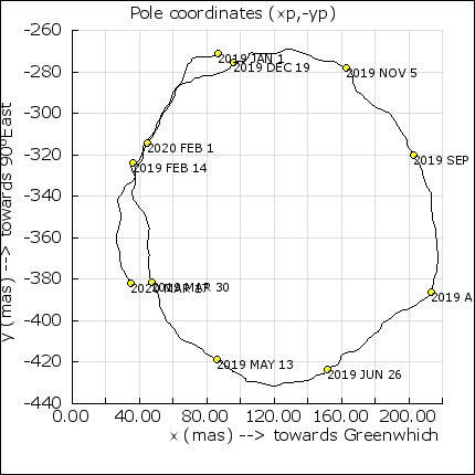
So with that spiral pattern of the pole shift, it would appear the shifting will now begin to accelerate, causing even more stress.  I have to wonder if the earth will relieve the stress points continually or if they will build up to massive tension and jump all at once.  If it turns out to be the later, we are in for one heck of a ride.

BTW, that mudslide video...  The storms we have been getting here have all been powerful storm cells.  No steady sprinkles of rain.  The sky goes dark, lightning, thunder, the pounding of hale stones and finally some heavy rain.  Within an hour or less, it's all gone.  My pine trees have already been stripped of over half their needles.  A few more rounds of this and they will all be bare--perfect for the expected fire season just around the corner.

Yes the clock is ticking and when the alarm goes off, there is no telling what sort of disaster lurks at the doorway.

freethisone

Re: Ice Age Model
« Reply #127, on May 28th, 2014, 04:29 AM »
i feel it is a continual force on earth, but during torque times delta T there will be abrupt shifting.  oceans re-equalize.

but this is what i had been thinking about the spirial in the picture..,, https://en.wikipedia.org/wiki/Vesica_piscis

freethisone

Re: Ice Age Model
« Reply #128, on May 28th, 2014, 06:08 PM »
Quote from freethisone on April 18th, 2014, 05:17 AM


so there it is right? M star plus planet. cheers.

"t Earth-size planet orbiting in the "habitable zone" of another star. The planet, named "Kepler-186f" orbits an M dwarf, or red dwarf, "

http://science.nasa.gov/science-news/science-at-nasa/2014/17apr_firstearth/ :dodgy:

who made the discovery? nasa? and Tony.. ppppp please.


Earth-Size Planet Found In The 'Habitable Zone' of Another Star

April 17, 2014: Using NASA's Kepler Space Telescope, astronomers have discovered the first Earth-size planet orbiting in the "habitable zone" of another star. The planet, named "Kepler-186f" orbits an M dwarf, or red dwarf, a class of stars that makes up 70 percent of the stars in the Milky Way galaxy. The discovery of Kepler-186f confirms that planets the size of Earth exist in the habitable zone of stars other than our sun.
The "habitable zone" is defined as the range of distances from a star where liquid water might pool on the surface of an orbiting planet. While planets have previously been found in the habitable zone, the previous finds are all at least 40 percent larger in size than Earth and understanding their makeup is challenging. Kepler-186f is more reminiscent of Earth.
splash
The artist's concept depicts Kepler-186f , the first validated Earth-size planet to orbit a distant star in the habitable zone.  More
Kepler-186f orbits its parent M dwarf star once every 130-days and receives one-third the energy that Earth gets from the sun, placing it nearer the outer edge of the habitable zone. On the surface of Kepler-186f, the brightness of its star at high noon is only as bright as our sun appears to us about an hour before sunset.
Auroras Underfoot (signup)
"M dwarfs are the most numerous stars," said Elisa Quintana, research scientist at the SETI Institute at NASA's Ames Research Center in Moffett Field, Calif., and lead author of the paper published today in the journal Science. "The first signs of other life in the galaxy may well come from planets orbiting an M dwarf."
However, "being in the habitable zone does not mean we know this planet is habitable," cautions Thomas Barclay, a research scientist at the Bay Area Environmental Research Institute at Ames, and co-author of the paper. "The temperature on the planet is strongly dependent on what kind of atmosphere the planet has. Kepler-186f can be thought of as an Earth-cousin rather than an Earth-twin. It has many properties that resemble Earth."
Kepler-186f resides in the Kepler-186 system, about 500 light-years from Earth in the constellation Cygnus. The system is also home to four companion planets: Kepler-186b, Kepler-186c, Kepler-186d, and Kepler-186e, whiz around their sun every four, seven, 13, and 22 days, respectively, making them too hot for life as we know it. These four inner planets all measure less than 1.5 times the size of Earth.
splash
The diagram compares the planets of our inner solar system to Kepler-186, a five-planet star system about 500 light-years from Earth in the constellation Cygnus.  More
Although the size of Kepler-186f is known, its mass and composition are not. Previous research, however, suggests that a planet the size of Kepler-186f is likely to be rocky.
"The discovery of Kepler-186f is a significant step toward finding worlds like our planet Earth," said Paul Hertz, NASA's Astrophysics Division director at the agency's headquarters in Washington.
The next steps in the search for distant life include looking for true Earth-twins -- Earth-size planets orbiting within the habitable zone of a sun-like star -- and measuring the their chemical compositions. The Kepler Space Telescope, which simultaneously and continuously measured the brightness of more than 150,000 stars, is NASA's first mission capable of detecting Earth-size planets around stars like our sun.
Looking ahead, Hertz said, "future NASA missions, like the Transiting Exoplanet Survey Satellite and the James Webb Space Telescope, will discover the nearest rocky exoplanets and determine their composition and atmospheric conditions, continuing humankind's quest to find truly Earth-like worlds."
Credits:
Production editor: Dr. Tony Phillips | Credit: Science@NASA

freethisone

Re: Ice Age Model
« Reply #129, on May 30th, 2014, 04:23 PM »Last edited on May 30th, 2014, 04:30 PM
Friday, May 30, 2014

Sangeang Api volcano (Sunda Islands, Indonesia): major explosive eruption with ash to 15-20 km altitude


erupts
Today's eruption column at Sangeang Api (photo: @Bambang_Bimawan / Twitter)
 A major explosive eruption occurred at the remote volcano this morning at around 08:30 UTC. A subplinian eruption column quickly rose to an estimated 50-65,000 ft (15-20 km) altitude and drifted several hundred km to the east and southeast.  ...more


 [read all]
Saturday, Jun 15, 2013

Sangeang Api volcano (Indonesia): alert level lowered

VSI decreased the alert level from 3 to 2 ("Waspada", on a scale of 4), as seismic activity has decreased recently.

Tuesday, May 21, 2013

Sangeang Api volcano (Indonesia): elevated seismic activity triggers alarm

An increase in seismicity since 26 April triggered VSI to rise the alert status from 2 to 3 on a scale of 1-4 (from "Waspada", "watch" to Siaga", alert). For the moment, only degassing has been observed as surface activity.  ...more

 
Thursday, Jan 03, 2013

Sangeang Api volcano (Indonesia): alert lowered on 21 Dec

CVGHM reported that during November through mid-December observers at the Sangeang, Bima observation post (50 km SW) noted occasional diffuse white plumes rising 5-15 m above Sangeang Api's crater.  ...more


to top


Friday, Oct 12, 2012

Sangeang Api volcano (Indonesia) activity update: increased seismicity, eruption warning

An eruption warning was issed for Sangeang Api volcano in the Banda Sea (aka "Etna of the Banda Sea"), based on increased seismic activity recorded by PVMBG. No surface activity has been detected so far, but a new eruption from the summit lava dome would not be a surprise.
Sangeang Api (Indonesia): A major explosive eruption occurred at the remote volcano this morning at around 08:30 UTC. A subplinian eruption column quickly rose to an estimated 50-65,000 ft (15-20 km) altitude and drifted several hundred km to the east and southeast.
Ash fall was reported in areas up to 30 km downwind from the volcano.
 ... [read more]


Ambrym (Vanuatu): (29 May)

Pagan (Mariana Islands): USGS reports that "low-level unrest continued at Pagan Volcano throughout the past week. Seismic activity remains above background. A vapor plume was visible in web camera and satellite images.
Volcanic gas from Pagan may be noticed downwind of the volcano as a distinctive sulfurous odor." The Aviation Color Code remains at YELLOW.

Santa María / Santiaguito (Guatemala): Ongoing rainfall has been causing a number of mud flows (lahars) in the rivers draining from Santiaguito, including Samala, San Isidro and Tambor.
A first large hot lahar descended the Nima I river bed yesterday. The sulfur-smelling mud flow was about 25 m wide and 3 m deep, carrying blocks of up to 50 cm in diameter and pieces of tree trunks and branches of up to 2 m. On its passage near the observatory, it made the ground vibrate. The lahar drained into the Samala river.

Fuego (Guatemala): Activity has decreased a bit. Strombolian explosions produced incandescent ejections to up to about 100 m and ash plumes rose to approx. 500 m.

San Miguel (El Salvador): The amplitude of internal vibration (tremor) at Chaparrastique volcano has suddenly dropped during the past 24 hours indicating that the volcanic system remains unstable, MARN informs in its latest special bulletin. Gas emissions remain elevated.
The possibility of an eruption from a summit or flank vent remains high and monitoring continues at highest level.

Turrialba (Costa Rica): The volcano could be becoming more active with increased degassing. An elevated SO2 concentration in the atmosphere above and near the volcano was visible on satellite data yesterday. Seismic activity appears to be elevated.

Galeras (Colombia): Activity at the volcano is currently low.
Seismic activity and gas emissions are at low to moderate levels. No recent ash emissions have occurred.

Cumbal (Colombia): Seismic unrest continues at the volcano, still on alert status Yellow, with little variation over the past months. The Pasto volcano observatory reported a 50% increase in earthquakes during the past week.
Most earthquakes were associated with internal fluid movements. The other quakes, all very small, were due to rock fracturing at shallow depths. No other signs of unrest were observed at the volcano recently.

Sotará (Colombia): Seismic activity associated with rock fracturing processes under the volcano showed a slight increase during the past week. The earthquakes occurred mainly under the Paletará valley, approximately 12 km northeast of the volcano at depths between 6 and 10 km, and had local magnitudes between 0.3 and 2.2 on the Richter scale.
Slight deformation has been detected at the volcano, but no changes or signs of activity are visible at the surface. The volcano remains at Yellow alert.

Cerro Negro de Mayasquer (Colombia): Unrest at the volcano continues in the form of earthquakes under the Chiles-Cerro Negro volcanic massif. During the past week, the monitoring network recorded around 6500 quakes, mostly located less than 4 km SW from the summit at depths ranging between 1 and 8 km and with magnitudes of up to 4.0 on the Richter scale.
Most of the earthquakes are volcanic-tectonic, i.e. associated with the fracturing of rock due to fluid pressure underground.
On May 21, 3 earthquakes at 02:53, 15:44 and 18:46 local time were felt felt by local inhabitants.

Reventador (Ecuador): A moderate explosion at the volcano produced an ash plume that rose to flight level 210 (21,000 ft / 6.5 km altitude), a pilot reported.

Volcano Activity Summary for 30 May 2014:

2014-05-30 08:29:49Kilauea Watch Orange
2014-05-30 13:34:37Shishaldin Watch Orange
2014-05-30 13:34:37Cleveland Advisory Yellow
2014-05-30 10:37:35Pagan Advisory Yellow
2014-05-30 13:34:37Veniaminof Advisory Yellow
2014-05-30 09:
Matt Watts

Re: Ice Age Model
« Reply #130, on May 30th, 2014, 06:01 PM »
Quote from freethisone on May 30th, 2014, 04:23 PM
Friday, May 30, 2014

Sangeang Api volcano (Sunda Islands, Indonesia): major explosive eruption with ash to 15-20 km altitude
I thought countries that signed-on to the Kyoto Treaty were required to limit emissions?   --   Man-made global warming my a$s.

So how many diesel particulate filters (DPFs) would be required to balance out the emissions from that single eruption?   Answer:  1000 times more than there are diesel engines on this planet.  Seriously I hope there is no one still alive that believes anything our illustrious politicians say.  It's time we take charge of our own future and tell our leaders to take a flying leap.

I don't know Free, I'm starting to feel like a kid again, "Are we there yet?"

Lynx

Re: Ice Age Model
« Reply #131, on May 31st, 2014, 12:01 AM »
I also don't believe in man-made global warming, but I do believe that all the politic scary tactics there are actually comes out as good and useful laws sometimes with regards to limiting emissions of sort, so even if what we put out into the atmosphere doesn't do jack poo to the climate change it's still processed to some degree, so we do get to breathe better air in our cities compared to what we had not only 10 years ago.

freethisone

Re: Ice Age Model
« Reply #132, on June 3rd, 2014, 02:07 PM »Last edited on June 3rd, 2014, 02:11 PM
let me show u again, how star trek  has information all along.

1701 is the space ship..   01-2017? any how i showed u pictures in the past, but are deleted after the forum change over to sanka..

now i have 3 stars, and a A far out u may say? but have you also seen my other discovery? a skull pyramid on mars. wow... mars needs moms freethisone.


i have named these objects the twins, temple one heartly 2. :dodgy:


Real data, and information, years worth..


Mars Baby..

freethisone

Re: Ice Age Model
« Reply #133, on June 12th, 2014, 06:48 PM »
Quote from freethisone on May 12th, 2014, 08:12 AM
5-12-14 this is what the spark gap trigger looks like. here we see the spectacular dance of the twins, but nasa refuses to let you see it this time around.
objects are seen at 11 and 4 oclock.


as you see volcanic eruption will now occure. these 2 to 3 weeks are criticle in establishing time variables.  this will lead to a second and third spark gap trigger causing the next few solar eruption. these eruption will be very high. m, and x class with a 7.0 or two that may follow. 2 to 6 weeks.

this will lead to external forces, and a great quake.


as for the magnetic poles of the sun claimed by leading that was to reverse in december, they had not released information as it doing so.
i say the reversal is confirmed, and doing so i in mid to late april this year.

july may have results for a great quake, but will soon be told once again this is possible. cause and effect chain that validates what we see.
http://www.swpc.noaa.gov/rt_plots/Xray.gif


Again this is a spark gap trigger, the sun suddenly goes into discharge. in this case the time frame was predictable. now we wait, :dodgy:

freethisone

Re: Ice Age Model
« Reply #134, on June 17th, 2014, 02:30 PM »
http://iswa.gsfc.nasa.gov/IswaSystemWebApp/iSWACygnetStreamer?timestamp=2038-01-23%2000:44:00&window=-1&cygnetId=40

magnetic field reversal data. very important. this earth magnetic field is mysteriously changing poles.
volcano eruption and data will follow.

proton will go negative , objects of high mass producing radial waves in space are converging.. this date on 6-17-14.
earthquake activity, and volcanic eruption. tornadoes could spawn within the next 2 to 4 weeks for the usa. and large storms in the sothern hem, is assumed.

i hope some have questions for me today.  everyday we have a gain more ,and more understanding...

Matt Watts

Re: Ice Age Model
« Reply #135, on June 17th, 2014, 04:40 PM »
Quote from freethisone on June 17th, 2014, 02:30 PM
i hope some have questions for me today.  everyday we have a gain more ,and more understanding...
So what can we predict as far as stabilization?  Will this pole shift diverge linearly or will it jump suddenly and reverberate for an extended period of time?  Is there any evidence around to predict what we might experience?

Seems to me I would expect the poles to essentially just disappear and then reappear reversed after some amount of time.  Much like demagnetizing a permanent magnet and then remagnetizing it.  I also heard at one time, while this process is taking place, the ozone layer would dissipate to nothing and have to rebuild itself once the pole reversal is complete.  This process could well be underway.  I'm hearing UV radiation is well above normal readings presently.

freethisone

Re: Ice Age Model
« Reply #136, on June 18th, 2014, 12:36 AM »
Good questions. as it may seem magnetic field changes would effect aircraft. keep a lookout for any new information.

what as far as stabilization? it may seem for the time being things will remain limbo. a full magnetic field reversal takes more time. perhaps as objects of high mass depart from our system of planets. the time frame i have is 2010 to 2021. this tells me more time is needed. as for poles i would expect it to be a physical change in axis. not a departure of magnetic field. a realignment. this tells us what we should expect. angular momentum changes, the re-equalization of the worlds oceans, and all the plates shifting to the east. 

CERN may assist in stabilization as a gyroscopic stabilizer only,. perhaps.....
Earth pole location on the data sheet tells us we are really closer to the equator. a 10 to 13 degree shift perhaps.

Uv radiation was assumed in this model, and you have verified this fact for me. this gives the model more predictable outcome in the future.
a great quake now will lead to a shift in pole position. it must be observed. the sun shifting far to the north. if not i could consider a temporary stabilization. until sept through dec 2014.

data for uv, xray, and gamma is skewed from the source. It should be assumed much higher .
predictable outcome is what this model is all about, and has been reporting. this is a model. not a article it takes cause and effect to a new level..
thanks Matt.


without all the data from all agency we are forced to make our  predictable outcome  based on well known principle, and what was learned from the last 4 years of data,


freethisone

Re: Ice Age Model
« Reply #137, on June 19th, 2014, 05:04 AM »Last edited on June 19th, 2014, 05:06 AM
magnetic anommoly


as you can see the curl is on the bottom of the graph, not at the top. left eye right eye... :@

freethisone

Re: Ice Age Model
« Reply #138, on June 19th, 2014, 05:10 AM »Last edited on June 19th, 2014, 09:42 AM
from space weather.. confirming for me magnetic annomoly..


MESOSPHERIC GRAVITY WAVES: Some thunderstorms are so powerful that they create ripples in the atmosphere 80 to 90 km high, at the edge of space itself. In satellite images such storms look like a giant atmospheric bulls-eye. It turns out these ripples are also visible from the ground. Amateur astronomer Thomas Ashcraft recently photographed them over New Mexico:


http://www.weather.com/video/tornadoes-cause-damages-in-us-49673?collid=/news/weather-tornadoes


freethisone

Re: Ice Age Model
« Reply #139, on June 23rd, 2014, 05:44 PM »Last edited on June 23rd, 2014, 05:48 PM
this may or may not be the only one of this size in a given 2 to 3 week period.. and a major spike or solar discharge to boot..

I give you a link for all the predicted volcanic eruption rather then adding it in text. there has been a time varable relation, and it has been put to the test  very well., producing a cause and effect chain that gives results time and time again.. O:-) O:-)

https://theextinctionprotocol.wordpress.com/category/volcanic-eruption/  a great source f geologic information. cheers..

Tsunami warning downgraded to advisory after 8.0 quake - USA TODAY


ABC News


Tsunami warning downgraded to advisory after 8.0 quake
USA TODAY
ANCHORAGE, Alaska (AP) — Authorities have downgraded the tsunami warning that was issued for parts of Alaska's Aleutian Islands after a magnitude-8.0 earthquake. Monday's quake generated small tsunamis, with waves of less than 7 inches, prompting ...
Alaska Earthquake: Tsunami Warning Prompts Evacuations As Magnitude 8.0 ...The Weather Channel
Tsunami advisory issued after 7.9 earthquake near AlaskaCNN
Large earthquake near Alaska triggers tsunami warningWashington Post
ABC News -KTUU.com
all 277 news articles »
Quote from freethisone on June 12th, 2014, 06:48 PM
http://www.swpc.noaa.gov/rt_plots/Xray.gif


Again this is a spark gap trigger, the sun suddenly goes into discharge. in this case the time frame was predictable. now we wait, :dodgy:

Nicadeamas

Re: Ice Age Model
« Reply #140, on June 23rd, 2014, 09:41 PM »
.
Well, this thread all on it's own is practically a book from my standard.
Freethisone... It is very clear you have an insane amount of interest in this. NICE!
I've skimmed through a bit of this and it's basically over my head, but a video has come to my mind.
I figure you'll go crazy over it, weather it's crazy in a good way or a bad way I don't know. Hope you enjoy it.

https://www.youtube.com/watch?v=44EKmYz6TMk#

freethisone

Re: Ice Age Model
« Reply #141, on June 24th, 2014, 04:42 PM »
6-24-2014

this may or may not be the only one of this size in a given 2 to 3 week period.. and a major spike or solar discharge to boot..

I give you a link for all the predicted volcanic eruption rather then adding it in text. there has been a time varable relation, and it has been put to the test  very well., producing a cause and effect chain that gives results time and time again.. O:-) O:-)

https://theextinctionprotocol.wordpress.com/category/volcanic-eruption/  a great source f geologic information. cheers..

Tsunami warning downgraded to advisory after 8.0 quake - USA TODAY


ABC News


Tsunami warning downgraded to advisory after 8.0 quake
USA TODAY
ANCHORAGE, Alaska (AP) — Authorities have downgraded the tsunami warning that was issued for parts of Alaska's Aleutian Islands after a magnitude-8.0 earthquake. Monday's quake generated small tsunami


i did not  like the movie thanks. try a search for h.a.b.b theory, it makes a couple of good points.


ice age model was not influenced by any other theory, i support expansion theory, by induction and external gravitational forces.
this is what i have proven.

thanks for the support.

were is the 7.0 pre-cursor? well perhaps dongraded, perhaps this was not the great quake expected? 2 to 3 weeks watch. volcanic eruption, and storms will spawn.

freethisone

Re: Ice Age Model
« Reply #142, on June 25th, 2014, 05:22 AM »
Quote from freethisone on June 19th, 2014, 05:10 AM
from space weather.. confirming for me magnetic annomoly..


MESOSPHERIC GRAVITY WAVES: Some thunderstorms are so powerful that they create ripples in the atmosphere 80 to 90 km high, at the edge of space itself. In satellite images such storms look like a giant atmospheric bulls-eye. It turns out these ripples are also visible from the ground. Amateur astronomer Thomas Ashcraft recently photographed them over New Mexico:


http://www.weather.com/video/tornadoes-cause-damages-in-us-49673?collid=/news/weather-tornadoes


June 12, 2014

A total of 13 aircraft suddenly vanished off radars for about 25 minutes on two occasions over Austria and neighboring countries, Austria's flight safety monitor said, calling for an EU probe into the “unprecedented” incidents. The flights vanished from air traffic controllers’ screens in  Austria on June 5 and June 10 for 25 minutes each time, Marcus  Pohanka of Austro Control – Austria’s flight safety organization  – said Thursday.  Air traffic control in neighboring regions of Germany and the  Czech Republic also reported similar problems.   Pohanka said the location, height, and identity of the 13  aircraft vanished over Austria both times, in what he called  “unprecedented” incidents, AP reported.   He added that some neighboring countries had experienced similar  problems. The daily Kurier, based in Vienna, elaborated that  similar problems were experienced by flight controllers in Munich  and Karlsruhe in Germany and in Prague, Czech Republic.  Poahanka declined to say which airlines and planes were involved,  but suggested that some may have been passenger jets, which fly  at high altitudes. The EU’s Eurocontrol and European Aviation  Safety Agency will investigate the incidents.   Poahanka stressed that at no time were any of the planes in  danger, as extra air traffic controllers were immediately called  to their posts and emergency measures were brought in, which  included immediately establishing voice contact with the pilots  and the widening of flight corridors.  The Kurier cited an unnamed expert as saying that the problem was  most likely to do with interference between the aircraft  transponders and the ground.

freethisone

Re: Ice Age Model
« Reply #143, on June 25th, 2014, 10:44 PM »Last edited on June 25th, 2014, 10:46 PM
Major eruptions are a leading roll in warming of planet. induction and eddy currents cause this effect.
the Mariana trench may Collapse, or they may nuke it..https://en.wikipedia.org/wiki/Mariana_Trench

this would be an act of war on america..https://www.youtube.com/watch?v=TK_UiLR3_rM#ws
Quote from freethisone on June 23rd, 2014, 05:44 PM
this may or may not be the only one of this size in a given 2 to 3 week period.. and a major spike or solar discharge to boot..

I give you a link for all the predicted volcanic eruption rather then adding it in text. there has been a time varable relation, and it has been put to the test  very well., producing a cause and effect chain that gives results time and time again.. O:-) O:-)

https://theextinctionprotocol.wordpress.com/category/volcanic-eruption/  a great source f geologic information. cheers..

Tsunami warning downgraded to advisory after 8.0 quake - USA TODAY


ABC News


Tsunami warning downgraded to advisory after 8.0 quake
USA TODAY
ANCHORAGE, Alaska (AP) — Authorities have downgraded the tsunami warning that was issued for parts of Alaska's Aleutian Islands after a magnitude-8.0 earthquake. Monday's quake generated small tsunamis, with waves of less than 7 inches, prompting ...
Alaska Earthquake: Tsunami Warning Prompts Evacuations As Magnitude 8.0 ...The Weather Channel
Tsunami advisory issued after 7.9 earthquake near AlaskaCNN
Large earthquake near Alaska triggers tsunami warningWashington Post
ABC News -KTUU.com
all 277 news articles »
Read or leave comments

Latest volcano webcam image
Latest volcano webcam image 


[enlarge map]
 
to top


Worldwide Volcano News and Updates:


latest (Jun 2014) | May 2014 | Apr 2014 | archive

Wednesday, Jun 25, 2014

Volcanic activity worldwide 25 Jun 2014: Stromboli


Strong eruption from Stromboli's NE vent and a weak lava overflow
Stromboli (Eolian Islands, Italy): A lava overflow erupted from the NW hornito on Sunday and traveled approx. 200 m down the Sciara del Fuoco. This followed a particularly intense phase of activity at this vent, marked by frequent and strong explosions and continuous spattering.  ...more


 [read all]
Volcanoes Today, 25 Jun 2014: Stromboli


Stromboli volcano (Eolian Islands, Italy): intense activity, short-lived lava flow on Sciara del Fuoco


Strong eruption from Stromboli's NE vent and a weak lava overflow

Lava overflow on Sunday (image annotated by Culture Volcan)
 A lava overflow erupted from the NW hornito on Sunday and traveled approx. 200 m down the Sciara del Fuoco. This followed a particularly intense phase of activity at this vent, marked by frequent and strong explosions and continuous spattering.  ...more


 [read all] More about Stromboli volcano

Monday, Jun 23, 2014

Volcanic activity worldwide 23 Jun 2014: Poas, Piton de la Fournaise, Sangeang Api, Ubinas


The new lava flow at Sangeang Api volcano (Photo: Aris Yanto)

Series of images from a phreatic eruption at Poás on 20 June (OVSICORI)
Sangeang Api (Indonesia): The volcano continues to extrude a lava flow and produces a steam-and-ash plume that rises several 100 m from the crater. Seismic activity remains high.  ...more


 [read all]

to top


Sangeangapi volcano (Indonesia): active lava flow and images from the devastation caused on 30 May


The new lava flow at Sangeang Api volcano (Photo: Aris Yanto)

Fresh pyroclastic flow deposits on the eastern shore (Photo: Aris Yanto)
 The volcano continues to extrude a lava flow and produces a steam-and-ash plume that rises several 100 m from the crater. Seismic activity remains high.  ...more

 [read all] More about Sangeang Api volcano

Ubinas volcano (Peru) activity update


Small ash emission from Ubinas volcano on Saturday
 Activity has been lower during the past days. Ash emissions have become less frequent and smaller. More about Ubinas volcano

Piton de la Fournaise volcano (La Réunion): eruption ends

The new eruption at the SE flank of the Dolomieu crater appears to have ended already during the night Saturday to Sunday 22 June. It had produced a series of small lava flows that traveled down to the base of the cone and remained well inside the Enclos.  ...more

 More about Piton de la Fournaise volcano

Poás volcano (Costa Rica): phreatic explosions from crater lake


Series of images from a phreatic eruption at Poás on 20 June (OVSICORI)
 Phreatic explosions from the acid crater lake continue to occur at the volcano. During a field campaign on 18 June, OVSICORI scientists observed 5 eruptions during 3 hours. Some of them damaged solar panels of measuring instruments.  ...more

 More about Poas volcano


to top


Saturday, Jun 21, 2014

Volcanic activity worldwide 21 Jun 2014: Piton de la Fournaise

Piton de la Fournaise (La Réunion): (21 Jun) A new eruption, the first after 3 1/2 years of repose, started at the volcano this morning at 01:35 local time, from a vent on the upper SE flank of the central crater (Dolomieu) cone.  ...more


 [read all]
Piton de la Fournaise volcano (La Réunion): new eruption

A new eruption, the first after 3 1/2 years of repose, started at the volcano this morning at 01:35 local time, from a vent on the upper SE flank of the central crater (Dolomieu) cone.  ...more


 [read all] More about Piton de la Fournaise volcano


Matt Watts

Re: Ice Age Model
« Reply #144, on June 26th, 2014, 01:10 PM »
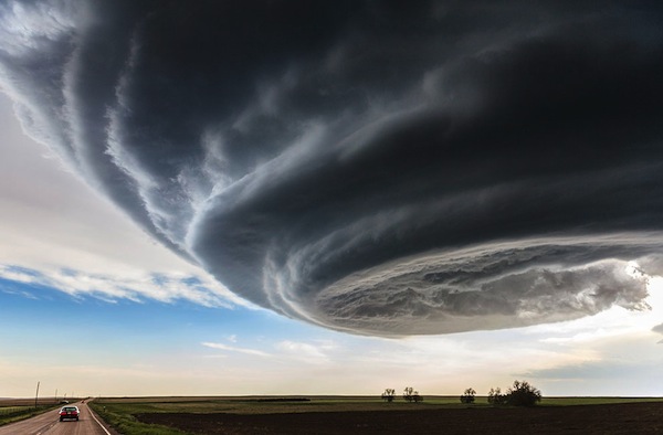
Is the earth trying to tell us something?


Photo taken in Julesburg, Colorado.

freethisone

Re: Ice Age Model
« Reply #145, on June 26th, 2014, 04:36 PM »Last edited on June 26th, 2014, 04:39 PM
Quote from freethisone on June 12th, 2014, 06:48 PM
http://www.swpc.noaa.gov/rt_plots/Xray.gif


Again this is a spark gap trigger, the sun suddenly goes into discharge. in this case the time frame was predictable. now we wait, :dodgy:
as we learn from real science cause and effect i verify atmospheric disturbances and discharge. the depleation of the earth oil will leave the transformer useless.. what follows below only renders proof to the pudding. so in 10 to 14 day we will have major x and m flair. cme. yes we will.


GIGANTIC SPRITES OVER THE USA: With the arrival of summer, thunderstorm activity is underway across the USA. We all know what comes out of the bottom of thunderstorms: lightning. Lesser known is what comes out of the top: sprites. "Lately there has been a bumper crop of sprites," reports Thomas Ashcraft, a longtime observer of the phenomenon. "Here is one of the largest' 'jellyfish' sprites I have captured in the last four years." The cluster shot up from western Oklahoma on June 23, so large that it was visible from Ashcraft's observatory in New Mexico 289 miles away:


"According to my measurements, it was 40 miles tall and 46 miles wide. This sprite would dwarf Mt. Everest!" he exclaims.

Also in New Mexico, Jan Curtis saw a cluster of red sprites just one night later, June 24. "I've always wanted to capture these elusive atmospheric phenomena and last night I was finally successful."

Although sprites have been seen for at least a century, most scientists did not believe they existed until after 1989 when sprites were photographed by cameras onboard the space shuttle. Now "sprite chasers" regularly photograph the upward bolts from their own homes.

Ashcraft explains how he does it: "My method for photographing sprites is fairly simple.  First I check for strong thunderstorms within 500 miles using regional radar maps accessible on the Internet. There must be a locally clear sky to image above the distant storm clouds. Then I aim my cameras out over the direction of the thunderstorms (which will be hot red or purple on the radar maps) and shoot continuous DSLR exposures. I usually shoot continuous 2 second exposures but if there is no moon then I will shoot up to 4 second exposures. Then I run through all the photographs and if I am lucky some sprites will be there. It might take hundreds to usually  thousands of exposures so be prepared for many shutter clicks. I use a modified near infrared DLSR but any DLSR will capture sprites. Note that it does require persistence and a little bit of luck."

Inhabiting the upper reaches of Earth's atmosphere alongside meteors, noctilucent clouds and some auroras, sprites are a true space weather phenomenon. Now is a good time to see them.

freethisone

Re: Ice Age Model
« Reply #146, on July 10th, 2014, 04:52 AM »
as a update to the predictions, they are very accurate. yes in 10 to 14 days we have major solar flairs and cme. i showed the magnetic anomoly.
i had stated storms and volcanic eruption would be significant.. we had super .typhoon,, tornadoes, snow, hail,, and even a hurricane. all in the time frame allowed. also we had our first 7..2 and 7..1 quake along with the great quake predicted.. if another major quake occures it will be within the next week to 10 days, by aug, and sept things will be well on there way for the worst to come.. 80 days to 120 day data log will follow..

very well ice age model predicted the cause and effect chain related to external net force precession. so yea its valid...

chime in if you agree??

Matt Watts

Re: Ice Age Model
« Reply #147, on July 10th, 2014, 07:17 AM »
Any idea where the seismic center of this great quake might be located?

If it happens anywhere around me, I probably should think about quitting my job as the facility I work in would likely be completely destroyed.  And I'd rather not be there when it happens.

freethisone

Re: Ice Age Model
« Reply #148, on July 10th, 2014, 08:20 AM »
Quote from freethisone on June 12th, 2014, 06:48 PM
http://www.swpc.noaa.gov/rt_plots/Xray.gif


Again this is a spark gap trigger, the sun suddenly goes into discharge. in this case the time frame was predictable. now we wait, :dodgy:
the predicted great quake had already happened.i posted the data. it happened shortly after this post.

another great quake you say.. it is a possibility, but ice age model predicted the last quake in a scintific manner. again this is 4 great quakes in a row i have made. yes as you see it must be caused by external forces..

read back a few posts. alaska baja mexico chili souther cali, japan. etc.  these are still the most likely to have a quake of this size.

freethisone

Re: Ice Age Model
« Reply #149, on July 10th, 2014, 08:21 AM »Last edited on July 10th, 2014, 08:23 AM
Quote from freethisone on July 10th, 2014, 08:20 AM
the predicted great quake had already happened.i posted the data. it happened shortly after this post.

another great quake you say.. it is a possibility, but ice age model predicted the last quake in a scintific manner. again this is 4 great quakes in a row i have made. yes as you see it must be caused by external forces..

read back a few posts. alaska baja mexico chili souther cali, japan. even russia, or indonisia. etc.  these are still the most likely to have a quake of this size. on june 23 2014 one moth after the last great quake may 23 quake of 2013.
ABC News


Tsunami warning downgraded to advisory after 8.0 quake
USA TODAY
ANCHORAGE, Alaska (AP) — Authorities have downgraded the tsunami warning that was issued for parts of Alaska's Aleutian Islands after a magnitude-8.0 earthquake. Monday's quake generated small tsunami