Ice Age Model

freethisone

RE: Ice Age Model
« Reply #50, on October 22nd, 2013, 05:57 PM »Last edited on October 22nd, 2013, 06:16 PM by freethisone
thinking about ice age model today. attributes an amazing flow of Antarctic tropical continental air flow.

historic, and verifying for ice age model. this is why hab failed...

see for yourself amazing air currents mixed with radiation ozone volcanic ash and dust methane. natural gas. sulfur dioxide, and co2 together with h20, h2o is the number one volcanic gas.

add images. update earthquake movie, show progression. show increased in magnitudes.

more. add new movie.

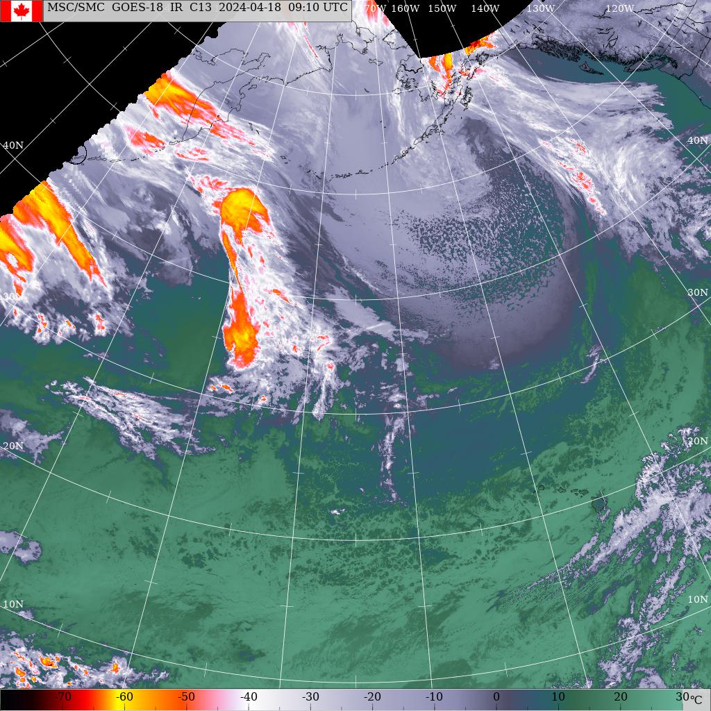
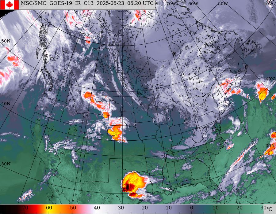
verify predicted proposals, fire ball we had. biggest storm in the southern hem ever recorded. this giant swirl above Canada crossing over to Europe and Siberia. this ice cap will form quickly or flooding will be a major concern in spring.

kelpers law, Regulus red October, Sonia..mirror.

temp 1 and h 2 comets what this means is 2016 is closer to a center point. the mass will progress because they will return. every 6 years 2010 being the last.
could ison be a smoke? or is ison mars because of it redness? or is it that red giants are running about in outer space? have u neutron star material as asterisks?
we a certainly not a single binary system of star. at least 3 or more influences sol, and is in its age..

these are the questions ice age model will overcome.  the progression to take place as a mounting of water vapor above the entire northern most hem. even down as far as? Utah..

predication helps explain what we are seeing.


If the bird that we see quacks like a duck and swims like a duck, and so on all the way down the line, then it‘s a duck.

If it crows like a rooster and can‘t swim, then it‘s not a duck. It
doesn‘t make any difference how many people insist on calling it a duck, —it still isn‘t a duck.

The physicists‘ atom is an imaginary atom constructed of
imaginary particles.

Irwin Schroedinger tells us, “If the question is asked, do the electrons actually exist on these orbits
within the atom, the answer has to be a decisive no. “The atom of modern physics can only be symbolized by
a partial differential equation in an abstract multi- dimensional space.”;)

:shy:
http://www.ssd.noaa.gov/goes/east/natl/flash-avn.html


freethisone

RE: Ice Age Model
« Reply #52, on October 23rd, 2013, 03:08 PM »Last edited on October 23rd, 2013, 05:16 PM by freethisone
all world news here.. click link   rare event page


Thursday 17th October 2013

http://www.travelandtourworld.com/news/article/eurasias-klyuchevskoy-volcano-erupts-spews-ash/


Klyuchevskoy Volcano, Kamchatka
Renewed eruptions began at Klyuchevskoy volcano, Kamchatka on 15th October 2013. The eruption was preceded by strong seismicity. Strombolian and Vulcanian eruptions occurred, and lava flows on the south-western, western and south-eastern volcanic flanks. Ash emissions reached 32,000 ft altitude and extended 480 km northwest, and 150 km southwest of the volcano. Klyuchevskoy is Kamchatka's highest and most active volcano. The volcano contains a 700 m wide summit crater. Between 500 m and 3600 m elevation there are about 80 lateral explosive vents and scoria cones.
More on Klyuchevskoy Volcano...
Volcanoes of Kamchatka...

Saturday 12th October 2013
White Island Volcano, New Zealand
A small eruption occurred at White Island volcano on 12th October 2013. The eruption lasted one minute and produced ash emissions which covered the crater floor. New Zealand Geonet said if the eruption occurred during the day it may have been life threatening to visitors.
More on White Island Volcano...
Volcanoes of New Zealand...

Thursday 3rd October 2013
Heard Island Volcano, Australian Territory
Pilot reports ash emissions at Heard Island volcano, southern Indian Ocean. Satellite image shows hotspot at summit on 1st October 2013.
More on Heard Island Volcano...
Volcanoes of Australia...

Thursday 19th September 2013
Sinabung Volcano, Indonesia
Eruption of Sinabung volcano in Sumatra occurred on 15th September. Ash emissions reached altitude of 20,000 ft. 15,000 people were evacuated from 11 villages, and a 3 km radius exclusion zone was places around the volcano. 250 people were treated for respiratory and eye problems.
More on Sinabung Volcano...
Volcanoes of Indonesia...

Tuesday 20th August 2013
Kilauea Volcano, Hawaii
Kilauea volcano remains active with lava flowing into the sea near Kupapa'u Point outside the national park boundary. At the summit a lava lake 220 m x 160 m is located in a pit 35 m below the floor of Halemaumau crater. The Kahauale'a 2 lava flow has been burning forest on the east rift zone.
More on Kilauea Volcano...
Volcanoes of Hawaii...

Tuesday 20th August 2013
Pacaya Volcano, Guatemala
Seismic activity increased at Pacaya volcano, Guatemala on 20th August 2013, indicating magma ascent. Pacaya is one of the world's most active volcanoes. It lies approximately 25 km south of Guatemala City. Activity at the volcano consists of strombolian eruptions, ash eruptions, and lava flows.
More on Pacaya Volcano...
Volcanoes of Guatemala...

Tuesday 20th August 2013
White Island Volcano, New Zealand
A small eruption occurred at White Island volcano on 20th August 2013. The eruption lasted 10 minutes and sent a plume to an altitude of 4000 m. The eruption occurred in a area of recent bubbling mud. The eruption was preceded by a short period of intense volcanic tremor the previous day. White Island is at level 2 alert (on scale of 0 to maximum 5).
More on White Island Volcano...
Volcanoes of New Zealand...

Monday 12th August 2013
Paluweh Volcano, Indonesia
An eruption occurred at Paluweh volcano, Indonesia on 11th August. Volcanic ash reached a height of 14,000 ft and extended 70 nautical miles west. The eruption resulted in 6 fatalities and 3000 people from Palue Island have been evacuated. The paroxysmal phase of the eruption lasted 7 minutes.
More on Paluweh Volcano...
Volcanoes of Indonesia...

Sunday 21st July 2013
Makura Volcano, Vanuatu
A magnitude 4.5 earthquake occurred under Makura volcano, Vanuatu on 20th July 2013. Makura is a little known volcano in central Vanuatu. It's summit lies on the island of Emae.
More on Makura Volcano...
Volcanoes of Vanuatu...:angel:

my data loghttps://www.youtube.com/watch?v=RSLFBAeoSms&feature=youtube_gdata:@

USGS

30 Days, Significant Worldwide
12 earthquakes - DownloadUpdated: 2013-10-23 17:03:42 UTC-05:00Showing event times using Local System Time (UTC-05:00)

    6.5 75km SW of Etchoropo, Mexico 2013-10-19 12:54:56 UTC-05:00 8.0 km
    6.8 64km WSW of Panguna, Papua New Guinea 2013-10-16 05:31:00 UTC-05:00 54.1 km
    7.1 2km NE of Catigbian, Philippines 2013-10-14 19:12:32 UTC-05:00 20.0 km
    6.4 30km W of Platanos, Greece 2013-10-12 08:11:52 UTC-05:00 36.2 km
    6.1 33km N of Gueiria, Venezuela 2013-10-11 21:10:29 UTC-05:00 79.4 km
    4.9 53km WNW of Eureka, California 2013-10-11 18:05:37 UTC-05:00 8.7 km
    6.4 113km SE of Amsterdam Island, 2013-10-04 12:26:13 UTC-05:00 12.9 km
    6.7 Sea of Okhotsk 2013-09-30 22:38:21 UTC-05:00 580.8 km
    6.5 78km NE of L'Esperance Rock, New Zealand 2013-09-30 00:55:55 UTC-05:00 42.1 km
    6.8 84km NNE of Awaran, Pakistan 2013-09-28 02:34:06 UTC-05:00 12.0 km
    7.1 46km SSE of Acari, Peru 2013-09-25 11:42:43 UTC-05:00 40.0 km
    7.7 63km NNE of Awaran, Pakistan::dodgy:


If the bird that we see quacks like a duck and swims like a duck, and so on all the way down the line, then it‘s a duck.

If it crows like a rooster and can‘t swim, then it‘s not a duck. It
doesn‘t make any difference how many people insist on calling it a duck, —it still isn‘t a duck.

The physicists‘ atom is an imaginary atom constructed of
imaginary particles.

Irwin Schroedinger tells us, “If the question is asked, do the electrons actually exist on these orbits
within the atom, the answer has to be a decisive no. “The atom of modern physics can only be symbolized by
a partial differential equation in an abstract multi- dimensional space.


therefore geologic, thermal, inductive forces or solar events have never been included in climate change theory, including Habs theory.

 in all reality this is as close as you get to cause, and effect. making prediction with verifiable results in a given frame.
ice age model with its antarctic, tropical, continental  air flow in the system is the number one cause to climate change and that cannot be  determined by co2 or man. lets see global warmers explain that with there models..

 in comparison with ice age model i have including external forces placed on the earths axis. induction, solar heating due to expansion, causing additional water vapor in the atmosphere.
the logical cause for the given effects we are observing.. external net force precession torque times delta T

freethisone

RE: Ice Age Model
« Reply #53, on October 24th, 2013, 02:51 PM »Last edited on October 24th, 2013, 06:37 PM by freethisone
"Mysterious hum in Hythe, Southampton (UK) blamed on mating fish
Posted on October 24, 2013   by The Extinction Protocol


https://www.youtube.com/watch?v=RSLFBAeoSms

odd that this radio sun was recorded, but it gives me the best explanation for the mystery sounds, and the Sweden spiral..


October 24, 2013 – UNITED KINGDOM – A mysterious hum has been keeping people in Hampshire awake all night, and scientists have said there could be something fishy about it. The noise “pulsates” through homes, forcing some residents of Hythe … Continue reading →
Posted in Earth Changes, Earth Watch, Hum noise, Pack Animal Aggression, Strange unexplained noises, Time - Event Acceleration, Unsolved Mystery   | Leave a comment


Wall of rock rises out of the ground in the Philippines:...........
       "new fault triggered large quake"<<<<<< i love how media or main stream report the reverse of the facts. A new fault line didn't trigger a large quake. A large quake trigger the fault to shift, and rise, not vise verse.

Posted on October 24, 2013   by The Extinction Protocol

  Residents stand next to a long earthen wall which formed following the Oct. 15 earthquake in Barangay Anonang in Inabanga, Bohol. Phivolcs scientists said the wall is the face of a previously unknown fault line which caused the magnitude "


so with that i bring your attention to what i presume caused the Swedish spiral to appear in the sky, also the reason for strange sounds heard in this particular town listed above.
if u want to hear the cause then watch this full movie, near the end you hear the sound of a radio sun, and a huge burst. one of witch has ever been recorded as far as i know..:(

Could Hab theory predict this? "A Wall of rock rises out of the ground in the Philippines: new fault triggered large quake"

Wall of rock rises out of the ground in the Philippines: new fault triggered large quake   all news link, its important..:heart:

"new fault triggered large quake"<<<<<< i love how media or main stream report the reverse of the facts. A new fault line didn't trigger a large quake. A large quake trigger the fault to shift, and rise, not vise verse.

they had said a great quake caused earth axis to shift, but now we know the facts as men. something, an external force had caused the axis to shift, and the great quake was a result.:blush:

freethisone

RE: Ice Age Model
« Reply #54, on October 30th, 2013, 06:48 AM »
Quote from freethisone on March 10th, 2013, 08:46 AM
At 5 min 12 sec, what do you see?:angel:

i see objects producing radial waves in the opposite direction of the sun.  i wanted you to visualize what i saw, considering this is before NASA added 10 more filter layers..

also you can now visualize the reason for polar cap melt. the sun shines on that section much longer then it should have. very few seen this footage. but i was vigilant.

notice darkness at the Florida tip, and sunshine extending to  the west coast. how is that for cause and effect?


 cheers. click link, perhaps its blocked.

https://www.youtube.com/watch?feature=player_embedded&v=-kYILVMBunc#!


this is also a good visualization aid dogone.
https://www.youtube.com/watch?feature=player_embedded&v=ohDPoIhA8nA#!
It is just strange to me how this movie will not load correctly, you must click the link inorder to see this movie.. if any problems with this movie please let me now..

Matt Watts

RE: Ice Age Model
« Reply #55, on October 30th, 2013, 08:04 AM »Last edited on October 30th, 2013, 08:24 AM by Matt Watts
I'd be curious as to all the image processing steps that are being done to this earth wobble video:

https://www.youtube.com/watch?v=ohDPoIhA8nA

https://www.youtube.com/watch?v=zq0jqhD46wE

It seems like someone hasn't properly set the camera registration points or the geostationary satellite is drifting.  Sure like to rule out all human, mechanical and optical artifacts before claiming the earth is wildly out of control.

Looking at just the latest animation, you can see something isn't right:
http://www.ssec.wisc.edu/data/geo/index.php?satellite=fy2d&channel=ir2&coverage=fd&file=jpg&imgoranim=8&anim_method=flash

Have to wonder if the satellite has been bumped by some space junk or something.

Don't see the same problem when viewing the COMS-1 satellite:
http://www.ssec.wisc.edu/data/geo/index.php?satellite=coms&channel=ir4&coverage=fd&file=jpg&imgoranim=8&anim_method=flash

Yeah, only seeing the problem on the FY2D and FY2E sats.  All the other ones look fine.  So if the earth was really wobbling, all those sats should show it.

freethisone

RE: Ice Age Model
« Reply #56, on October 30th, 2013, 08:35 AM »Last edited on October 30th, 2013, 09:48 AM by freethisone
Quote from Matt Watts on October 30th, 2013, 08:04 AM
I'd be curious as to all the image processing steps that are being done to this earth wobble video:

https://www.youtube.com/watch?v=ohDPoIhA8nA

https://www.youtube.com/watch?v=zq0jqhD46wE

It seems like someone hasn't properly set the camera registration points or the geostationary satellite is drifting.  Sure like to rule out all human, mechanical and optical artifacts before claiming the earth is wildly out of control.

Looking at just the latest animation, you can see something isn't right:
http://www.ssec.wisc.edu/data/geo/index.php?satellite=fy2d&channel=ir2&coverage=fd&file=jpg&imgoranim=8&anim_method=flash

Have to wonder if the satellite has been bumped by some space junk or something.

Don't see the same problem when viewing the COMS-1 satellite:
http://www.ssec.wisc.edu/data/geo/index.php?satellite=coms&channel=ir4&coverage=fd&file=jpg&imgoranim=8&anim_method=flash

Yeah, only seeing the problem on the FY2D and FY2E sats.  All the other ones look fine.  So if the earth was really wobbling, all those sats should show it.


thank you for this post, personally i have never monitored this system in the links you provided., the system i have captured in the movie i had monitored on a daily basis, until it had gone off line, although the images captured are true effects of earth shadow, and a shift in axial position.  an aviation control tower operator had confirmed he had also seen the effect of the shadow on earth shewn in the movie
link.

/watch?feature=player_embedded&v=-kYILVMBunc#!

 he only said it was very strange. again after that was mentioned the monitoring devise had been deleted, and is no longer operational for me. if you have a link to the shadow cast on earth like i had shewn in the movie please let me know.

the reason i believe the satellites are off is due to axial shift. you can also see that here  http://www.ssd.noaa.gov/goes/east/natl/flash-avn.html  note the black area on the right, this has progressively become more apparent over the last 2 to three years..

:exclamation:

i will find some older pictures of the image below and show you the progression of the dark area on the right, before axial shift ..:dodgy:

you also have the google  satellite doing strange things during axial shift, these x marks are odd.  so you can see it is not isolated to just one system of satellites.

freethisone

RE: Ice Age Model
« Reply #57, on November 17th, 2013, 05:38 AM »Last edited on November 17th, 2013, 06:36 AM by freethisone
Monthly Archives: November 2013

Powerful 7.8 magnitude earthquake strikes Scotia Sea
Posted on November 17, 2013 by The Extinction Protocol
November 17, 2013 – SOUTH AMERICA – A powerful 7.8 magnitude undersea earthquake struck in the Scotia Sea, a remote region in the far south Atlantic near Antarctica, US earthquake monitors reported Sunday. The quake struck at 0904 GMT in … Continue reading High-risk potential hazard zone, Lithosphere collapse & fisssure, Potential Earthchange hotspot, Seismic tremors, Signs of Magnetic Field weakening, Strange high tides & freak waves, Tectonic plate movement, Time - E

November 16, 2013 – SPACE – Sun is set to “flip upside down” within weeks as its magnetic field reverses polarity in an event that will send ripple effects throughout the solar system. Although it may sound like a catastrophic … Continue reading →

5.5 magnitude earthquake shakes Tokyo, halts trains: nerves frayed as Fukushima decomissioning reaches critical stage
Posted on November 16, 2013


How can the magnetic poles flip? with an actual rotation of the sun. why did they delete these images in 2010? start of solar cycle.

this must be up to Kepler law to deside.:dodgy:


the effects of negative gravity i describe. the earth is under pressure, and volcanoes are erupting, but under negative gravity the earth surface tention will relax, and the puss filled boil will oooz with ease. lava pools all over the world can be expected.  Siberia, Iceland, virgin islands, Mexico, alaska, Italy, Hawaii, California.  massive vapor releases will continue to enter our world. due to the elastic tension.  of a water balloon, caused by induction, equo-potentials in space. cause an emf. etnfp times d t. for verification of ice age model. ringing a bell of truth.

ocean floors will rise under these conditions, before we can assume core cooling, and relaxation..:@[/b]


https://www.youtube.com/watch?v=iE0tHDkscuE


https://www.youtube.com/watch?v=hObti5pLBL4:-/


https://www.youtube.com/watch?v=FNvecscoKJ0:s

← 5.5 magnitude earthquake shakes Tokyo, halts trains: nerves frayed as Fukushima decomissioning reaches critical stagePowerful 7.8 magnitude earthquake strikes Scotia Sea →


Sun magnetic field will ‘flip upside down’ within weeks, says NASA
Posted on November 16, 2013 by The Extinction Protocol


November 16, 2013 – SPACE – Sun is set to “flip upside down” within weeks as its magnetic field reverses polarity in an event that will send ripple effects throughout the solar system. Although it may sound like a catastrophic occurrence, there’s no need to run for cover. The sun switches its polarity, flipping its magnetic north and south, once every eleven years through an internal mechanism about which little is understood. The swap could however cause intergalactic weather fronts such as geomagnetic storms, which can interfere with satellites and cause radio blackouts. NASA said in August that the change would happen in three to four months time, but it is impossible to give a more specific date. Scientist won’t know for around another three weeks whether the flip is complete. The solar flip incidentally coincides with the near approach of Comet Ison. It’s unknown what effect, if any, solar behavior will have on the comet. The impact of the solar shake-up will be widespread, as the sun’s magnetic field exerts influence well beyond Pluto, and past NASA’s Voyager probes positioned near the edge of interstellar space.

The event will be watched closely by researchers at Stanford University’s Wilcox Solar Observatory, which monitors the sun’s magnetic field on a daily basis. Todd Hoeksema, director of the Wilcox Solar Observatory, said the polarity change is built up throughout the eleven year cycle through areas of intense magnetic activity known as sunspots which gradually move towards the poles, eroding the existing opposite polarity. Eventually, the magnetic field reduces to zero, before rebounding with the opposite polarity. “It’s kind of like a tide coming in or going out,” Hoeksema said. “Each little wave brings a little more water in, and eventually you get to the full reversal.” One of the most noticeable effect on Earth will be a boost in the occurrence, range and visibility of auroras – the Northern Lights. “It’s not a catastrophic event, it’s a large scale event that has some real implications, but it’s not something we need to worry about,” added Hoeksema. –Independent, TEP

About these ads
This entry was posted in Civilizations unraveling, Comets, Earth Changes, Earth Watch, Electric power disruption & grid failure, Geomagnetic Storm Alert, Prophecies referenced, Signs of Magnetic Field weakening, Solar Event, Space Watch, Time - Event Acceleration, Unusual solar behavior. Bookmark the permalink.
← 5.5 magnitude earthquake shakes Tokyo, halts trains: nerves frayed as Fukushima decomissioning reaches critical stagePowerful 7.8 magnitude earthquake strikes Scotia Sea →
3 Responses to Sun magnetic field will ‘flip upside down’ within weeks, says NASA
John says:
November 17, 2013 at 2:23 am
If the sun can reverse polarity quickly, perhaps the earth can do likewise. Do we know of any planets that reverse polarity on a short schedule like the sun?
Reply
The Extinction Protocol says:
November 17, 2013 at 11:46 am
E

Earth. Magnetic reversals can take days, as opposed to the thousands of year hypothesized by geologists.

“Since the field reversals are recorded in the fossil strata, the reversals must have happened when the strata were being laid down. Many creationists argue that Noah’s Flood produced most of the fossil layers in a single year. Thus, these reversals of the earth’s magnetic field have to be envisaged as occurring on average every week or two during the Flood year.

Such changes are obviously very rapid compared to the evolutionist’s multi-thousand-year or million-year-plus time-scales predicted by their dynamo hypothesis. However, creationists Dr. Thomas G. Barnes (Professor Emeritus of Physics, The University of Texas at El Paso) and Dr. D. Russell Humphreys (physicist at the Sandia National Laboratories, Albuquerque, and Adjunct Professor of Physics at the Institute for Creation Research, San Diego) have argued convincingly for a viable alternative hypothesis to the dynamo. They propose freely decaying electric currents in the earth’s core. This mechanism accounts for the real-time decay of the earth’s field over approximately the past 150 years, the current generated from such field decay correlating well with calculations of the amount of current actually present within the core. In addition, it can account for the magnetic reversals recorded in the rocks having taken place in a matter of only days to weeks!,”

Source: Fossil magnetism reveals rapid reversals of the earth’s magnetic field
http://creation.com/fossil-magnetism-reveals-rapid-reversals-of-the-earths-magnetic-field
Reply
teresa pedicone says:
November 17, 2013 at 4:43 am
Jeesh, what isn’t happening up in the sky this month??? I am ducking for cover everytime I hear a noise because of all I have heard! Praise God we have His Son in case I do get hit on the head by I son.!!! Keep looking up, Maranatha!!!
Reply


https://theextinctionprotocol.wordpress.com/2013/11/16/sun-magnetic-field-will-flip-upside-down-within-weeks-says-nasa/ link

Oh la la..

/watch?v=tkinObI6YZE

interesting .:angel:

/watch?v=RSLFBAeoSms

 high light of our age.

freethisone

RE: Ice Age Model
« Reply #58, on November 17th, 2013, 07:17 AM »Last edited on November 22nd, 2013, 09:11 PM by freethisone
the silence is Deafening on all aspects.

/watch?v=gB3hlTb794s

:angel:

/watch?v=xRhSWN7IgVA:blush:

/watch?v=vNfClJMnQxM

what did we do? closed the door on them, thats what we did..:P We have closed the Gap..

now pause at 4 min 2 sec.

these were  suspect objects in 2010 and is verifing. also you will finde the reflection in the glitter.

as predicted a periodic comet that can skim the sun.... 2010-2014 almost 4 full years of theory, and verifcation chain. cause and effect chain.. confirned..

theory was everything in this case. sorry to be the bringer of our reality.:s

"i poynting to many of these images in the past. in this case ice age model stands as support and light of truth.  Freethisone leading author on this study today. ..:D:angel:"


gravity.

freethisone

RE: Ice Age Model
« Reply #59, on November 18th, 2013, 11:17 AM »Last edited on November 22nd, 2013, 09:00 PM by freethisone
 Sinabung Volcano - John Seach
john

Sumatra, Indonesia

3.17 N, 98.392 E
summit elevation 2460 m
stratovolcano

Sinabung volcano is located in northern Sumatra adjacent to the town of Berastagi.

Sinabung volcano contains four overlapping summit craters, with solfatara activity present during the 20th century. The cone shows evidence of many lava flows.

Crater 1. Diameter 300 m.
Crater 2. Diameter 150 m. Contains crater lake.
Crater 3 (Batu Sigala). 160 m x 130 m. Contains crater lake.
Crater 4. Diameter 60 m.

Strong solfatara activity is found at crater 2 and 3.

2013 Eruption
Eruption of Sinabung volcano in September 2013 sent ash to altitude of 20,000 ft. 15,000 residents were evacuated.

2010 Eruption
Activity began at Sinabung volcano, on 27th August 2010 after 400 years of inactivity. Six large explosive eruptions have occurred at the volcano in the past month. These eruptions occurred on August 27 at 18:30 pm, August 29 at 0:10 pm, August 30 at 06: 23 pm, September 03 at 04:38 and 17:59 pm, and September 7, at 0:23:37 pm. The largest explosive eruption occurred on September 7. Eruption was accompanied by strong roar and rattled windows 8km from the volcano. An eruption column 5000 m high drifted southeast. As of September 22, 2010, activity was dominated by thick white gas emission, rising an average height of between 50-100 m above the crater.


Monday 18th November 2013
Merapi Volcano, Indonesia
An eruption occurred at Merapi volcano, Indonesia on 18th November 2013. Ash reached an altitude of 6500 ft and drifted 40 km east to the city of Solo.
More on Merapi Volcano...
Volcanoes of Indonesia...

Monday 18th November 2013
Sinabung Volcano, Indonesia
A large eruption of Sinabung volcano in Sumatra occurred on 18th November. Ash emissions reached 37,000 ft altitude and extended 35 nautical miles west.
More on Sinabung Volcano...
Volcanoes of Indonesia...

Thursday 14th November 2013
Yasur Volcano, Vanuatu
Over the past month increased activity has occurred at Yasur volcano, Vanuatu. A large amount of ash emissions have caused widespread damage to vegetation on Tanna Island. Ashfall was reported at Erromango Island 150 km north of Yasur volcano. On the evening of 3rd November 2013 John Seach witnessed large strombolian eruptions at Yasur. Explosions sent molten lava bombs up to 4 m diameter 250 m from the vent. Bombs were expelled onto the outside flanks of the cone, putting visitors at risk. The eruptions were some of the largest at the volcano since 1995.
More on Yasur Volcano...
Volcanoes of Vanuatu...

Saturday 26th October 2013
Zhupanovsky Volcano, Kamchatka
Explosive eruption began at Zhupanovsky volcano, Kamchatka on 23rd October 2013. Ash emissions reached 16,000 ft altitude and extended 75 km southeast of the volcano. Zhupanovsky volcano is located in eastern Kamchatka, 65 km north of Petropavlovsk-Kamchatsky. The last eruption of the volcano was in 1957.
More on Zhupanovsky Volcano...
Volcanoes of Kamchatka...

Thursday 17th October 2013
Klyuchevskoy Volcano, Kamchatka
Renewed eruptions began at Klyuchevskoy volcano, Kamchatka on 15th October 2013. The eruption was preceded by strong seismicity. Strombolian and Vulcanian eruptions occurred, and lava flows on the south-western, western and south-eastern volcanic flanks. Ash emissions reached 32,000 ft altitude and extended 480 km northwest, and 150 km southwest of the volcano. Klyuchevskoy is Kamchatka's highest and most active volcano. The volcano contains a 700 m wide summit crater. Between 500 m and 3600 m elevation there are about 80 lateral explosive vents and scoria cones.
More on Klyuchevskoy Volcano...

November 18, 2013 – ANTARCTICA – A volcano may be stirring more than a half-mile beneath a major ice sheet in Antarctica, raising the possibility of faster base melting that could ultimately affect climate. Seismologists working in a mountainous area of Marie Byrd Land in western Antarctica detected a swarm of low-magnitude earthquakes in 2010 and 2011 similar to those that can precede volcanic eruptions, according to a study published online Sunday in Nature Geoscience. The area of activity lies close to the youngest in a chain of volcanoes that formed over several million years, and the characteristics and depth of the seismic events are consistent with those found in volcanic areas of Alaska’s Aleutian Islands, the Pacific Northwest, Hawaii and Mt. Pinatubo in the Philippines, the study concludes. The tight focus of the 1,370 tremors and their deep, long-period waves helped researchers rule out ice quakes, glacial motion or tectonic activity as causes. So, too, did their apparent depth: At 15-25 miles beneath the sub-glacial surface, they are close to the local boundary between Earth’s crust and mantle. “At first I had no idea it was something volcanic, and then, as I started putting together all the pieces, it started looking more and more like I’d found a volcano,” said study co-author Amanda Lough, a seismology graduate student at Washington University in St. Louis.

Italy’s Mt. Etna spews fire in dramatic night time eruption
Posted on November 20, 2013 by The Extinction Protocol
November 20, 2013 – SICILY, ITALY – Mount Etna, the most active volcano in Europe, put on a spectacular show Saturday night and into Sunday. A massive eruption from Etna lit up the night sky over the island of Sicily. …

Posted on November 20, 2013 by The Extinction Protocol
November 20, 2013 – INDONESIA – The 8-kilometre-high ash cloud from Mount Sinabung dwarfs this villager in the north of the island of Sumatra, Indonesia, on Monday. The volcano rumbled back to life in 2010 after lying dormant for hundreds … C

Increased activity reported at volcanoes in Guatemala and Vanuatu
Posted on November 20, 2013 by The Extinction Protocol
November 20, 2013 – GUATEMALA – Two lava flows are active on the upper slopes of the volcano at the moment, to the Taniluya (south) and Ceniza canyon (SE). The effusive activity started on 11 Nov and increased on 18


all this at a time when it should have been expected. december will be eventful.

freethisone

RE: Ice Age Model
« Reply #60, on November 22nd, 2013, 09:52 PM »Last edited on November 28th, 2013, 08:30 AM by freethisone
Quote from freethisone on November 17th, 2013, 07:17 AM
what did we do? closed the door on them, that is what we did..:P We have closed the Gap..

now pause at 4 min 2 sec. at 1 min 1 second note the brightness from the upper left side within the crater.

these were  suspect objects in 2010 and is verifing. also you will finde the reflection in the glitter.

as predicted a periodic comet that can skim the sun.... 2010-2014 almost 4 full years of theory, and verifcation chain. cause and effect chain.. confirned..

theory was everything in this case. sorry to be the bringer of our reality.:s

"i poynting to many of these images in the past. in this case ice age model stands as support and light of truth.  Freethisone leading author on this study today. ..:D:angel:"

gravity.
/user/TheEnergyMotion/videos
the real work done, freethisone.:cool:
/watch?v=Tid8AfqO87c
/watch?v=eibDHnkKskI

the x marks the spot, these two comets are what we observe as partial cause, and effect. they reflect space electrical; net charge.

these 6 year periodic comets are called another.  here in 2007 we see two comets of the same. pause at 54 seconds to see an amazing object orbit another. link /watch?v=-zdB3A287Uc#t=45
 enjoy the cool sound. at 1min 4 seconds enters the twin from the right side of the frame. together in rotation.
 

Too be so blind, by its amazing light.

its a moving charge, there is a changing magnetic field. It reflect objects of large surface area of high potential. it is connected magnetic susspenstion.[/b][/size]

freethisone

RE: Ice Age Model
« Reply #61, on November 23rd, 2013, 12:45 PM »Last edited on November 23rd, 2013, 12:47 PM by freethisone
web link. no one is saying that they were to be expected. that they are one in the same in 2007 and 2011 and 2012 .:dodgy:

ice age model predicts gravity as inductive currents.

November 22, 2013 – CHILE – Increased seismic activity has been detected under the volcano, Chilean scientists reported. The devastating Plinian eruption of Chaitén in May 2008 forced the evacuation of the entire population of the small coastal town of Chaitén, located only a few kilometers south of the volcano. After the initial explosive phase, several lava domes have been growing slowly by extrusion of degassed, viscous magma. This phase ended in 2011 and since then, the volcano has only produced degassing. On 20 Nov at 08:07 (local time), a volcano-tectonic magnitude 2.4 earthquake occurred at 6 km depth north-east of the volcano. It was followed by a swarm of more than 80 quakes of mostly long-period type, characteristic for movements of fluids (gasses, water, and possibly magma) inside cracks inside the volcanic edifice. They are considered potential precursors to eruptive activity. In addition, pulses of volcanic tremor and a second volcanic-tectonic quakes of magnitude 2.7 at 11:39 local time, this time at shallow 4.4 km depth were recorded. –Volcano Discovery


freethisone

RE: Ice Age Model
« Reply #62, on November 28th, 2013, 07:26 AM »Last edited on November 28th, 2013, 09:47 AM by freethisone
antartic zonethe proof is in the pudding, a 20 degree latitude shift.

but note the white region, this will become the new antartic ice sheet colder over time, more water vapour.

:rolleyes:


http://science.nasa.gov/science-news/science-at-nasa/2013/10mar_greenhouseshift/


March 10, 2013: Vegetation growth at Earth's northern latitudes increasingly resembles lusher latitudes to the south, according to a NASA-funded study based on a 30-year record of ground-based and satellite data sets.

In a paper published Sunday, March 10, in the journal Nature Climate Change, an international team of university and NASA scientists examined the relationship between changes in surface temperature and vegetation growth from 45 degrees north latitude to the Arctic Ocean. Results show temperature and vegetation growth at northern latitudes now resemble those found 4 degrees to 6 degrees of latitude farther south as recently as 1982.

"Higher northern latitudes are getting warmer, Arctic sea ice and the duration of snow cover are diminishing, the growing season is getting longer and plants are growing more," said Ranga Myneni of Boston University's Department of Earth and Environment. "In the north's Arctic and boreal areas, the characteristics of the seasons are changing, leading to great disruptions for plants and related ecosystems."
Greenhouse Shift (splash)
Of the 10 million square miles (26 million square kilometers) of northern vegetated lands, 34 to 41 percent showed increases in plant growth (green and blue), 3 to 5 percent showed decreases in plant growth (orange and red), and 51 to 62 percent showed no changes (yellow) over the past 30 years. Satellite data in this visualization are from AVHRR and MODIS. Credit: NASA's Goddard Space Flight Center Scientific Visualization Studio
Myneni and colleagues used satellite data to quantify vegetation changes at different latitudes from 1982 to 2011. Data used in this study came from NOAA's Advanced Very High Resolution Radiometers (AVHRR) onboard a series of polar-orbiting satellites and NASA's Moderate Resolution Imaging Spectroradiometer (MODIS) instruments on the Terra and Aqua satellites.

As a result of enhanced warming and a longer growing season, large patches of vigorously productive vegetation now span a third of the northern landscape, or more than 3.5 million square miles (9 million square kilometers). That is an area about equal to the contiguous United States. This landscape resembles what was found 250 to 430 miles (400 to 700 kilometers) to the south in 1982.
Auroras Underfoot (signup)
"It's like Winnipeg, Manitoba, moving to Minneapolis-Saint Paul in only 30 years," said co-author Compton Tucker of NASA's Goddard Space Flight Center in Greenbelt, Md.
The Arctic's greenness is visible on the ground as an increasing abundance of tall shrubs and trees in locations all over the circumpolar Arctic. Greening in the adjacent boreal areas is more pronounced in Eurasia than in North America.

An amplified greenhouse effect is driving the changes, according to Myneni. Increased concentrations of heat-trapping gasses, such as water vapor, carbon dioxide and methane, cause Earth's surface, ocean and lower atmosphere to warm. Warming reduces the extent of polar sea ice and snow cover, and, in turn, the darker ocean and land surfaces absorb more solar energy, thus further heating the air above them.

"This sets in motion a cycle of positive reinforcement between warming and loss of sea ice and snow cover, which we call the amplified greenhouse effect," Myneni said. "The greenhouse effect could be further amplified in the future as soils in the north thaw, releasing potentially significant amounts of carbon dioxide and methane."
Greenhouse Shift (melt, 200px)
Trees take hold as permafrost thaws near the Altai Mountains in Russia. Credit: Terry Callaghan, EU-Interact/Sergey Kirpotin, Tomsk State University
To find out what is in store for future decades, the team analyzed 17 climate models. These models show that increased temperatures in Arctic and boreal regions would be the equivalent of a 20-degree latitude shift by the end of this century relative to a period of comparison from 1951-1980. However, researchers note that plant growth in the north may not continue on its current trajectory. The ramifications of an amplified greenhouse effect, such as frequent forest fires, outbreak of pest infestations and summertime droughts, may slow plant growth. Also, warmer temperatures alone in the boreal zone do not guarantee more plant growth, which also depends on the availability of water and sunlight.

"Satellite data identify areas in the boreal zone that are warmer and dryer and other areas that are warmer and wetter," said co-author Ramakrishna Nemani of NASA's Ames Research Center in Moffett Field, Calif. "Only the warmer and wetter areas support more growth."

"We found more plant growth in the boreal zone from 1982 to 1992 than from 1992 to 2011, because water limitations were encountered in the later two decades of our study," said co-author Sangram Ganguly of the Bay Area Environmental Research Institute and NASA Ames.

Data, results and computer codes from this study will be made available on NASA Earth Exchange (NEX), a collaborative supercomputing facility at Ames Research Center, Moffett Field, Calif. NEX is designed to bring scientists together with data, models and computing resources to accelerate research and innovation and provide transparency.

Author: Kathryn Hansen| Production editor: Dr. Tony Phillips | Credit: Science@NASA

:rolleyes:


add earth to 3rd picture. this is the curve our axis will follow.

freethisone

RE: Ice Age Model
« Reply #63, on November 28th, 2013, 08:36 AM »Last edited on November 28th, 2013, 09:26 AM by freethisone
update volcanic events November. earthquake data, magnetic anomolly. aurora respons, ionization. break down in core charge insulate. not enough oil in earth crust  to isolate  earth dynamic transformer.

flair, flux charts, images, and spark triggers. radius of gap, crossing  earth orbital plane, date. cause an emf, external force applied times delta T.

should cross this plane in either early december 2013 to mid to late january 2014.:s if i am to remember correctly, the former should hold true.

find chart link.
Monthly Archives: November 2013

Powerful 7.8 magnitude earthquake strikes Scotia Sea
Posted on November 17, 2013 by The Extinction Protocol
November 17, 2013 – SOUTH AMERICA – A powerful 7.8 magnitude undersea earthquake struck in the Scotia Sea, a remote region in the far south Atlantic near Antarctica, US earthquake monitors reported Sunday. The quake struck at 0904 GMT in … Continue reading High-risk potential hazard zone, Lithosphere collapse & fisssure, Potential Earthchange hotspot, Seismic tremors, Signs of Magnetic Field weakening, Strange high tides & freak waves, Tectonic plate movement, Time - E

November 16, 2013 – SPACE – Sun is set to “flip upside down” within weeks as its magnetic field reverses polarity in an event that will send ripple effects throughout the solar system. Although it may sound like a catastrophic … Continue reading →

5.5 magnitude earthquake shakes Tokyo, halts trains: nerves frayed as Fukushima decomissioning reaches critical stage
Posted on November 16, 2013


How can the magnetic poles flip? with an actual rotation of the sun. why did they delete these images in 2010? start of solar cycle.

this must be up to Kepler law to deside.Dodgy
the effects of negative gravity i describe. the earth is under pressure, and volcanoes are erupting, but under negative gravity the earth surface tention will relax, and the puss filled boil will oooz with ease. lava pools all over the world can be expected. Siberia, Iceland, virgin islands, Mexico, alaska, Italy, Hawaii, California. massive vapor releases will continue to enter our world. due to the elastic tension. of a water balloon, caused by induction, equo-potentials in space. cause an emf. etnfp times d t. for verification of ice age model. ringing a bell of truth.

ocean floors will rise under these conditions, before we can assume core cooling, and relaxation.


this is a specific time relation. i had said we would observe these effects, the shiffting of land mass to the east, red shift, eddy currents, and external forces. we should have a clear understanding now on ice age model. i continue to add support until the duck speaks. quack, Strange as it may be, i saw ducks flying north for the winter last night?
1 bumps

freethisone

RE: Ice Age Model
« Reply #64, on December 13th, 2013, 12:55 PM »Last edited on December 13th, 2013, 01:06 PM by freethisone
Tesla , Aeatheral Vortacle object! Aeatheral Vorticle object
Aeatheral Vorticle object  


The Interplanetary Magnetic Field It comes from the Sun!   The Sun is a big magnet.<<<<

During solar minimum the Sun's magnetic field, like Earth's, resembles that of an iron bar magnet, with great closed loops near the equator and open field lines near the poles. Scientists call such a field a "dipole." The Sun's dipolar field is about as strong as a refrigerator magnet, or 50 gauss. Earth's magnetic field is 100 times weaker.

During the years around solar maximum (2000 and 2001 are good examples) spots pepper the face of the Sun. Sunspots are places where intense magnetic loops -- hundreds of times stronger than the ambient dipole field -- poke through the photosphere. Sunspot magnetic fields overwhelm the underlying dipole; as a result, the Sun's magnetic field near the surface of the star becomes tangled and complicated.

The Sun's magnetic field isn't confined to the immediate vicinity of our star. The solar wind carries it throughout the solar system. Out among the planets we call the Sun's magnetic field the "Interplanetary Magnetic Field" or "IMF." Because the Sun rotates (once every 27 days) the IMF has a spiral shape -- named the "Parker spiral" after the scientist who first described it.

Above: Steve Suess (NASA/MSFC) prepared this figure, which shows the Sun's spiraling magnetic field from a vantage point ~100 AU from the Sun.

Earth has a magnetic field, too. It forms a bubble around our planet called the magnetosphere, which deflects solar wind gusts. (Mars, which does not have a protective magnetosphere, has lost much of its atmosphere as a result of solar wind erosion.) Earth's magnetic field and the IMF come into contact at the magnetopause: a place where the magnetosphere meets the solar wind. Earth's magnetic field points north at the magnetopause. If the IMF points south -- a condition scientists call "southward Bz" -- then the IMF can partially cancel Earth's magnetic field at the point of contact.


Above: Earth's magnetosphere. From the Oulu Space Physics Textbook.
"When Bz is south, that is, opposite Earth's magnetic field, the two fields link up," explains Christopher Russell, a Professor of Geophysics and Space Physics at UCLA. "You can then follow a field line from Earth directly into the solar wind" -- or from the solar wind to Earth. South-pointing Bz's open a door through which energy from the solar wind can reach Earth's atmosphere!

Southward Bz's often herald widespread auroras, triggered by solar wind gusts or coronal mass ejections that are able to inject energy into our planet's magnetosphere.
http://spaceweather.com/images2013/13dec13/cme_anim.gif?PHPSESSID=81uamtbu5sefbak46l7ot4g1c7

lanetary K-index
Now: Kp= 2 quiet
24-hr max: Kp= 2 quiet
explanation | more data
 
Interplanetary Mag. Field
Btotal: 7.5 nT
Bz: 1.1 nT south
explanation | more data
Updated: Today at 2056 U

freethisone

RE: Ice Age Model
« Reply #65, on December 30th, 2013, 02:17 AM »
The date i have this time is close to jan 5th 2014. 7.5 to great quake.  

am i as confident this time around? always i do my best to tell of these predictions.

also i have the sun poles in the process of change. add emerging rays. add charts. add volcanic eruption for dec.

note angular momentum changes, storms will  spawn, and are very powerful. the next 2 weeks will tell a story.

edit with real data. soon..

freethisone

Re: Ice Age Model
« Reply #66, on February 19th, 2014, 12:56 PM »Last edited on February 19th, 2014, 12:58 PM
Quote from freethisone on December 30th, 2013, 02:17 AM
The date i have this time is close to jan 5th 2014. 7.5 to great quake. 

am i as confident this time around? always i do my best to tell of these predictions.

also i have the sun poles in the process of change. add emerging rays. add charts. add volcanic eruption for dec.

note angular momentum changes, storms will  spawn, and are very powerful. the next 2 weeks will tell a story.

edit with real data. soon..
As a follow up, because this is my Model it has predicted for the months of dec jan feb 2013-2014 volcanic eruption due to induction.

the last 4 month of study reveal the story. today the activity is high on the sun, but in connection interacting with temple 1 heartley 2 comets, and its main body. MAGNETIC AND INDUCTIVE FORCES are AT its  HIGHEST POINT IN 4 YEARS..  rather i include one link so you may see it in real time unfold.

it is because we have a cyclical interaction as observed that allows the model to make accurate assumtions

odata reviewed for october through febuary.

earthquake activity is high as the earth axis is tourqued by external forces. PO PI Precession..


freethisone

Re: Ice Age Model
« Reply #68, on February 26th, 2014, 12:57 PM »
the shooting planet x-factor 7-day watch..update.. O:-)


freethisone

Re: Ice Age Model
« Reply #69, on February 26th, 2014, 04:51 PM »Last edited on February 26th, 2014, 04:54 PM


seated lady, seated bird men. this is indication of angular momentum change. increasing. that has strong storms related. air continues ANTARTIC TR CON flow.

PROTONS ARE GOING NEGATIVE.

THE LOAN x-5 ?? :huh:


freethisone

Re: Ice Age Model
« Reply #70, on March 1st, 2014, 03:17 AM »
How long before they realize objects have hit the sun, rather large in fact.

why cant i upload a picture Matt?

what hit the sun

freethisone

Re: Ice Age Model
« Reply #71, on March 5th, 2014, 05:27 PM »
Volcano News - John Seach
March 2014

Monitoring worldwide volcanic activity
26 years of volcano adventures
14 years on the internet - 2000-2014 . .
Reports are posted in Eastern Australian Time (UT +10 hr).
Archived Volcano News

See photos and video of John Seach flying Microlight aircraft
Volcano adventure flying coming soon!


Guatemala's Pacaya Volcano Spews Rock, Ash
GUATEMALA CITY March 2, 2014 (AP)
Associated Press
Guatemala authorities say the Pacaya volcano near Guatemala City has shot plumes of ash and vapor 2.3 miles (3.7 kilometers) high, while spewing glowing-hot rock.

The eruption early Sunday is the latest round of activity at the scenic volcano located just 30 miles (50 kms) south of Guatemala City.

The ash plume was moving southwest and west, away from the capital.

Pacaya is one of Guatemala's most active and picturesque volcanos. An eruption in January sent lava flowing down one side of the volcano, leading to evacuations.


Friday 14th February 20Kelut Volcano, Indonesia
A major eruption occurred at Kelut volcano (Kelud), Indonesia on 13th February 2014. The eruption was heard 200 km away in Yogyakarta. Ash reached an altitude of 55,000 ft and extended 500 nautical miles WSW. A 10 km exclusion zone was placed around the volcano, and 200,000 people ordered to evacuate. Kelut volcano has a history of dangerous eruptions.
More on Kelut Volcano...
Volcanoes of Indonesia...

Monday 3rd February 2014
Kelut Volcano, Indonesia
Kelut volcano, Indonesia was raised to level 2 alert (Waspada) on 2nd February 2014. Between 22-31 January 2014 there were 234 shallow volcanic earthquakes recorded at the volcano. Earthquakes had a focus of 2-8 km depth. Water in the crater increased by 5.5 degrees Celsius. A 2 km radius exclusion zone was placed around the crater.
More on Kelut Volcano...
Volcanoes of Indonesia...

Saturday 1st February 2014
Sinabung Volcano, Indonesia
On 1st February 2014, at least 14 people were killed by a pyroclastic flow inside the restricted zone at Sinabung volcano, Indonesia. A large eruption sent the burning cloud into Sukameriah village 2.7 kilometres from the volcano's crater. More victims are suspected but rescue teams were prevented from entering the area due to the risk of more pyroclastic flows. The restricted zone is between 5-7 km radius from the crater. Sinabung volcano began erupting in 2010 after being dormant for centuries.
More on Sinabung Volcano...
Volcanoes of Indonesia...

Wednesday 22nd January 2014
Sinabung Volcano, Indonesia
During an expedition to Sinabung volcano, Sumatra in January 2014 John Seach observed eruptions. Pyroclastic flows were descending the southeast flank of the volcano with a runout distance of 5 km. On 14th January there were almost continuous pyroclastic flows. The eruption was accompanied by ash emission from two locations on the summit of the volcano. Pyroclastic flows were approaching close the the edge of the exclusion zone. Heavy ashfall occurred on the south and southwest of the volcano causing damage to crops.
More on Sinabung Volcano...
Volcanoes of Indonesia...

Tuesday 2nd January 2014
Vanua Lava Volcano, Indonesia
A magnitude 6.6 earthquake hit 20 km west of Vanuatu Lava volcano, Vanuatu on 2nd January 2014. The earthquake focus was at depth of 200 km. The volcano is also known as Mt Suretamatai. It last erupted 1965 simultaneously with nearby Gaua volcano.
More on Vanua Lava Volcano...
Volcanoes of Vanuatu...

Tuesday 2nd January 2014
Sinabung Volcano, Indonesia
Ash emissions at Sinabung volcano, Sumatra reached 20,000 ft altitude on 2nd January 2014. In the past 24 hours there have been continuous eruptions and pyroclastic flows. Almost 20,000 people have been evacuated. The volcano has remained on RED alert for the past 39 days.
More on Sinabung Volcano...
Volcanoes of Indonesia...

Tuesday 17th December 2013
Sinabung Volcano, Indonesia
Seismic activity has increased at Sinabung volcano in Sumatra. On 14th December 1000 earthquakes were recorded at the volcano. Magma has been detected at a depth of 2 km. A 5 km radius exclusion zone has been placed around the volcano. Sinabung volcano remains on RED alert.
More on Sinabung Volcano...
Volcanoes of Indonesia...

Tuesday 10th December 2013
Sinabung Volcano, Indonesia
Large eruption occurred at Sinabung volcano, Sumatra on 10th December 2013. Ash reached altitude 38,000 ft and extended 50 nautical miles northwest. Sinabung volcano is located in northern Sumatra adjacent to the town of Berastagi. Eruptions began in 2010 after being dormant for 1200 years.
More on Sinabung Volcano...
Volcanoes of Indonesia...

Sunday 1st December 2013
Sinabung Volcano, Indonesia
Eruptions continue at Sinabung volcano, Sumatra. Almost 18,000 people have been evacuated. The volcano remains at the highest level of alert (AWAS).
More on Sinabung Volcano...
Volcanoes of Indonesia...

Monday 25th November 2013
Sinabung Volcano, Indonesia
An increase in activity has occurred at Sinabung volcano, Sumatra over the past week. On 18th November 2013 ash emissions reached altitude of 37,000 ft. On 24th November Sinabung was raised to the maximum level 4 alert (awas). Four centimetre diameter projectiles were ejected 4 kilometres from volcano. A 5 km radius exclusion zone has been placed around the volcano, and 15,000 people evacuated. Relief supplies needed include masks, clothing, blankets, mats, baby food, sanitation, psychosocial, and health services.
More on Sinabung Volcano...
Volcanoes of Indonesia...

Thursday 21st November 2013
Nishino-shima Volcano, Indonesia
An eruption of Nishino-shima Volcano, Japan occurred on 20th November 2013. The eruption created a small island. Nishino-shima Volcano is located 950 km south of Tokyo, in the volcano islands. It has a volume of 534 cubic km. Between 1974 and 2013 there were several unconfirmed underwater eruptions at the volcano.
More on Nishino-shima Volcano...
Volcanoes of Indonesia...

Monday 18th November 2013
Merapi Volcano, Indonesia
An eruption occurred at Merapi volcano, Indonesia on 18th November 2013. Ash reached an altitude of 6500 ft and drifted 40 km east to the city of Solo.
More on Merapi Volcano...
Volcanoes of Indonesia...

Monday 18th November 2013
Sinabung Volcano, Indonesia
A large eruption of Sinabung volcano in Sumatra occurred on 18th November. Ash emissions reached 37,000 ft altitude and extended 35 nautical miles west.
More on Sinabung Volcano...
Volcanoes of Indonesia...

Thursday 14th November 2013
Yasur Volcano, Vanuatu
Over the past month increased activity has occurred at Yasur volcano, Vanuatu. A large amount of ash emissions have caused widespread damage to vegetation on Tanna Island. Ashfall was reported at Erromango Island 150 km north of Yasur volcano. On the evening of 3rd November 2013 John Seach witnessed large strombolian eruptions at Yasur. Explosions sent molten lava bombs up to 4 m diameter 250 m from the vent. Bombs were expelled onto the outside flanks of the cone, putting visitors at risk. The eruptions were some of the largest at the volcano since 1995.
More on Yasur Volcano...
Volcanoes of Vanuatu...

Saturday 26th October 2013
Zhupanovsky Volcano, Kamchatka
Explosive eruption began at Zhupanovsky volcano, Kamchatka on 23rd October 2013. Ash emissions reached 16,000 ft altitude and extended 75 km southeast of the volcano. Zhupanovsky volcano is located in eastern Kamchatka, 65 km north of Petropavlovsk-Kamchatsky. The last eruption of the volcano was in 1957.
More on Zhupanovsky Volcano...
Volcanoes of Kamchatka...

Thursday 17th October 2013
Klyuchevskoy Volcano, Kamchatka
Renewed eruptions began at Klyuchevskoy volcano, Kamchatka on 15th October 2013. The eruption was preceded by strong seismicity. Strombolian and Vulcanian eruptions occurred, and lava flows on the south-western, western and south-eastern volcanic flanks. Ash emissions reached 32,000 ft altitude and extended 480 km northwest, and 150 km southwest of the volcano. Klyuchevskoy is Kamchatka's highest and most active volcano. The volcano contains a 700 m wide summit crater. Between 500 m and 3600 m elevation there are about 80 lateral explosive vents and scoria cones.
More on Klyuchevskoy Volcano...
Volcanoes of Kamchatka...

Saturday 12th October 2013
White Island Volcano, New Zealand
A small eruption occurred at White Island volcano on 12th October 2013. The eruption lasted one minute and produced ash emissions which covered the crater floor. New Zealand Geonet said if the eruption occurred during the day it may have been life threatening to visitors.
More on White Island Volcano...
Volcanoes of New Zealand...

Thursday 3rd October 2013
Heard Island Volcano, Australian Territory
Pilot reports ash emissions at Heard Island volcano, southern Indian Ocean. Satellite image shows hotspot at summit on 1st October 2013.
More on Heard Island Volcano...
Volcanoes of Australia...

Thursday 19th September 2013
Sinabung Volcano, Indonesia
Eruption of Sinabung volcano in Sumatra occurred on 15th September. Ash emissions reached altitude of 20,000 ft. 15,000 people were evacuated from 11 villages, and a 3 km radius exclusion zone was places around the volcano. 250 people were treated for respiratory and eye problems.
More on Sinabung Volcano...
Volcanoes of Indonesia...

Tuesday 20th August 2013
Kilauea Volcano, Hawaii
Kilauea volcano remains active with lava flowing into the sea near Kupapa'u Point outside the national park boundary. At the summit a lava lake 220 m x 160 m is located in a pit 35 m below the floor of Halemaumau crater. The Kahauale'a 2 lava flow has been burning forest on the east rift zone.
More on Kilauea Volcano...
Volcanoes of Hawaii...

Tuesday 20th August 2013
Pacaya Volcano, Guatemala
Seismic activity increased at Pacaya volcano, Guatemala on 20th August 2013, indicating magma ascent. Pacaya is one of the world's most active volcanoes. It lies approximately 25 km south of Guatemala City. Activity at the volcano consists of strombolian eruptions, ash eruptions, and lava flows.
More on Pacaya Volcano...
Volcanoes of Guatemala...

Tuesday 20th August 2013
White Island Volcano, New Zealand
A small eruption occurred at White Island volcano on 20th August 2013. The eruption lasted 10 minutes and sent a plume to an altitude of 4000 m. The eruption occurred in a area of recent bubbling mud. The eruption was preceded by a short period of intense volcanic tremor the previous day. White Island is at level 2 alert (on scale of 0 to maximum 5).
More on White Island Volcano...
Volcanoes of New Zealand...

Monday 12th August 2013
Paluweh Volcano, Indonesia
An eruption occurred at Paluweh volcano, Indonesia on 11th August. Volcanic ash reached a height of 14,000 ft and extended 70 nautical miles west. The eruption resulted in 6 fatalities and 3000 people from Palue Island have been evacuated. The paroxysmal phase of the eruption lasted 7 minutes.
More on Paluweh Volcano...
Volcanoes of Indonesia...

Sunday 21st July 2013
Makura Volcano, Vanuatu
A magnitude 4.5 earthquake occurred under Makura volcano, Vanuatu on 20th July 2013. Makura is a little known volcano in central Vanuatu. It's summit lies on the island of Emae.
More on Makura Volcano...
Volcanoes of Vanuatu...

freethisone

Re: Ice Age Model
« Reply #72, on March 5th, 2014, 10:56 PM »
results.


5.3
31km S of Villa Alemana, Chile
2014-03-05 23:37:06 UTC-05:0058.9 km
6.3
262km ESE of Sola, Vanuatu
2014-03-05 04:56:58 UTC-05:00636.8 km
6.5
110km NW of Nago, Japan
2014-03-02 15:11:22 UTC-05:00111.2 km
6.2
23km WSW of Jiquilillo, Nicaragua
2014-03-02 04:37:56 UTC-05:0072.6 km
6.5
170km NNE of Bathsheba, Barbados
2014-02-18 04:27:13 UTC-05:0016.9 km
4.1
12km WNW of Edgefield, South Carolina
2014-02-14 22:23:38 UTC-05:005.2 km
6.9
268km ESE of Hotan, China
2014-02-12 04:19:48 UTC-05:0010.0 km
6.5
34km E of Port-Olry, Vanuatu

freethisone

Re: Ice Age Model
« Reply #73, on March 5th, 2014, 10:58 PM »
results
Name   Location   Activity
Kelut   Eastern Java (Indonesia)   New
Marapi   Indonesia   New
Pacaya   Guatemala   New
Poás   Costa Rica   New
Popocatépetl   Mexico   New
Tungurahua   Ecuador   New
Aira   Kyushu (Japan)   Ongoing
Chirinkotan   Kuril Islands (Russia)   Ongoing
Chirpoi   Kuril Islands (Russia)   Ongoing
Colima   Mexico   Ongoing
Dukono   Halmahera (Indonesia)   Ongoing
Etna   Sicily (Italy)   Ongoing
Karymsky   Eastern Kamchatka (Russia)   Ongoing
Kilauea   Hawaiian Islands (USA)   Ongoing
Shiveluch   Central Kamchatka (Russia)   Ongoing
Sinabung   Indonesia   Ongoing